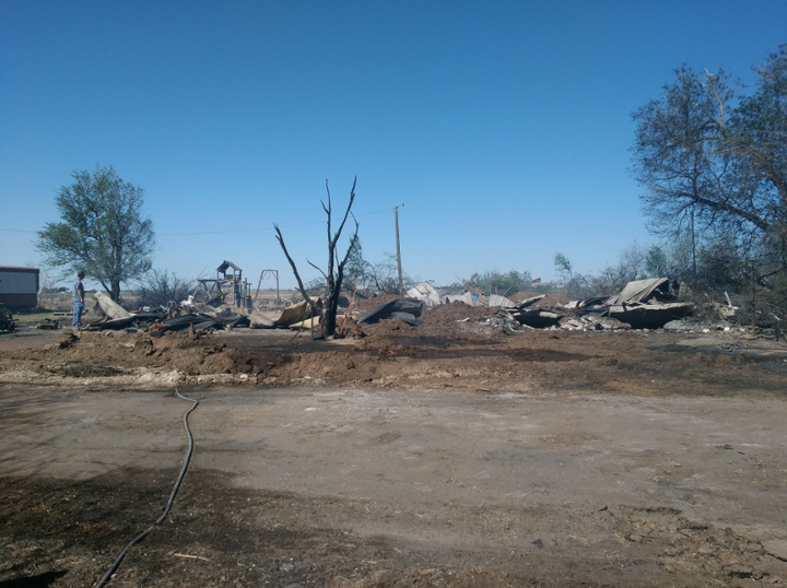
Wildfires continued to rip through western Oklahoma on Thursday, burning over 300,000 acres of land and leaving behind dozens of destroyed homes.
Flames broke out last week amid historic fire conditions, including dry weather and high winds. At least two people have been killed as a result of the fires, including a 61-year-old man who had been out hunting and a woman, who was found dead in her vehicle.
Exceptional droughts have plagued large parts of the southern plains, Todd Lindley, a meteorologist for the National Weather Service in Norman, Oklahoma, told HuffPost. Some areas of the state have gone roughly 185 days without a quarter inch of rainfall, he said.
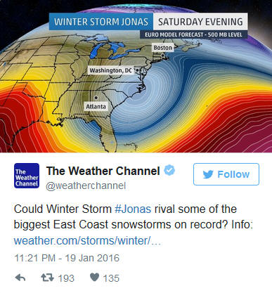
Washington, D.C., is bracing to be in the crosshairs of a monster storm that could clobber the East Coast with snow and ice this weekend, forecasters warned.
“Confidence is high in this being a historic snowstorm for the Mid-Atlantic region,” NBC meteorologist Bill Karins said Wednesday.
The nation’s capital could get 18 to 24 inches of snow, according to the Weather Channel. The National Weather service issued a blizzard watch for the city on Wednesday, and will be in effect Friday afternoon through late Saturday night. Baltimore, Maryland, was also included in the blizzard watch.
Tens of millions of people in the middle of the country are facing a three-day tornado threat — including places that were ravaged earlier this week by an outbreak of twisters.
A tornado touched down near Throckmorton, Texas, the National Weather Service said, but there were no reports of serious damage. Tornadoes were also seen touching down in Haskell and Wilbarger counties, also in Texas, on Friday, the NWS said.
Thunderstorms, carrying large hail, broke out across the Southern Plains Friday, and a tornado watch was posted for parts of Texas, Oklahoma, Colorado and New Mexico Friday night.
The threat extends through Sunday — Mother’s Day — and includes a busy weekend of commencement ceremonies. The University of Oklahoma already canceled graduation activities scheduled for Friday night due to “dangerous weather conditions.”
UPDATED 4 p.m. ET:The National Weather Service upgraded the blizzard watch to a blizzard warning for Boston, which is in effect from Saturday at 7 p.m. ET to Sunday at 11 a.m. ET. The blizzard warnings and watches stretch from Cape Cod all the way to the border between Maine and Canada. The NWS is forecasting between 10 to 14 inches of snow in Boston on top of the three to four feet already on the ground, and is also warning of a life-threatening combination of powerful winds and cold temperatures during and in the wake of the storm through Sunday.
The powerful Valentine’s Day storm set to blast eastern New England this weekend with roaring, frigid winds, heavy snow and pounding surf will be so strong that it can be compared in some ways to a Category 2 hurricane.
Fortunately, though, it will not bring the same impacts as a hurricane of that intensity, but its effects on multiple locations — from Providence and Boston to Portland and Bangor, Maine — will be similar to a winter hurricane, with power outages, tree and structural damage, and coastal flooding. Depending on the storm’s exact track, it could dump a foot or more of additional snow in the Boston area, with even more snow in coastal New Hampshire and Maine.
Cities across the Northeast mobilized snowplows and airlines canceled thousands of flights Monday as a potentially historic storm pushed its way up the Philadelphia-to-Boston corridor with what forecasters said could be up to 2 feet of snow.
More than 4,000 flights were canceled or delayed, schools planned to close early and a hospital in New York increased staff and outfitted its vehicles with snow traveling gear.
The National Weather Service said the nor’easter would bring heavy snow, powerful winds and widespread coastal flooding starting Monday and through Tuesday. A blizzard warning was issued for a 250-mile stretch of the Northeast, including New York and Boston.
.
A snowplow follows a pedestrian on a path in New York City’s Central Park. (FILE)
.
.
Click link below for story, video, photos and slideshow:
Blistering cold air blasted across most of the country Tuesday, and a lake-effect snowstorm hammered the Great Lakes and parts of New York, hitting some places with more than 6 feet of snow — so much that the National Guard was activated around Buffalo. More than 100 miles of the New York State Thruway were closed, trapping a college basketball team on its bus more than 24 hours and counting.
The National Weather Service said Tuesday night that some areas of the Buffalo suburbs were approaching 76 inches of snow since Monday — that’s the record for snowfall over a 24-hour period anywhere in the U.S. ever.
“This is a very intense storm, one of those record storms that we are going to remember for a few years beyond this date,” Buffalo Public Works Commissioner Steven Stepniak said.
Severe weather, including a possible derecho, could affect 64 million people in 10 states
A gigantic line of powerful thunderstorms could affect one in five Americans on Wednesday as it rumbles from Iowa to Maryland packing hail, lightning and tree-toppling winds.
Meteorologist are warning that the continuous line of storms may even spawn an unusual weather event called a derecho (duh-RAY’-choh), which is a massive storm of strong straight-line winds spanning at least 240 miles. Wednesday’s storms are also likely to generate tornadoes and cause power outages that will be followed by oppressive heat, said Bill Bunting, operations chief at the National Weather Service’s Storm Prediction Center in Norman, Okla.
The risk of severe weather in Chicago, Indianapolis, Cincinnati and Columbus, Ohio, is roughly 45 times higher than on a normal June day, Bunting said. Detroit, Baltimore, Washington, Milwaukee, Pittsburgh and Louisville, Ky., have a risk level 15 times more than normal. All told, the area the weather service considers to be under heightened risk of dangerous weather includes 64 million people in 10 states.
.
.
.Click link below for article and slideshow of storm photos:
ST. PAUL, Minn. (AP) – As heat across a big chunk of the U.S. drives people into pools and lakes to cool off, public health officials are worried about a heightened risk of drowning.
.
As the heat wave continues, public health officials fear more fatalities
Film and Writing Festival for Comedy. Showcasing best of comedy short films at the FEEDBACK Film Festival. Plus, showcasing best of comedy novels, short stories, poems, screenplays (TV, short, feature) at the festival performed by professional actors.


 .
.


 Image: Bob Al-Greene/Mashable
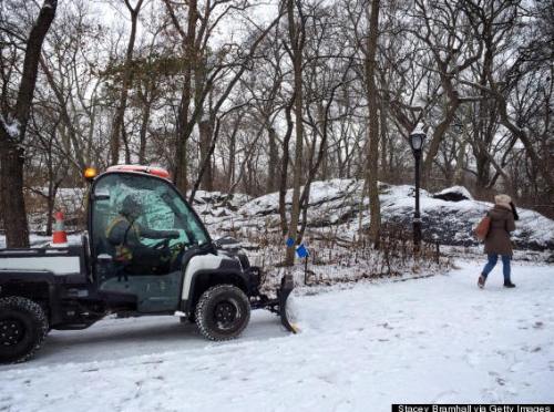 A snowplow follows a pedestrian on a path in New York City’s Central Park. (FILE)
 Wall of snow!


