July 28, 2024
Mohenjo
Business, Enthralling, Human Interest, Photographs
amazon, business, Business News, current-events, Future, Hotels, human-rights, medicine, mental-health, research, Science, Science News, technology, Technology News, travel, vacation

Click the link below the picture
.
Ushuaia is located on Ushuaia Bay at 6 meters above sea level, surrounded to the west, north, and east by the Andes Fueguinos. It is the only city accessed from the rest of the country by crossing part of the Andes mountain range that runs along the southern edge of Tierra del Fuego. National Route 3 crosses the Sierra Alvear through the Garibaldi Pass to enter the Carabajal Valley, where it follows the Olivia River through the Sierra Sorondo to the Beagle Channel and Ushuaia Bay. For this reason, in Argentina, it is considered the only trans-Andean city (ciudad trasandina).
Ushuaia has long been described as the southernmost city in the world. While here are settlements farther south, the only one of any notable size is Puerto Williams, a Chilean settlement of some 2,000 residents. As a center of population, commerce, and culture, and as a town of significant size and importance, Ushuaia however clearly qualifies as a city. A 1998 article in the newspaper Clarín reported that the designation “Southernmost city in the world” had been transferred to Puerto Williams by a joint committee from Argentina and Chile, but this was denied by Argentine authorities, and the Secretariat of Tourism of Argentina continues to use the slogan in official documentation and web sites.
.
 Ushuaia is located on Ushuaia Bay
.
.
Click the link below for the images:
.
__________________________________________
July 22, 2023
Mohenjo
Business, Enthralling, Human Interest, Photographs
amazon, business, Business News, current-events, Future, Hotels, human-rights, medicine, mental-health, research, Science, Science News, technology, Technology News, travel, vacation
Click the link below the picture
.
Kyle of Lochalsh is a village in the historic county of Ross & Cromarty on the northwest coast of Scotland, located around 55 miles west-southwest of Inverness. It is located on the Lochalsh peninsula, at the entrance to Loch Alsh, opposite the village of Kyleakin on the Isle of Skye. Wikipedia
.
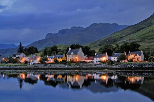 Kyle of Lochalsh, Scotland
.
.
Click the link below for the images:
.
__________________________________________
April 9, 2023
Mohenjo
Business, Food For Thought, Human Interest, Photographs, Political, Science, Technical
amazon, business, Business News, current-events, Future, Hotels, human-rights, medicine, mental-health, research, Science, Science News, technology, Technology News, travel, vacation
 .
.
__________________________________________
February 18, 2023
Mohenjo
Business, Enthralling, Human Interest, Photographs
amazon, business, Business News, current-events, Future, Hotels, human-rights, medicine, mental-health, research, Science, Science News, technology, Technology News, travel, vacation
Click the link below the picture
.
Scenic views Of the sea Against the sky are enthralling!
.
 .
.
.
Click the link below for the images:
.
__________________________________________
February 14, 2023
Mohenjo
Business, Enthralling, Human Interest, Photographs
amazon, business, Business News, current-events, Future, Hotels, human-rights, medicine, mental-health, research, Science, Science News, technology, Technology News, travel, vacation
Click the link below the picture
.
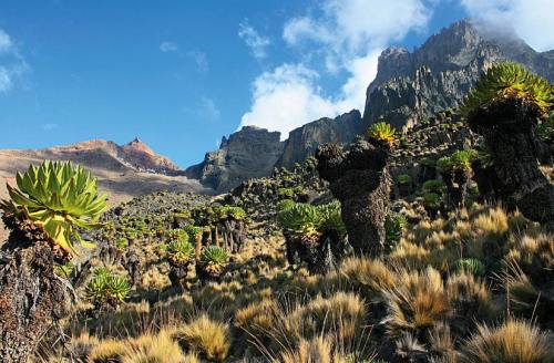
Mount Kenya (Kikuyu: Kĩrĩnyaga, Kamba, Ki Nyaa) is the highest mountain in Kenya and the second-highest in Africa, after Kilimanjaro. The highest peaks of the mountain are Batian (5,199 meters or 17,057 feet), Nelion (5,188 m or 17,021 ft), and Point Lenana (4,985 m or 16,355 ft). Mount Kenya is located in the former Eastern and Central provinces of Kenya; its peak is now the intersection of Meru, Embu, Kirinyaga, Nyeri, and Tharaka Nithi counties, about 16.5 kilometers (10.3 miles) south of the equator, around 150 km (90 mi) north-northeast of the capital Nairobi. Mount Kenya is the source of the name of the Republic of Kenya.
Mount Kenya is a volcano created approximately 3 million years after the opening of the East African Rift. Before glaciation, it was 7,000 m (23,000 ft) high. It was covered by an ice cap for thousands of years. This has resulted in very eroded slopes and numerous valleys radiating from the peak. There are currently 11 small glaciers, which are shrinking rapidly, and may disappear by 2050. The forested slopes are an important source of water for much of Kenya.
There are several vegetation bands from the base to the peak. The lower slopes are covered by different types of forest. Many alpine species are endemic to Mount Kenya, such as the giant lobelias and senecios and a local subspecies of rock hyrax. An area of 715 km2 (276 sq mi) around the center of the mountain was designated a National Park and listed as a UNESCO World Heritage Site in 1997. The park receives over 16,000 visitors per year.
.
.
.
Click the link below for images
.
__________________________________________
February 6, 2023
Mohenjo
Business, Enthralling, Human Interest, Photographs
amazon, business, Business News, current-events, Future, Hotels, human-rights, medicine, mental-health, research, Science, Science News, technology, Technology News, travel, vacation
Click the link below the picture
.
Aiguille du Midi can be called the most popular observation deck of France. It is situated on the peak of the same name in the picturesque Mont Blanc region. This multilevel viewing platform features infrastructure, so the journey to it promises to be an unforgettable adventure. To reach the site you need to overcome an impressive way on the lift and then pass the remaining part of the way by Chamonix Aiguille du Midi cable car. The latter has being operating since 1955 and is still the highest in Europe.
A pleasant surprise will wait for visitors at the top; there you will see a multi-level observation deck with comfortable seating areas and cozy cafes. The open wooden platform acts as a viewing point; it features interconnected tunnels and passages carved directly into the rock. The uppermost area is at an altitude of 3842 meters; it is about 70 meters above the floor.
You can not only walk through the tunnels between levels but also use a special lift that is much more convenient and faster. There is a special plate with the exact height of the platform and its number at each level. It’s also worth to have a long and incredibly interesting tour to Aiguille du Midi that many tourists tend to visit in the summer. The fact is that it’s always very cold and very windy at the top, so it would be more comfortable to climb it in the summer when it’s not so chilly. Wikipedia
.
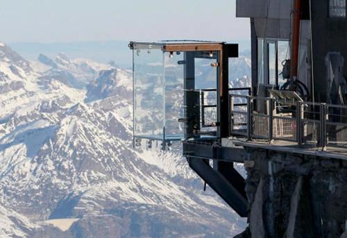
An image of a Viewing platforms at Aiguille du Midi, France
.
.
Click the link below for images:
.
__________________________________________
December 24, 2022
Mohenjo
Business, Enthralling, Human Interest, Photographs
amazon, business, Business News, current-events, Future, Hotels, human-rights, medicine, mental-health, research, Science, Science News, technology, Technology News, travel, vacation
Click the link below the picture
.
Azenhas do Mar is a seaside town (residential neighborhood) in the municipality of Sintra, Portugal. It is part of Colares civil parish. Azenhas do Mar means Watermills of the Sea and the name derives from a once-powerful stream that moved the watermills as it made its way to the sea.
It is located just 30 km (19 mi) away from Lisbon, near Cabo da Roca, Palácio da Pena (Pena Palace), and other attractions.
The place is a Mediterranean-looking village with white houses tumbling down to the Atlantic. In the mid-20th century, wealthy families from Lisbon and Sintra decided that the location was perfect for summer homes, which can be seen outside the main cluster of houses which originally were the homes of a fishing community.
There are a number of popular beaches located near the Azenhas do Mar, namely Praia da Aguda, Praia do Magoito (mostly frequented by locals and surfers), and Praia das Maçãs.
Near Praia das Maçãs there is a Prehistoric Monument, also known as the Tholos of Outeiro das Mós, consists of an artificial Neolithic cave and a Chalcolithic domed or beehive tomb.
.
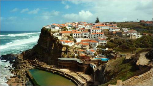 An image of Azenhas Do Mar Portugal
.
.
Click the link below for images:
.
__________________________________________
December 17, 2022
Mohenjo
Business, Enthralling, Human Interest, Photographs
amazon, business, Business News, current-events, Future, Hotels, human-rights, medicine, mental-health, research, Science, Science News, technology, Technology News, travel, vacation

Click the link below the picture
.
Bandhavgarh National Park is a national park of India, located in the Umaria district of Madhya Pradesh. Bandhavgarh, with an area of 105 square kilometers (41 sq mi), was declared a national park in 1968 and then became Tiger Reserve in 1993. The current core area is spread over 716 square kilometers (276 sq mi).
This park has a large biodiversity. The park has a large breeding population of leopards and various species of deer. Maharaja Martand Singh of Rewa captured the first white tiger in this region in 1951. This white tiger, Mohan, is now stuffed and on display in the palace of the Maharajas of Rewa. Historically villagers and their cattle have been at a threat from the tiger. Rising mining activities around the park are putting the tigers at risk. The Park derived its name from the most prominent hill of the area which is said to have been given by Lord Rama to his brother Laxman to keep a watch on Lanka The fort was built by Gond Dynasty king. (Bandhav = Brother, Garh = Fort).[1]
The three main zones of the national park are Tala, Magdhi, and Khitauli. Tala is the richest zone in terms of biodiversity, mainly tigers. Altogether, these three ranges comprise the ‘Core’ of the Bandhavgarh Tiger Reserve constituting a total area of 716 km2.
With the tiger at the apex of the food chain, it contains at least 37 species of mammals. According to forest officials, there are more than 250 species of birds, about 80 species of butterflies, a number of reptiles. But many people have the species’ list of about 350 birds along with photographs. The richness and tranquility of grasslands invites pairs of sarus cranes to breed in the rainy season.
One of the biggest attractions of this national park is the Bengal tiger (Panthera tigris tigris). Bandhavgarh has a very high density of tigers within its jungles. The 105 km2 of park area open to tourists was reported to have 22 tigers, a density of one tiger for every 4.77 km2. (Population estimation exercise 2001). The population of tigers in the park in 2012 was about 44–49. There is a saying about the Park that goes: “In any other Park, you are lucky if you see a tiger. In Bandhavgarh, you are unlucky if you don’t see (at least) one.” Bandhavgarh has one of the highest density of tigers known in the world and is home to some well-known tigers which are large. Charger, a tiger so named because of his habit of charging at elephants and tourists (whom he nonetheless did not harm), was the first healthy male known to be living in Bandhavgarh since the 1990s, as well as a female known as Sita. Charger once appeared on the cover of National Geographic and is considered the second most photographed tiger in the world. Almost all the tigers of Bandhavgarh today are descendants of Sita and Charger. Their daughter Joita, sons Langru and B2 also maintained their tradition for frequent sighting and moving close to tourist vehicles. Mohini, another female, became prominent following Sita’s death. She mated with the male tiger, Mahaman. She later died of her wounds from a vehicle accident. Charger died in 2000 and his body was buried at Charger Point where he was kept in a closed region at his old age. Between 2003 and 2006, many of his descendants met with a series of unfortunate ends. B1 was electrocuted and B3 was killed by poachers. Sita was killed by poachers too. After the death of Charger, the fully grown B2 survived as the dominant male in the forest between 2004 and 2007. Mating with a female in the Siddhababa region of Bandhavgarh, he became father of three cubs. One of them was a male. He was named Bamera. He was first sighted in 2008 and is now Bandhavgarh’s dominant male. In November 2011, B2 died. Postmortem studies suggest that he died a natural death. But some claim that he was injured by the locals from the village in the buffer area. Now, the most prominent tiger in Tala zone of Bandhavgarh National Park is Bamera (died recently). However, of late he has been challenged on several occasions by a new male. Blue Eyes (died recently due to drug overdose) and Mukunda are the dominant males of Magdhi and Khitauli zone respectively. The females who are seen more frequently are Rajbehra, Mirchaini, Banbehi, Mahaman, Sukhi Pattiya, and Damdama. There are quite a few cubs also who are either in sub-adult stage or have entered adulthood and are separate now. Wikipedia
.
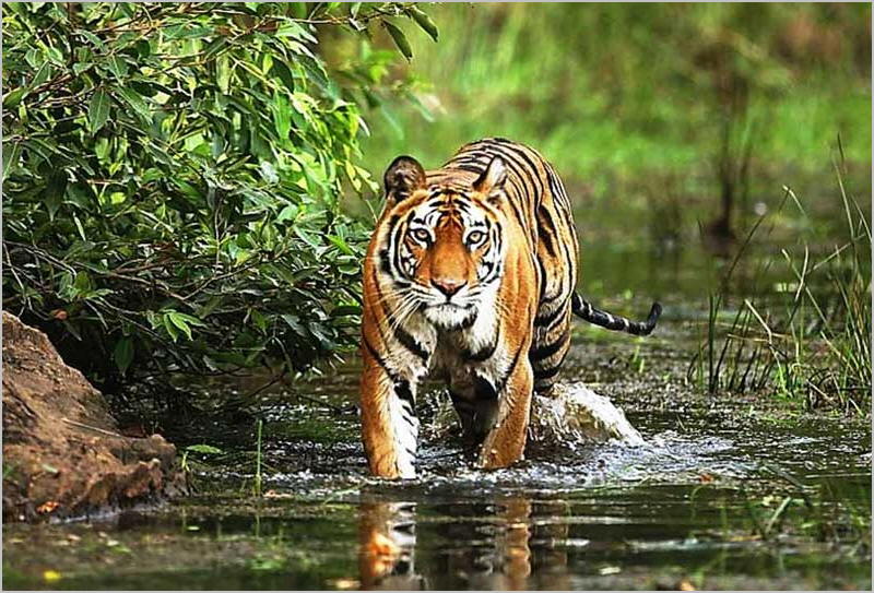 An image from Bandhavgarh National Park India
.
.
Click the link below for images:
.
__________________________________________
December 16, 2022
Mohenjo
Business, Enthralling, Human Interest, Photographs
amazon, business, Business News, current-events, Future, Hotels, human-rights, medicine, mental-health, research, Science, Science News, technology, Technology News, travel, vacation
Click the link below the picture
.
Mauritania, officially the Islamic Republic of Mauritania (Arabic: الجمهورية الإسلامية الموريتانية), is a sovereign country in West Africa. It is bordered by the Atlantic Ocean to the west, Western Sahara to the north and northwest, Algeria to the northeast, Mali to the east and southeast, and Senegal to the southwest. Mauritania is the 11th-largest country in Africa and the 28th-largest in the world, and 90% of its territory is situated in the Sahara. Most of its population of 4.4 million lives in the temperate south of the country, with roughly one-third concentrated in the capital and largest city, Nouakchott, located on the Atlantic coast.
The country’s name derives from the ancient Berber kingdom of Mauretania, located in North Africa within the ancient Maghreb. Berbers occupied what is now Mauritania beginning in the third century AD. Arabs under the Umayyad Caliphate conquered the area in the late seventh century, bringing Islam, Arab culture, and the Arabic language. In the early 20th century, Mauritania was colonized by France as part of French West Africa. It achieved independence in 1960 but has since experienced recurrent coups and periods of military dictatorship. The most recent coup, in 2008, was led by General Mohamed Ould Abdel Aziz, who won subsequent presidential elections in 2009 and 2014.[10] He was succeeded by Mohamed Ould Ghazouani following the 2019 elections, which were considered Mauritania’s first peaceful transition of power since independence.
Mauritania is culturally and politically part of the Arab world: it is a member of the Arab League and Arabic is the sole official language. Reflecting its colonial heritage, French is widely spoken and serves as a lingua franca. The official religion is Islam, and almost all inhabitants are Sunni Muslims. Despite its prevailing Arab identity, Mauritanian society is multiethnic: the Bidhan, or so-called “white moors”, make up 30% of the population, while the Haratin, or so-called “black moors”, comprise 40%. Both groups reflect a fusion of Arab-Berber ethnicity, language, and culture. The remaining 30% of the population comprises various sub-Saharan ethnic groups.
Despite an abundance of natural resources, including iron ore and petroleum, Mauritania remains poor; its economy is based primarily on agriculture, livestock, and fishing. Mauritania is known for its poor human rights record, most notably the continued practice of slavery, a result of a historical caste system between the Bidhan and Haratin. It was the last country in the world to abolish slavery, in 1981 and criminalized it only in 2007.
Mauritania takes its name from the ancient Berber kingdom that flourished beginning in the third century BC and later became the Roman province of Mauretania, which flourished into the seventh century AD. However, the two territories do not overlap: historical Mauretania was considerably further north than modern Mauritania, as it was spread out along the entire western half of the Mediterranean coast of Africa.
.
 An image from Mauritania
.
.
Click the link below for images:
.
__________________________________________
December 10, 2022
Mohenjo
Business, Enthralling, Human Interest, Photographs
amazon, business, Business News, current-events, Future, Hotels, human-rights, medicine, mental-health, research, Science, Science News, technology, Technology News, travel, vacation
Click the link below the picture
.
Mount Shuksan is a glaciated massif in the North Cascades National Park. Shuksan rises in Whatcom County, Washington immediately to the east of Mount Baker, and 11.6 miles (18.7 km) south of the Canada–US border. The mountain’s name Shuksan is derived from the Lummi word [šéqsən], said to mean “high peak”. The highest point on the mountain is a three-sided peak known as Summit Pyramid.
The mountain is composed of Shuksan greenschist, oceanic basalt that was metamorphosed when the Easton terrane collided with the west coast of North America, approximately 120 million years ago. The mountain is an eroded remnant of a thrust plate formed by the Easton collision.
The Mount Baker Highway, State Route 542, is kept open during the winter to support Mt. Baker Ski Area. In late summer, the road to Artist Point allows visitors to travel a few miles higher for a closer view of the peak. Picture Lake is accessible on the highway and reflects the mountain, making it a popular site for photography.
Sulphide Creek Falls, one of the tallest waterfalls in North America, plunges off the southeastern flank of Mount Shuksan. There are four other tall waterfalls that spill off Mount Shuksan and neighboring Jagged Ridge and Seahpo Peak, mostly sourced from small snowfields and glaciers.
The traditional name of Mount Shuksan in the Nooksack language is Shéqsan (“high foot”) or Ch’ésqen (“golden eagle”). Both the Nooksack and Lummi are indigenous tribes who have occupied the watersheds of the Nooksack Rivers and Lummi River, respectively. They are both federally recognized tribes in the United States.
The first ascent of Mount Shuksan is usually attributed to Asahel Curtis and W. Montelius Price on September 7, 1906. However, in a 1907 letter to the editor of the Mazamas club journal, C. E. Rusk attributed the first ascent to Joseph Morowits in 1897. He said that he himself would have attempted it in 1903 if he had not been sure that it had already been climbed.
.
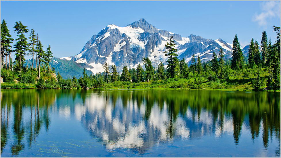 An image from Mount Shuksan in North Cascades National Park, Washington State
.
.
Click the link below for images:
.
__________________________________________
Older Entries

