October 19, 2022
Mohenjo
Business, Enthralling, Human Interest, Photographs
amazon, business, Business News, current-events, Future, Hotels, human-rights, medicine, mental-health, research, Science, Science News, technology, Technology News, travel, vacation

Click the link below the picture
.
Lofoten is an archipelago and a traditional district in the county of Nordland, Norway. Lofoten has distinctive scenery with dramatic mountains and peaks, open sea and sheltered bays, beaches, and untouched lands. There are two towns, Svolvær and Leknes – the latter is approximately 169 km (105 mi) north of the Arctic Circle and approximately 2,420 km (1,500 mi) away from the North Pole. The archipelago experiences one of the world’s largest elevated temperature anomalies relative to its high latitude.
Lofoten (Old Norse: Lófótr) was the original name of the island Vestvågøya. The first element is ló (i.e., “lynx”) and the last element is derived from Norse fótr (i.e., “foot”), as the shape of the island must have been compared with that of a lynx’s foot. (The old name of the neighboring island Flakstadøya was Vargfót, “wolf’s foot”, from vargr “wolf”.) Alternatively, it could derive from the word for light in reference to the presence of Aurora Borealis as the word for light itself is the root of the Old Norse word for lynx lóa, although the earliest evidence suggests Lófótr was first the name of the island of Vestvågøy and only later becoming the name of the chain of islands. Most parsimonious is the analogy with Aurora Borealis, as the word fótr is typically not used to describe the feet of beasts of prey, instead using the word hrammr (paw) or löpp (also paw) for animals such as cats or dogs. Fótr can be used to describe legs, and as such, light leg represents the most plausible etymology taking into account the geography of the archipelago, eventually morphing to describe only the island of Vestvågøy before once again describing the island chain from its main island.
Another name one might come across is “Lofotveggen” or the Lofoten wall. The archipelago looks like a closed wall when seen from elevated points around Bodø or when arriving from the sea, some 100 kilometers (62 miles) long, and 800–1,000 meters (2,600–3,300 feet) high.
“There is evidence of human settlement extending back at least 11,000 years in Lofoten, and the earliest archaeological sites … are only about 5,500 years old, at the transition from the early to late Stone Age.” Iron Age agriculture, livestock, and significant human habitation can be traced back to c. 250 BC.[1]
The town of Vågan (Norse Vágar) is the first known town formation in northern Norway. It existed in the early Viking Age, maybe earlier, and was located on the southern coast on eastern Lofoten, near today’s village Kabelvåg in Vågan municipality. The Lofotr Viking Museum with the reconstructed 83-metre-long (272 ft) longhouse (the largest known) is located near Borg on Vestvågøy, which has many archeological finds from the Iron Age and Viking Age.
The islands have for more than 1,000 years been the center of great cod fisheries, especially in winter, when the cod migrate south from the Barents Sea and gather in Lofoten to spawn. Bergen in southwestern Norway was for a long time the hub for further export of cod south to different parts of Europe, particularly so when trade was controlled by the Hanseatic League. In the lowland areas, particularly Vestvågøy, agriculture plays a significant role, as it has done since the Bronze Age.
In March 1941 the islands were raided by British Commandos during Operation Claymore, and in a subsequent diversionary attack to support the Vaagso raid in December.
As of 2017, the islands attract one million tourists a year. Wikipedia
.
 An image from Reinebringen Lofoten
.
.
Click the link below for images:
.
__________________________________________
October 18, 2022
Mohenjo
Business, Enthralling, Human Interest, Photographs
amazon, business, Business News, current-events, Future, Hotels, human-rights, medicine, mental-health, research, Science, Science News, technology, Technology News, travel, vacation
Click the link below the picture
.
The Maddalena Archipelago is a group of islands in the Strait of Bonifacio between Corsica (France) and Sardinia (Italy). The whole archipelago makes the territory of the La Maddalena comune in Sardinia.
The archipelago consists of seven main islands and numerous small islets. The largest one is the island of La Maddalena (Italian: Isola La Maddalena), with a homonymous town, which is the largest settlement in the archipelago. The other six islands, in order of size, are Caprera, Spargi, Santo Stefano, Santa Maria, Budelli, and Razzoli. Only Maddalena, Caprera, and Santo Stefano are inhabited; Budelli had a single caretaker until 2021.
Lying adjacent to the tourist resort of the Costa Smeralda, Maddalena has the same clear waters and wind-blown granite coastlines but remains a haven for wildlife. It is a designated national park, the Parco Nazionale Arcipelago di La Maddalena. It is a popular tourist destination, especially among boaters. In 2006 it was placed on the tentative list for consideration as a World Heritage Site by UNESCO.
The islands have been inhabited since prehistoric times. They were known by the Romans as Cunicularia and were a busy shipping area during the 2nd and 1st centuries BC. The Maddalenas have a strategic value and were the object of a dispute between the maritime republics of Pisa and Genoa in the 13th century and subsequently was abandoned for a long period before being colonized again by Corsican shepherds and by Sardinian settlements in the 18th century. Napoleon Bonaparte, Admiral Nelson, and Giuseppe Garibaldi all have historical links with the area.
The main access into and out of the archipelago is via the frequent car ferries from Palau on Sardinia that run into La Maddalena. There are roads only on Maddalena and Caprera.
From 1973 until 2008 the Santo Stefano island was a home for the NATO naval base which housed US nuclear submarines. Controversy arose in 2003 when the USS Hartford ran aground in the vicinity of the Bisce Island [it] while on maneuvers in the area. Wikipedia
.
 An image from Maddalena Archipelago
.
.
Click the link below for images:
.
__________________________________________
October 17, 2022
Mohenjo
Business, Enthralling, Human Interest, Photographs
amazon, business, Business News, current-events, Future, Hotels, human-rights, medicine, mental-health, research, Science, Science News, technology, Technology News, travel, vacation
Click the link below the picture
.
The Pragser Wildsee, or Lake Prags, Lake Braies (Italian: Lago di Braies; German: Pragser Wildsee) is a lake in the Prags Dolomites in South Tyrol, Italy. It belongs to the municipality of Prags which is located in the Prags Valley.
During World War II it was the destination of the transport of concentration camp inmates to Tyrol.
In recent years, the lake has earned the nickname “Pearl of the Alps” due to its increasing popularity among tourists.
The name of the lake is attested in 1296 as Hünz an den Se, in 1330 as Praxersee, in 1400 as See in Prags, in 1620 as Pragsersee and in 1885 as Pragser Wildsee; the appellation of wild is therefore nineteenth-century, and perhaps to be connected to mountaineering which in that period began to become a mass phenomenon. The Italian name “Lago di Braies” dates back to 1940, while in the first Handbook of 1923 it still appears only as “Pragser Wildsee”.
The lake lies at the foot of the imposing rock face of the Seekofel (Italian Croda del Becco, Ladin Sass dla Porta 2,810 m) and is located within the Fanes – Sennes – Prags nature park.
It has an extension of about 31 hectares with a length of 1.2 km and a width of 300-400 meters. It is one of the deepest lakes in the autonomous province of Bolzano, with a maximum depth of 36 meters and an average depth of 17. The maximum water temperature is 14 °C. It is a barrage lake, as its creation is due to the barrage of the Prags River due to a landslide detached from the Herrstein.
The lake is a tourist destination, which attracts visitors for the blue/emerald green color of its clear waters and for the natural scenery in which it is immersed. In fact, the lake is surrounded on three sides by Dolomite peaks, including the Seekofel. The lake is the starting point of the Alta via n. 1 of the Dolomites called “The classic” which reaches Belluno at the foot of the Schiara Group.
In recent years, thanks to popularity of the Italian TV series Un passo dal cielo, the Pragser Wildsee became one of the most visited places of the region Trentino-South Tyrol as it started attracting the attention of countless travel bloggers and professional photographers. The large inflow of tourism brought local administrators to think of ways to reduce the number of visits to preserve the mountain-lake ecosystem. Wikipedia
.
 An image from Pragser Wildsee Italy
.
.
Click the link below for images:
.
__________________________________________
October 17, 2022
Mohenjo
Crime, Food For Thought, Human Interest, Medical, missed News, Photographs, Science, sports, Technical
amazon, business, Business News, current-events, Future, Hotels, human-rights, medicine, mental-health, research, Science, Science News, technology, Technology News, travel, vacation

.
News You might have missed!
Use your browser or smartphone back arrow (<-) to return to this table for your next selection.
.
__________________________________________
October 15, 2022
Mohenjo
Business, Enthralling, Human Interest, Photographs
amazon, business, Business News, current-events, Future, Hotels, human-rights, medicine, mental-health, research, Science, Science News, technology, Technology News, travel, vacation

Click the link below the picture
.
British Columbia (BC; French: Colombie-Britannique) is the westernmost province of Canada, situated between the Pacific Ocean and the Rocky Mountains. It has a diverse geography, with rugged landscapes that include rocky coastlines, sandy beaches, forests, lakes, mountains, inland deserts and grassy plains, and borders the province of Alberta to the east and the Yukon and Northwest Territories to the north. With an estimated population of 5.3 million as of 2022, it is Canada’s third-most populous province. The capital of British Columbia is Victoria and its largest city is Vancouver. Vancouver is the third-largest metropolitan area in Canada; the 2021 census recorded 2.6 million people in Metro Vancouver.
The first known human inhabitants of the area settled in British Columbia at least 10,000 years ago. Such groups include the Coast Salish, Tsilhqotʼin, and Haida peoples, among many others. One of the earliest British settlements in the area was Fort Victoria, established in 1843, which gave rise to the city of Victoria, the capital of the Colony of Vancouver Island. Colony of British Columbia (1858–1866) was subsequently founded by Richard Clement Moody, and by the Royal Engineers, Columbia Detachment, in response to the Fraser Canyon Gold Rush. Moody selected the site for and founded the mainland colony’s capital New Westminster. The colonies of Vancouver Island and British Columbia were incorporated in 1866, subsequent to which Victoria became the united colony’s capital. In 1871, British Columbia entered Confederation as the sixth province of Canada, in enactment of the British Columbia Terms of Union.
British Columbia is a diverse and cosmopolitan province, drawing on a plethora of cultural influences from its British Canadians, European, and Asian diasporas, as well as the Indigenous population. Though the province’s ethnic majority originates from the British Isles, many British Columbians also trace their ancestors to continental Europe, East Asia, and South Asia. Indigenous Canadians constitute about 6 percent of the province’s total population. Christianity is the largest religion in the region. English is the common language of the province, although Punjabi, Mandarin Chinese, and Cantonese also have a large presence in the Metro Vancouver region. The Franco-Columbian community is an officially recognized linguistic minority, and around one percent of British, Columbians claim French as their mother tongue. British Columbia is home to at least 34 distinct Indigenous languages.
Major sectors of British Columbia’s economy include forestry, mining, filmmaking and video production, tourism, real estate, construction, wholesale, and retail. Its main exports include lumber and timber, pulp and paper products, copper, coal, and natural gas. British Columbia exhibits high property values and is a significant center for maritime trade: the Port of Vancouver is the largest port in Canada and the most diversified port in North America. Although less than 5 percent of the province’s territory is arable land, significant agriculture exists in the Fraser Valley and Okanagan due to the warmer climate. British Columbia is the fourth-largest province or territory by GDP. British Columbia is home to 45% of all publicly listed companies in Canada.
The province’s name was chosen by Queen Victoria, when the Colony of British Columbia (1858–1866), i.e., “the Mainland”, became a British colony in 1858. It refers to the Columbia District, the British name for the territory drained by the Columbia River, in southeastern British Columbia, which was the namesake of the pre-Oregon Treaty Columbia Department of the Hudson’s Bay Company. Queen Victoria chose British Columbia to distinguish what was the British sector of the Columbia District from the United States (“American Columbia” or “Southern Columbia”), which became the Oregon Territory on August 8, 1848, as a result of the treaty.
Ultimately, the Columbia in the name British Columbia is derived from the name of the Columbia Rediviva, an American ship which lent its name to the Columbia River and later the wider region; the Columbia in the name Columbia Rediviva came from the name Columbia for the New World or parts thereof, a reference to Christopher Columbus. Wikipedia
.
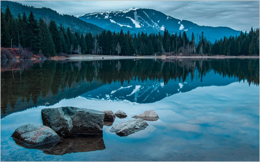 An image of a Canada, British Columbia, Selkirk Mountains. Marmot Lake reflection
.
.
Click the link below for images:
.
__________________________________________
October 14, 2022
Mohenjo
Business, Enthralling, Human Interest, Photographs
amazon, business, Business News, current-events, Future, Hotels, human-rights, medicine, mental-health, research, Science, Science News, technology, Technology News, travel, vacation
Click the link below the picture
.
Budelli is an island in the Maddalena archipelago, near the strait of Bonifacio in northern Sardinia, Italy. It is one of the seven islands that comprise Arcipelago di La Maddalena National Park.
Budelli is several hundred meters south of the islands of Razzoli and Santa Maria. It has an area of 1.6 square kilometers (0.62 sq mi) and a circumference of 12.3 kilometers (7.6 mi). The highest point is Monte Budello, at 87 meters (285 ft).
In antiquity, the Romans used the island. More recently, it was the site of some of the filming for Red Desert, released in 1964. For decades, the island had a series of private owners.
Budelli is especially renowned for its Spiaggia Rosa (Pink Beach), on the southeastern shoreline, which owes its color to microscopic fragments of corals and shells, such as Miriapora truncata and Miniacina miniacea, and was featured in Antonioni’s 1964 film Il deserto rosso (The Red Desert). Budelli was one of four uninhabited islands in the Maddalena archipelago—the others being Caprera, Spargi, and Razzoli. However, from 1989 to 2021, the island had a permanent caretaker, Mauro Morandi, who took over from a married couple.
Rules imposed as of the 1990s by La Maddalena NP have not allowed tourists to walk on the pink beach or swim in the sea; however, day trips by boat, as well as walking along a path behind the beach, were permitted.
In October 2013, the island was to be sold for €2.94 million to New Zealand businessman Michael Harte after the bankruptcy of the previous owner. Harte intended to protect the island’s ecosystem. The government protested, and after a three-year court battle, a judge in Sardinia reverted the island to the state, with the national park planning to use it for environmental education. Wikipedia
.
 An image of Budelli Pink Sand
.
.
Click the link below for images:
.
__________________________________________
October 13, 2022
Mohenjo
Business, Enthralling, Human Interest, Photographs
amazon, business, Business News, current-events, Future, Hotels, human-rights, medicine, mental-health, research, Science, Science News, technology, Technology News, travel, vacation
Click the link below the picture
.
Salisbury Cathedral from the Bishop’s Grounds is an 1823 landscape painting by the nineteenth-century landscape painter John Constable (1776–1837). This image of Salisbury Cathedral, one of England’s most famous medieval churches, is one of his most celebrated works, and was commissioned by one of his closest friends, John Fisher, The Bishop of Salisbury. The 1823 version of the painting has been in the collection of the Victoria & Albert Museum in London, since its bequest in 1857.
Constable visited Salisbury in 1811 and made a series of sketches of the cathedral, from the southeast, the southwest, and from the east end. The artist selected a viewpoint from the bishop’s garden (the southeast) and returned in 1820 to make further drawings and an open-air oil sketch, now in the National Gallery of Canada in Ottawa, which served as the model for the London version. Included in the paintings are figures of Dr. Fisher and his wife at the bottom left. Following the exhibition of the London version at the 1823 Royal Academy, Constable observed: “My Cathedral looks very well….It was the most difficult subject in Landscape I ever had upon my Easel. I have not flinched at the work of the windows, buttresses, &c. – but I have as usual made my escape in the Evanescence of the Chiaro-Oscuro”. His patron took exception to the dark cloud over the cathedral, and when he commissioned a smaller replica, requested “a more serene sky”.
A full-scale replica of the painting also resides at the Frick Collection in New York City. It is slightly different in that it shows different weather and hence light. Whereas the London version depicts the cathedral with an overcast sky, the version in the Frick shows the cathedral with a clear, bright sky. It was executed in 1825 after Fisher requested, in a letter, that Constable repaint the sky in the London version. Unfortunately, Fisher died before Constable completed the work. A full-scale study for the Frick version is currently held at the Metropolitan Museum of Art.
There is an earlier, homonymous version (1821–1822) of this painting at São Paulo Museum of Art in São Paulo. This is an early oil sketch for the London version.
Another, small version of the painting, measuring 62.9 × 75.9 cm, executed between 1823 and 1826, now resides at the Huntington Library in San Marino, California. This smaller, sunnier version was painted for John Fisher as a wedding present for his daughter, Elizabeth.
Constable painted many views of Salisbury Cathedral during his career, including Salisbury Cathedral and Leadenhall from the River Avon (1820) and more famously Salisbury Cathedral from the Meadows (1831). Wikipedia
.
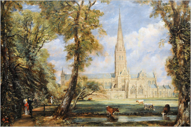 An image of Salisbury Cathedral From The Bishop’s Grounds John Constable
.
.
Click the link below for images:
.
__________________________________________
October 12, 2022
Mohenjo
Business, Enthralling, Human Interest, Photographs
amazon, business, Business News, current-events, Future, Hotels, human-rights, medicine, mental-health, research, Science, Science News, technology, Technology News, travel, vacation
Click the link below the picture
.
The white rhinoceros, white rhino or square-lipped rhinoceros (Ceratotherium simum) is the largest extant species of rhinoceros. It has a wide mouth used for grazing and is the most social of all rhino species. The white rhinoceros consists of two subspecies: the southern white rhinoceros, with an estimated 19,682–21,077 wild-living animals in the year 2015, and the much rarer northern white rhinoceros. The northern subspecies has very few remaining individuals, with only two confirmed left in 2018 (two females: Fatu, 18, and Najin, 29), both in captivity. Sudan, the world’s last known male northern white rhinoceros, died in Kenya on 19 March 2018.
Popular albeit widely discredited theory of the origins of the name “white rhinoceros” is a mistranslation from Dutch to English. The English word “white” is said to have been derived by mistranslation of the Dutch word “wijd”, which means “wide” in English. The word “wide” refers to the width of the rhinoceros’ mouth. So early English-speaking settlers in South Africa misinterpreted the “wijd” for “white” and the rhino with the wide mouth ended up being called the white rhino and the other one, with the narrow pointed mouth, was called the black rhinoceros. Ironically, Dutch (and Afrikaans) later used a calque of the English word, and now also call it a white rhino. This suggests the origin of the word was before codification by Dutch writers. A review of Dutch and Afrikaans literature about the rhinoceros has failed to produce any evidence that the word wijd was ever used to describe the rhino outside of oral use.
An alternative name for the white rhinoceros, more accurate but rarely used, is the square-lipped rhinoceros. The white rhinoceros’ generic name, Ceratotherium, given by the zoologist John Edward Gray in 1868, is derived from the Greek terms keras (κέρας) “horn” and thērion (θηρίον) “beast”. Simum is derived from the Greek term simos (σιμός), meaning “flat-nosed”.
The white rhinoceros of today was said to be likely descended from Ceratotherium praecox which lived around 7 million years ago. Remains of this white rhino have been found at Langebaanweg near Cape Town. A review of fossil rhinos in Africa by Denis Geraads has however suggested that the species from Langebaanweg is of the genus Ceratotherium, but not Ceratotherium praecox as the type specimen of Ceratotherium praecox should, in fact, be Diceros praecox, as it shows closer affinities with the black rhinoceros Diceros bicornis. It has been suggested that the modern white rhino has a longer skull than Ceratotherium praecox to facilitate consumption of shorter grasses which resulted from the long-term trend to drier conditions in Africa. However, if Ceratotherium praecox is in fact Diceros praecox, then the shorter skull could indicate a browsing species. Teeth of fossils assigned to Ceratotherium found at Makapansgat in South Africa were analyzed for carbon isotopes and the researchers concluded that these animals consumed more than 30% browse in their diet, suggesting that these are not the fossils of the extant Ceratotherium simum which only eats grass. It is suggested that the real lineage of the white rhino should be; Ceratotherium neumayri → Ceratotherium mauritanicum → C. simum with the Langebaanweg rhinos being Ceratotherium sp. (as yet unnamed), with black rhinos being descended from C. neumayri via Diceros praecox.
Recently, an alternative scenario has been proposed under which the earliest African Ceratotherium is considered to be Ceratotherium efficax (now synonymous with C. mauritanicum), known from the Late Pliocene of Ethiopia and the Early Pleistocene of Tanzania. This species is proposed to have been diversified into the Middle Pleistocene species C. mauritanicum in northern Africa, C. germanoafricanum in East Africa, and the extant C. simum. The first two of these are extinct, however, C. germanoafricanum is very similar to C. simum and has often been considered a fossil and ancestral subspecies to the latter. The study also doubts the ancestry of C. neumayri from the Miocene of southern Europe to the African species. The ancestor of both the black and the white rhinos was likely a mixed feeder, with the two lineages then specializing in browsing and grazing, respectively. The oldest definitive record of the White Rhinoceros is during the mid-Early Pleistocene at Olduvai Gorge in Tanzania, around 1.8 Ma. Wikipedia
.
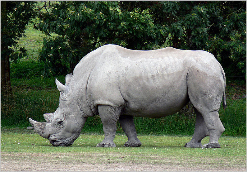 An image of a White Rhinoceros
.
.
Click the link below for images:
.
__________________________________________
October 11, 2022
Mohenjo
Business, Enthralling, Human Interest, Photographs
amazon, business, Business News, current-events, Future, Hotels, human-rights, medicine, mental-health, research, Science, Science News, technology, Technology News, travel, vacation
Click the link below the picture
.
Eilean Donan is a small tidal island situated at the confluence of three sea lochs (Loch Duich, Loch Long, and Loch Alsh) in the western Highlands of Scotland, about 1 kilometer (5⁄8 mi) from the village of Dornie. It is connected to the mainland by a footbridge that was installed early in the 20th century and is dominated by a picturesque castle that frequently appears in photographs, film, and television. The island’s original castle was built in the thirteenth century; it became a stronghold of the Clan Mackenzie and their allies, the Clan MacRae. However, in response to the Mackenzies’ involvement in the Jacobite rebellions early in the 18th century, government ships destroyed the castle in 1719. The present-day castle is Lieutenant-Colonel John Macrae-Gilstrap’s 20th-century reconstruction of the old castle.
Eilean Donan is part of the Kintail National Scenic Area, one of 40 in Scotland. In 2001, the island had a recorded population of just one person, but there were no “usual residents” at the time of the 2011 census. Eilean Donan, which means simply “island of Donnán”, is named after Donnán of Eigg, a Celtic saint who was martyred in 617. Donnán is said to have established a church on the island, though no trace of this remains.
It is possible that an early Christian monastic cell was founded on the island in the 6th or 7th century, and that it was dedicated to Donnán of Eigg, an Irish saint who was martyred on Eigg in April 617. No remains of any Christian buildings survive, though fragments of vitrified stone (stone that has been subjected to very high temperatures) have been discovered, indicating that there was an Iron Age or early medieval fortification on the island.
In the earlier thirteenth century, during the reign of Alexander II (ruled 1214–1249), a large curtain-wall castle (wall of enceinte) was constructed; it enclosed much of the island. At this time, the area around the island was at the boundary of the Norse-Celtic Lordship of the Isles and the Earldom of Ross: Eilean Donan provided a strong defensive position against Norse expeditions. A founding legend has it that the son of a chief of the Mathesons acquired the power to communicate with birds; as a result of this power, and after many adventures overseas, he gained wealth, power, and the respect of Alexander II, who asked him to build the castle to defend his realm.
At a later date, the island became a stronghold of the Mackenzies of Kintail, originally vassals of William I, Earl of Ross. At this early stage, the castle is said to have been garrisoned by Macraes and Maclennans, both clans that were later closely associated with the Mackenzies Traditional Mackenzie clan histories relate that Earl William sought advantage from the Treaty of Perth of 1266, by which King Magnus VI of Norway ceded the Hebrides to Scotland, and demanded that his kinsman Kenneth Mackenzie return the castle to allow his expansion into the islands. Mackenzie refused, and Earl William led an assault against Eilean Donan that the Mackenzies and their allies repulsed.
The Mackenzie clan histories also claim (with little, if any, supporting contemporary evidence), that Robert the Bruce sheltered at Eilean Donan during the winter of 1306 to 1307; the castle escaped any other involvement in the Wars of Scottish Independence. In 1331 Thomas Randolph, Earl of Moray, sent an officer to Eilean Donan to warn the occupants of his forthcoming visit. In preparation 50 wrongdoers were rounded up and executed, their heads being displayed on the castle walls to Moray’s approval. By the middle of the 14th century, the Mackenzies are said to have been on the losing side in the ongoing feuding with the Earls of Ross. William III, Earl of Ross granted Kintail to Raghnall Mac Ruaidhrí in 1342. With the assistance of Leod Macgilleandrais, the Earl allegedly apprehended Kenneth Mackenzie, 3rd of Kintail, and had him executed in 1346 at Inverness. Through this period Eilean Donan is said to have been held by Duncan Macaulay for the Mackenzies, against the Earl and his allies. Kenneth’s young son Murdo Mackenzie supposedly evaded the Earl’s attempts to eliminate him, and on the return of David II from exile Murdo Mackenzie was allegedly confirmed in the lands of Kintail and Eilean Donan by a charter of 1362 (of which, however, no trace survives to the present day). At some point in the earlier 14th century, it is thought that the Clan Macrae began to settle in Kintail as a body, having migrated from the Beauly Firth, and there gained the trust of the Mackenzie lairds through possible kinship and an advantageous marriage. The Macraes began to act as Mackenzie’s bodyguards, acquiring the soubriquet “Mackenzie’s shirt of mail”. Wikipedia
.
 An image of Eilean Donan Castle
.
.
Click the link below for images:
.
__________________________________________
October 10, 2022
Mohenjo
Business, Enthralling, Human Interest, Photographs
amazon, business, Business News, current-events, Future, Hotels, human-rights, medicine, mental-health, research, Science, Science News, technology, Technology News, travel, vacation
Click the link below the picture
.
Ilkley Moor is part of Rombalds Moor, the moorland between Ilkley and Keighley in West Yorkshire, England. The moor, which rises to 402 m (1,319 ft) above sea level, is well known as the inspiration for the Yorkshire “county anthem” On Ilkla Moor Baht ‘at (dialect for ‘on Ilkley Moor without a hat’).
During the Carboniferous period (325 million years ago), Ilkley Moor was part of a sea-level swampy area fed by meandering river channels coming from the north. The layers in the eroded bank faces of stream gullies in the area represent sea levels with various tides depositing different sorts of sediment. Over a long period of time, the sediments were cemented and compacted into hard rock layers. Geological forces lifted and tilted the strata a little towards the southeast, producing many small fractures, or faults. Since the end of the Carboniferous period more than a thousand meters of the coal-bearing rocks have been completely removed from the area by erosion. During the last million years, Ice Age glaciers modified the shape of the Wharfe valley, deepening it, smoothing it, and leaving behind glacial debris. The millstone grit not only gives character to the town of Ilkley but gives the area its acid soils, heather moors, soft water, and rocky scars. Wikipedia
.
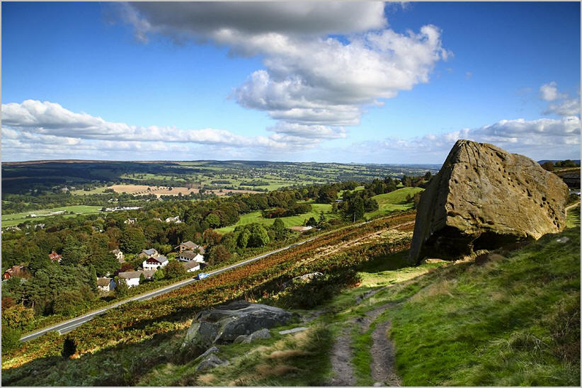 An image from Ilkley Moor Yorkshire
.
.
Click the link below for images:
.
__________________________________________
Older Entries
Newer Entries
