April 4, 2022
Mohenjo
Business, Enthralling, Human Interest, Photographs
amazon, business, Business News, current-events, Future, Hotels, human-rights, medicine, mental-health, research, Science, Science News, technology, Technology News, travel, vacation

Click the link below the picture
.
Brazil officially the Federative Republic of Brazil is the largest country in both South America and Latin America. At 8.5 million square kilometers (3,300,000 sq mi) and with over 211 million people, Brazil is the world’s fifth-largest country by area and the sixth-most populous. Its capital is Brasília, and its most populous city is São Paulo. The federation is composed of the union of the 26 states and the Federal District. It is the largest country to have Portuguese as an official language and the only one in the Americas; it is also one of the most multicultural and ethnically diverse nations, due to over a century of mass immigration from around the world; as well as the most populous Roman Catholic-majority country.
Bounded by the Atlantic Ocean on the east, Brazil has a coastline of 7,491 kilometers (4,655 mi). It borders all other countries in South America except Ecuador and Chile and covers 47.3% of the continent’s land area. Its Amazon basin includes a vast tropical forest, home to diverse wildlife, a variety of ecological systems, and extensive natural resources spanning numerous protected habitats. This unique environmental heritage makes Brazil one of 17 megadiverse countries, and is the subject of significant global interest, as environmental degradation through processes like deforestation has direct impacts on global issues like climate change and biodiversity loss.
Brazil was inhabited by numerous tribal nations prior to the landing in 1500 of explorer Pedro Álvares Cabral, who claimed the area for the Portuguese Empire. Brazil remained a Portuguese colony until 1808 when the capital of the empire was transferred from Lisbon to Rio de Janeiro. In 1815, the colony was elevated to the rank of kingdom upon the formation of the United Kingdom of Portugal, Brazil, and the Algarves. Independence was achieved in 1822 with the creation of the Empire of Brazil, a unitary state governed under a constitutional monarchy and a parliamentary system. The ratification of the first constitution in 1824 led to the formation of a bicameral legislature, now called the National Congress. The country became a presidential republic in 1889 following a military coup d’état. An authoritarian military junta came to power in 1964 and ruled until 1985, after which civilian governance resumed. Brazil’s current constitution, formulated in 1988, defines it as a democratic federal republic. Due to its rich culture and history, the country ranks thirteenth in the world by number of UNESCO World Heritage Sites.
Brazil is a regional and middle power and is also classified as an emerging power. It is considered an advanced emerging economy, having the twelfth largest GDP in the world by nominal, and eighth by PPP measures. As an upper-middle-income economy by the World Bank and a newly industrialized country, Brazil has the largest share of global wealth in South America and it is one of the world’s major breadbaskets, being the largest producer of coffee for the last 150 years. However, the country maintains noticeable amounts of corruption, crime, and social inequality. Brazil is a founding member of the United Nations, the G20, BRICS, Mercosul, Organization of American States, Organization of Ibero-American States, and the Community of Portuguese Language Countries. Wikipedia
.
 An image from Brazilian Places
.
.
Click the link below for images:
.
__________________________________________
April 2, 2022
Mohenjo
Business, Enthralling, Human Interest, Photographs
amazon, business, Business News, current-events, Future, Hotels, human-rights, medicine, mental-health, research, Science, Science News, technology, Technology News, travel, vacation
Click the link below the picture
.
Lake Garda is the largest lake in Italy. It is a popular holiday location in northern Italy, about halfway between Brescia and Verona, and between Venice and Milan on the edge of the Dolomites. Glaciers formed this alpine region at the end of the last ice age. The lake and its shoreline are divided between the provinces of Verona (to the south-east), Brescia (south-west), and Trentino (north). The name Garda, which the lake has been referred to in documents dating to the 8th century, comes from the town of the same name. It is evolved from the Germanic word warda, meaning “place of guard”, “place of observation” or “place of safety”.
The northern part of the lake is narrower, surrounded by mountains, the majority of which belong to the Gruppo del Baldo. The shape is typical of a moraine valley, probably having been formed under the action of a Paleolithic glacier. Although traces of the glacier’s actions are evident today, in more recent years it has been hypothesized that the glacier occupied a previously existing depression, created by stream erosion 5 to 6 million years ago.
The lake has numerous small islands and five main ones, the largest being Isola del Garda, where, in 1220 St. Francis of Assisi founded a monastery. In its place now stands a 19th-century building in the Venetian Gothic style. Nearby to the south is Isola San Biagio, also known as the Isola dei Conigli (“Island of the Rabbits”). Both are offshore of San Felice del Benaco, on the lake’s western side. The three other main islands are Isola dell’Olivo, Isola di Sogno, and Isola di Trimelone, all farther north near the eastern side. The main tributary is the Sarca River, others include the Ponale River (fed by Lago di Ledro), the Varone/Magnone River (via the Cascate del Varone), and various streams from both mountainsides, while the only outlet is the Mincio River (79 meters (259 ft), at Peschiera). The subdivision is created by the presence of a fault submerged between Sirmione and Punta San Vigilio which is almost a natural barrier that hampers the homogenization between the water of the two zones.
If the water level of the Adige river is excessive, water is diverted to the lake through the Mori-Torbole tunnel. Wikipedia
.
 An image of Garda Lake, Italy
.
.
Click the link below for images:
.
__________________________________________
April 1, 2022
Mohenjo
Business, Enthralling, Human Interest, Photographs
amazon, business, Business News, current-events, Future, Hotels, human-rights, medicine, mental-health, research, Science, Science News, technology, Technology News, travel, vacation
Click the link below the picture
.
The Czech Republic, also known as Czechia and historically known as Bohemia, is a landlocked country in Central Europe. It is bordered by Austria to the south, Germany to the west, Poland to the northeast, and Slovakia to the southeast. The Czech Republic has a hilly landscape that covers an area of 78,871 square kilometers (30,452 sq mi) with a mostly temperate continental and oceanic climate. The capital and largest city is Prague; other major cities and urban areas include Brno, Ostrava, Plzeň, and Liberec.
The Duchy of Bohemia was founded in the late 9th century under Great Moravia. It was formally recognized as an Imperial State of the Holy Roman Empire in 1002 and became a kingdom in 1198. Following the Battle of Mohács in 1526, the whole Crown of Bohemia was gradually integrated into the Habsburg Monarchy. The Protestant Bohemian Revolt led to the Thirty Years’ War. After the Battle of the White Mountain, the Habsburgs consolidated their rule. With the dissolution of the Holy Empire in 1806, the Crown lands became part of the Austrian Empire.
In the 19th century, the Czech lands became more industrialized, and in 1918 most of it became part of the First Czechoslovak Republic following the collapse of Austria-Hungary after World War I. Czechoslovakia was the only country in Central and Eastern Europe to remain a parliamentary democracy during the entirety of the interwar period. After the Munich Agreement in 1938, Nazi Germany systematically took control over the Czech lands. Czechoslovakia was restored in 1945 and became an Eastern Bloc communist state following a coup d’état in 1948. Attempts at a liberalization of the government and economy were suppressed by a Soviet-led invasion of the country during the Prague Spring in 1968. In November 1989, the Velvet Revolution ended Communist rule in the country, and on 1 January 1993, Czechoslovakia was dissolved, with its constituent states becoming the independent states of the Czech Republic and Slovakia.
The Czech Republic is a unitary parliamentary republic and developed country with an advanced, high-income social market economy. It is a welfare state with a European social model, universal health care, and tuition-free university education. It ranks 12th in the UN inequality-adjusted human development and 24th in the World Bank Human Capital Index. It ranks as the 9th safest and most peaceful country and 31st in democratic governance. The Czech Republic is a member of NATO, the European Union, OECD, OSCE, and the Council of Europe. Wikipedia
.
 An image from Czech Republic
.
.
Click the link below for images:
.
__________________________________________
March 31, 2022
Mohenjo
Business, Enthralling, Human Interest, Photographs
amazon, business, Business News, current-events, Future, Hotels, human-rights, medicine, mental-health, research, Science, Science News, technology, Technology News, travel, vacation
Click the link below the picture
.
Villasimius is a comune (municipality) in the Province of South Sardinia in the Italian region of Sardinia, located about 35 kilometers (22 mi) east of Cagliari.
Due to its strategically important site, Villasimius’ territory was inhabited since prehistoric times, as testified by nuraghe (19th-6th centuries BC), Phoenician-Carthaginian (7th-2nd centuries BC), and Roman (3rd-century BC-6th century AD) remains.
During the giudicati (Sardinian kingdoms), Aragonese and Spanish reigns, the territory suffered numerous pirate raids and became increasingly depopulated. The village name was, at least from the 13th century, Carbonara; this was repopulated from the early 19th century, when it was under the Kingdom of Sardinia-Piedmont, becoming a commune in 1838. Villasimius’ economy was traditionally based on agriculture and shepherding and, from 1875 to the extraction of granite. Its tourism industry began in the late 1960s and is now Villasimius’ main economic activity.
In 1998 the Capo Carbonara National Marine Park was created. It encompasses all the waters surrounding the headlands in the eastern Gulf of Cagliari, from Villasimius’ western border with Solanas to its northern border with Castiadas.
Most important beaches [1] of the area are Cala Burroni, Cala Caterina, Campus, Piscadeddus, Porto Giunco, Porto Sa Ruxi, Punta Molentis, Simius, Spiaggia del Riso, Timi Ama. Wikipedia
.
 An image from Villasimius
.
.
Click the link below for images:
.
__________________________________________
March 30, 2022
Mohenjo
Business, Enthralling, Human Interest, Photographs
amazon, business, Business News, current-events, Future, Hotels, human-rights, medicine, mental-health, research, Science, Science News, technology, Technology News, travel, vacation
Click the link below the picture
.
Brunei is a country located on the north coast of the island of Borneo in Southeast Asia. Apart from its South China Sea coast, it is completely surrounded by the Malaysian state of Sarawak. It is separated into two parts by the Sarawak district of Limbang. Brunei is the only sovereign state entirely on Borneo; the remainder of the island is divided between Malaysia and Indonesia. As of 2020, its population was 460,345, of whom about 100,000 live in the capital and largest city, Bandar Seri Begawan. The government is an absolute monarchy ruled by its Sultan, entitled the Yang di-Pertuan, and implements a combination of English common law and sharia law, as well as general Islamic practices.
At the peak of the Bruneian Empire, Sultan Bolkiah (reigned 1485–1528) is claimed to have had control over most regions of Borneo, including modern-day Sarawak and Sabah, as well as the Sulu Archipelago off the northeast tip of Borneo, and the islands off the northwest tip of Borneo. Claims also state that they had control over Seludong (or the Kingdom of Maynila, where the modern-day Philippine capital Manila now stands) but Southeast Asian scholars believe this refers to a settlement Mount Selurong in Indonesia. The maritime state of Brunei was visited by Spain’s Magellan Expedition in 1521 and fought against Spain in the 1578 Castilian War.
During the 19th century, the Bruneian Empire began to decline. The Sultanate ceded Sarawak (Kuching) to James Brooke and installed him as the White Rajah, and it ceded Sabah to the British North Borneo Chartered Company. In 1888, Brunei became a British protectorate and was assigned a British resident as colonial manager in 1906. After the Japanese occupation during World War II, in 1959 a new constitution was written. In 1962, a small armed rebellion against the monarchy was ended with the help of the British.
Brunei gained its independence from the United Kingdom on 1 January 1984. Economic growth during the 1990s and 2000s, with the GDP increasing 56% from 1999 to 2008, transformed Brunei into an industrialized country. It has developed wealth from extensive petroleum and natural gas fields. Brunei has the second-highest Human Development Index among the Southeast Asian nations, after Singapore, and is classified as a developed country. According to the International Monetary Fund (IMF), Brunei is ranked fifth in the world by gross domestic product per capita at purchasing power parity. The IMF estimated in 2011 that Brunei was one of two countries (the other being Libya) with a public debt at 0% of the national GDP. Wikipedia
.
 An image from Brunei
.
.
Click the link below for images:
.
__________________________________________
March 30, 2022
Mohenjo
Business, Enthralling, Food For Thought, Human Interest, Overlooked Past Article, Science, Technical
amazon, business, Business News, current-events, Future, Hotels, human-rights, medicine, mental-health, research, Science, Science News, technology, Technology News, travel, vacation

Click the link below the picture
.
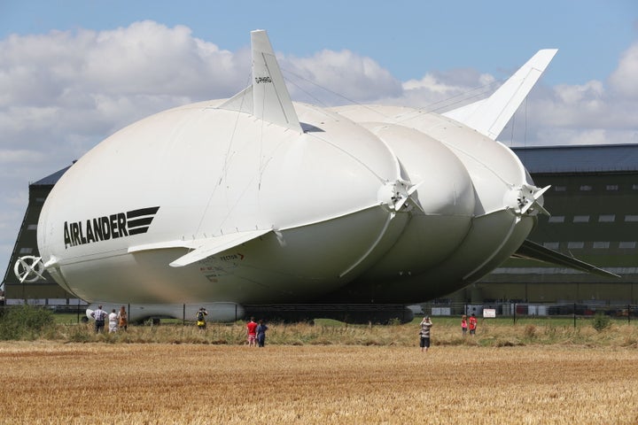
The world’s longest aircraft was brought out of its hangar in England over the weekend. But the first thing most people noticed about the Airlander 10, besides its enormous size, was that its front looked like a huge behind.
It’s even been nicknamed “The Flying Bum” by the British media, and photos like this probably don’t help:
At 302 feet long, the Airlander 10 is 50 feet longer than the largest configuration of the Boeing 747.
The airship was originally developed by the U.S. Army for surveillance; however, the project was picked up by Hybrid Air Vehicles in 2013 after funding ran out.
Once it proves safe to fly, the airship could be used for surveillance, cargo, communications, humanitarian missions and passenger travel, the BBC reported.
The airship was officially named the Martha Gwyn, after the wife of Hybrid Air Vehicles chairman Philip Gwyn, according to the Daily Telegraph. It’s filled with 1.3 million cubic feet of helium, and is expected to reach an altitude of 20,000 feet and fly for up to five days at speeds of 90 mph.
Here’s the aircraft ― part blimp, part plane ― at Cardington Airfield:
An overlooked past article
.
 Chris Radburn/PA Wire
.
.
Click the link below for the article:
.
__________________________________________
March 29, 2022
Mohenjo
Business, Enthralling, Human Interest, Photographs
amazon, business, Business News, current-events, Future, Hotels, human-rights, medicine, mental-health, research, Science, Science News, technology, Technology News, travel, vacation
Click the link below the picture
.
Sardinia is the second-largest island in the Mediterranean Sea, after Sicily, and one of the 20 regions of Italy. It is located west of the Italian Peninsula, north of Tunisia, and immediately south of the French island of Corsica.
It is one of the five Italian regions with some degree of domestic autonomy being granted by a special statute. Its official name, Autonomous Region of Sardinia, is bilingual in Italian and Sardinian: Regione Autonoma della Sardegna / Regione Autònoma de Sardigna. It is divided into four provinces and a metropolitan city. The capital of the region of Sardinia — and its largest city — is Cagliari.
Sardinia’s indigenous language and Algherese Catalan are referred to by both the regional and national law as two of Italy’s twelve officially recognized linguistic minorities, albeit gravely endangered, while the regional law provides some measures to recognize and protect the aforementioned as well as the island’s other minority languages (the Corsican-influenced Sassarese and Gallurese, and finally Tabarchino Ligurian).
Owing to the variety of Sardinia’s ecosystems, which include mountains, woods, plains, stretches of largely uninhabited territory, streams, rocky coasts, and long sandy beaches, Sardinia has been metaphorically described as a micro-continent. In the modern era, many travelers and writers have extolled the beauty of its long-untouched landscapes, which retain vestiges of the Nuragic civilization.
The name Sardinia has pre-Latin roots. It comes from the pre-Roman ethnonym *s(a)rd-, later romanized as sardus (feminine sarda). It makes its first appearance on the Nora Stone, where the word ŠRDN, or *Šardana, testifies to the name’s existence when the Phoenician merchants first arrived. Wikipedia
.
 An image from Punta Molentis Sardinia
.
.
Click the link below for images:
.
__________________________________________
March 28, 2022
Mohenjo
Business, Enthralling, Human Interest, Photographs
amazon, business, Business News, current-events, Future, Hotels, human-rights, medicine, mental-health, research, Science, Science News, technology, Technology News, travel, vacation
Click the link below the picture
.
India, officially the Republic of India is a country in South Asia. It is the seventh-largest country by area, the second-most populous country, and the most populous democracy in the world. Bounded by the Indian Ocean on the south, the Arabian Sea on the southwest, and the Bay of Bengal on the southeast, it shares land borders with Pakistan to the west; China, Nepal, and Bhutan to the north; and Bangladesh and Myanmar to the east. In the Indian Ocean, India is in the vicinity of Sri Lanka and the Maldives; its Andaman and Nicobar Islands share a maritime border with Thailand, Myanmar, and Indonesia.
Modern humans arrived on the Indian subcontinent from Africa no later than 55,000 years ago. Their long occupation, initially in varying forms of isolation as hunter-gatherers, has made the region highly diverse, second only to Africa in human genetic diversity. Settled life emerged on the subcontinent in the western margins of the Indus river basin 9,000 years ago, evolving gradually into the Indus Valley Civilisation of the third millennium BCE. By 1200 BCE, an archaic form of Sanskrit, an Indo-European language, had diffused into India from the northwest, unfolding as the language of the Rigveda, and recording the dawning of Hinduism in India. The Dravidian languages of India were supplanted in the northern and western regions. By 400 BCE, stratification and exclusion by caste had emerged within Hinduism, and Buddhism and Jainism had arisen, proclaiming social orders unlinked to heredity. Early political consolidations gave rise to the loose-knit Maurya and Gupta Empires based in the Ganges Basin. Their collective era was suffused with wide-ranging creativity but also marked by the declining status of women, and the incorporation of untouchability into an organized system of belief. In South India, the Middle kingdoms exported Dravidian languages scripts and religious cultures to the kingdoms of Southeast Asia.
In the early medieval era, Christianity, Islam, Judaism, and Zoroastrianism put down roots on India’s southern and western coasts. Muslim armies from Central Asia intermittently overran India’s northern plains, eventually establishing the Delhi Sultanate, and drawing northern India into the cosmopolitan networks of medieval Islam. In the 15th century, the Vijayanagara Empire created a long-lasting composite Hindu culture in south India. In the Punjab, Sikhism emerged, rejecting institutionalized religion. The Mughal Empire, in 1526, ushered in two centuries of relative peace, leaving a legacy of luminous architecture. Gradually expanding rule of the British East India Company followed, turning India into a colonial economy, but also consolidating its sovereignty. British Crown rule began in 1858. The rights promised to Indians were granted slowly, but technological changes were introduced, and ideas of education, modernity, and the public life took root. A pioneering and influential nationalist movement emerged, which was noted for nonviolent resistance and became the major factor in ending British rule. In 1947 the British Indian Empire was partitioned into two independent dominions, a Hindu-majority Dominion of India and a Muslim-majority Dominion of Pakistan, amid large-scale loss of life and an unprecedented migration.
India has been a federal republic since 1950, governed in a democratic parliamentary system. It is a pluralistic, multilingual, and multi-ethnic society. India’s population grew from 361 million in 1951 to 1.211 billion in 2011. During the same time, its nominal per capita income increased from US$64 annually to US$1,498, and its literacy rate from 16.6% to 74%. From being a comparatively destitute country in 1951, India has become a fast-growing major economy and a hub for information technology services, with an expanding middle class. It has a space program that includes several planned or completed extraterrestrial missions. Indian movies, music, and spiritual teachings play an increasing role in global culture. India has substantially reduced its rate of poverty, though at the cost of increasing economic inequality. India is a nuclear-weapon state, which ranks high in military expenditure. It has disputes over Kashmir with its neighbors, Pakistan and China, unresolved since the mid-20th century. Among the socio-economic challenges, India faces gender inequality, child malnutrition, and rising levels of air pollution. India’s land is megadiverse, with four biodiversity hotspots. Its forest cover comprises 21.7% of its area. India’s wildlife, which has traditionally been viewed with tolerance in India’s culture, is supported among these forests, and elsewhere, in protected habitats. Wikipedia
.
 An image from India
.
.
Click the link below for images:
.
__________________________________________
March 26, 2022
Mohenjo
Business, Enthralling, Human Interest, Photographs
amazon, business, Business News, current-events, Future, Hotels, human-rights, medicine, mental-health, research, Science, Science News, technology, Technology News, travel, vacation
Click the link below the picture
.
Denali National Park and Preserve, formerly known as Mount McKinley National Park, is an American national park and preserve located in Interior Alaska, centered on Denali, the highest mountain in North America. The park and contiguous preserve encompass 6,045,153 acres (9,446 sq mi; 24,464 km2) which is larger than the state of New Hampshire. On December 2, 1980, 2,146,580-acre (3,354 sq mi; 8,687 km2) Denali Wilderness was established within the park. Denali’s landscape is a mix of forest at the lowest elevations, including deciduous taiga, with tundra at middle elevations, and glaciers, snow, and bare rock at the highest elevations. The longest glacier is the Kahiltna Glacier. Wintertime activities include dog sledding, cross-country skiing, and snowmobiling. The park received 594,660 recreational visitors in 2018.
Human habitation in the Denali Region extends to more than 11,000 years before the present, with documented sites just outside park boundaries dated to more than 8,000 years before present. However, relatively few archaeological sites have been documented within the park boundaries, owing to the region’s high elevation, with harsh winter conditions and scarce resources compared to lower elevations in the area. The oldest site within park boundaries is the Teklanika River site, dated to about 7130 BC. More than 84 archaeological sites have been documented within the park. The sites are typically characterized as hunting camps rather than settlements and provide little cultural context. The presence of Athabaskan peoples in the region is dated to 1,500 – 1,000 years before present on linguistic and archaeological evidence, while researchers have proposed that Athabaskans may have inhabited the area for thousands of years before then. The principal groups in the park area in the last 500 years include the Koyukon, Tanana, and Dena’ina people. Wikipedia
.
 An image from Denali National Park & Preserve
.
.
Click the link below for images:
.
__________________________________________
March 25, 2022
Mohenjo
Business, Enthralling, Human Interest, Photographs
amazon, business, Business News, current-events, Future, Hotels, human-rights, medicine, mental-health, research, Science, Science News, technology, Technology News, travel, vacation
Click the link below the picture
.
Poland, officially the Republic of Poland, is a country in Central Europe. It is divided into 16 administrative provinces called voivodeships, covering an area of 312,696 km2 (120,733 sq mi). Poland has a population of over 38 million and is the fifth-most populous member state of the European Union. Warsaw is the nation’s capital and largest metropolis, and other major cities include Kraków, Łódź, Wrocław, Poznań, Gdańsk, and Szczecin.
Poland’s territory extends from the Baltic Sea in the north to the Sudeten and Carpathian Mountains in the south. The country is bordered by Lithuania and Russia to the northeast, Belarus and Ukraine to the east, Slovakia and the Czech Republic to the south, and Germany to the west. Poland also shares maritime boundaries with Denmark and Sweden.
The history of human activity on Polish soil spans thousands of years. Throughout the late antiquity period, it became extensively diverse, with various cultures and tribes settling on the vast Central European Plain. However, it was the Polans who dominated the region and gave Poland its name. The establishment of Polish statehood can be traced to 966 when the pagan ruler of a realm coextensive with the territory of present-day Poland embraced Christianity and converted to Catholicism. The Kingdom of Poland was founded in 1025 and in 1569 cemented its longstanding political association with Lithuania by signing the Union of Lublin. The latter led to the forming of the Polish–Lithuanian Commonwealth, one of the largest and most populous nations of 16th and 17th-century Europe, with a uniquely liberal political system that adopted Europe’s first modern constitution, the Constitution of 3 May 1791.
With the end of the prosperous Polish Golden Age, the country was partitioned by neighboring states at the end of the 18th century. It regained its independence in 1918 with the Treaty of Versailles and restored its position as a key player in European politics. In September 1939, the German-Soviet invasion of Poland marked the beginning of World War II, which resulted in the Holocaust and millions of Polish casualties. As a member of the Eastern Bloc, the Polish People’s Republic proclaimed forthwith was a chief signatory of the Warsaw Pact amidst global Cold War tensions. In the wake of the 1989 events, notably through the emergence and contributions of the Solidarity movement, the communist government was dissolved and Poland re-established itself as a democratic republic.
Poland is a developed market, and a middle power; it has the sixth-largest economy in the European Union by nominal GDP and the fifth-largest by GDP (PPP). It provides very high standards of living, safety, and economic freedom, as well as free university education and a universal health care system. The country has 17 UNESCO World Heritage Sites, 15 of which are cultural. Poland is a member state of the United Nations, the World Trade Organization, NATO, and the European Union (including the Schengen Area). Wikipedia
.
 An image from Poland
.
.
Click the link below for images:
.
__________________________________________
Older Entries
Newer Entries
