A Bermuda high parked over the western Atlantic is pulling sweltering air up from the south, challenging records in parts of the eastern U.S.
For those in the eastern half of the country, mid-May is feeling a lot more like midsummer, with an early heat wave bringing record-breaking temperatures.
Boston hit 96 degrees Fahrenheit on Tuesday, breaking the date’s previous record of 90 degrees F, which was set back in 1949. Washington Dulles International Airport near Washington, D.C., hit 94 degrees F, surpassing the previous record for May 19 of 92 degrees F. The city reached 97 degrees F, surpassing the previous record by one degree F. And Philadelphia reached 98 degrees F on Tuesday, besting the previous record of 96 degrees F, which was set in 1962.
The cause of the roasting heat is a weather system that always accompanies a big spike in temperatures: a high-pressure ridge. In this specific case, the system is called the Bermuda high, a semipermanent area of high pressure hanging out over the Atlantic Ocean to the east of North America that is also one of the atmospheric features that steers summer hurricanes. The clockwise flow of air around the Bermuda high pulls up warm, humid air from the south.
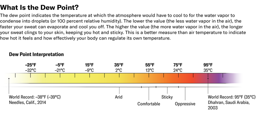
This heat wave is not as intense as the one that sent temperatures soaring well into the triple digits in the Southwest in March, but it’s still bringing temperatures into the 90s Fahrenheit from the mid-Atlantic to the Northeast—well ahead of average. Humidity is also rising, with dew points in the 60s F—that’s not as sweltering as they can be in the dog days of summer, but it’s the highest they have been so far this year, says Marc Chenard, a meteorologist at the National Weather Service’s (NWS’s) Weather Prediction Center.
Zane Wolf; Source: National Weather Service (data)
.
Though this week’s temperatures won’t challenge any all-time record highs, they still pose a health risk because people are less acclimated to heat this early in the year. The NWS’s HeatRisk map tool shows “major” heat risk—the second highest category—from Washington, D.C., up to Boston. Relatively high overnight temperatures are a particular concern because they mean people’s body doesn’t have a chance to cool down and recover.
Climate change is driving this event, too. Overall, summer heat waves are becoming more intense, longer-lasting, and more frequent. The high-heat season is also bleeding into spring and fall. For this particular heat wave, a tool from the nonprofit research group Climate Central shows that this heat event is two to five times more likely because of climate change.
This heat wave will be short-lived for northern areas because a “back-door cold front” will roll through later on Wednesday, Chenard says. First, a more traditional cold front, with winds from the northwest, will move into the area, and then winds will switch to become northeasterly. That shift will reinforce the coolness and keep the heat from reasserting itself over the mid-Atlantic and Northeast. The Southeast, though, will continue to feel sultry temperatures amid a widespread drought that is raising wildfire risks.
.
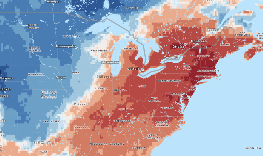
Temperatures were more than 10 degrees Fahrenheit above normal (darkest red shades) on May 19. Climate Central
Film and Writing Festival for Comedy. Showcasing best of comedy short films at the FEEDBACK Film Festival. Plus, showcasing best of comedy novels, short stories, poems, screenplays (TV, short, feature) at the festival performed by professional actors.


May 24, 2026 @ 02:23:20
Nice information.
LikeLike
May 24, 2026 @ 02:40:16
Thank you sir! Some people will say the end the near cause you can’t tell winter from summer!
LikeLiked by 1 person