
Click the link below the picture
.
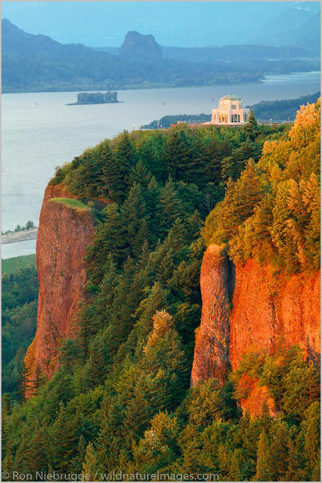
The Columbia River Gorge is a canyon of the Columbia River in the Pacific Northwest of the United States. Up to 4,000 feet (1,200 m) deep, the canyon stretches for over eighty miles (130 km) as the river winds westward through the Cascade Range, forming the boundary between the state of Washington to the north and Oregon to the south. Extending roughly from the confluence of the Columbia with the Deschutes River (and the towns of Roosevelt, Washington, and Arlington, Oregon) in the east down to the eastern reaches of the Portland metropolitan area, the water gap furnishes the only navigable route through the Cascades and the only water connection between the Columbia Plateau and the Pacific Ocean. It is thus the route of Interstate 84, U.S. Route 30, Washington State Route 14, and railroad tracks on both sides.
A popular recreational destination, the gorge holds federally protected status as the Columbia Gorge National Scenic Area and is managed by the Columbia River Gorge Commission and the U.S. Forest Service.
The Columbia River, Klamath River in northern California, Pit River in northern California, and Fraser River in southern British Columbia are the only four rivers connecting the watersheds on the east side of the Cascade Range to the Pacific Ocean. Each river has created a gorge through the Cascades. The Columbia River Gorge marks the state line between Oregon and Washington, and its wide range of elevation and precipitation makes it an extremely diverse and dynamic place. Ranging from 4,000 feet (1,200 m) to sea level, and transitioning from 100 inches (2,500 mm) of precipitation to only 10 inches (250 mm) in 80 miles (130 km), the gorge creates a diverse collection of ecosystems, from the temperate rain forest on the western end—with an average annual precipitation of 75 to 100 inches (1,900 to 2,500 mm)—to the eastern grasslands with average annual precipitation between 10 and 15 inches (250 and 380 mm), to a transitional dry woodland between Hood River and The Dalles.[citation needed] Isolated micro-habitats have allowed for many species of endemic plants and animals to prosper, including at least 13 endemic wildflowers.
The gorge transitions between temperate rainforest to dry grasslands in only 80 miles (130 km), hosting a dramatic change in scenery while driving along Interstate 84. In the western, temperate rainforest areas, forests are marked by bigleaf maples, Douglas fir, and western hemlock, all covered in epiphytes. In the transition zone (between Hood River and The Dalles), vegetation turns to Oregon white oak, ponderosa pine, and cottonwood. At the eastern end, the forests make way for expansive grasslands, with occasional pockets of lodgepole and ponderosa pine. Wikipedia
.
 An image from Columbia River Gorge
.
.
Click the link below for images:
.
__________________________________________

Leave a comment