August 31, 2021
Mohenjo
Business, Enthralling, Human Interest, Photographs
amazon, business, Business News, current-events, Future, Hotels, human-rights, medicine, mental-health, research, Science, Science News, technology, Technology News, travel, vacation

Click the link below the picture
.
The hike around Robberg Peninsula is rated as one of the top things to do in Plettenberg Bay, South Africa. It is a 9 km hike around a peninsula jutting out into the Indian Ocean.
On this hike, we climbed up and down the rocky coastline, hiked past a colony of seals, and wandered on a second, smaller peninsula made of sand. The best part of the hike was the ever-changing scenery. Almost every fifteen minutes our views and the terrain we hiked on changed, making this one of the most interesting hikes we have done. Throw in an almost secluded beach and whale watching and you have a fabulous hike. Google
.
 An image from Robberg Peninsula South Africa
.
.
Click the link below for images:
.
__________________________________________
August 30, 2021
Mohenjo
Business, Enthralling, Human Interest, Photographs
amazon, business, Business News, current-events, Future, Hotels, human-rights, medicine, mental-health, research, Science, Science News, technology, Technology News, travel, vacation
Click the link below the picture
.
Yalova is a city located in northwestern Turkey, near the eastern coast of the Sea of Marmara. Yalova has a city population of 100,863, while the population of Yalova Province is 118,998 as of 2011. Currently, there is a controversy around the municipal election results in Yalova especially after the Supreme Election Board invalidated the 2014 Municipal Election results on April 24, 2014, after a few recounts that changed results.
In general, it is assumed that the name Yalova comes from Yalıova. Yalı means ‘house at the coast’ and ova means ‘plain’ in Turkish.
The first settlement in the region dates back to the Prehistoric Period, in around 3000 BC. The Hittites ruled the region in the 21st century BC, followed by the Phrygians in the 13th century BC, and thereafter by the Greeks in the archaic, classical, and Hellenistic eras. The region was conquered by the Romans in 74 BC. After the fall of the Roman Empire, the city was part of the Byzantine Empire.
In Antiquity and for most of the Middle Ages, the town was known as Pylae or Pylai (Greek: Πύλαι), in Bithynia, which is Greek for “gates”, as it was at the start of one of the main routes leading into Asia for whoever crossed the Sea of Marmara from Europe. Wikipedia
.
 An image from Yalova, Yalova Merkez/Yalova, Turkey
.
.
Click the link below for images:
.
__________________________________________
August 29, 2021
Mohenjo
Business, Enthralling, Human Interest, Photographs
amazon, business, Business News, current-events, Future, Hotels, human-rights, medicine, mental-health, research, Science, Science News, technology, Technology News, travel, vacation
Click the link below the picture
.
Acer palmatum, commonly known as Japanese maple, palmate maple, or smooth Japanese maple, is a species of woody plant native to Japan, Korea, China, eastern Mongolia, and southeast Russia. Many different cultivars of this maple have been selected and they are grown worldwide for their large variety of attractive forms, leaf shapes, and spectacular colors.
Acer palmatum is a deciduous shrub or small tree reaching heights of 6 to 10 m (20 to 33 ft), rarely 16 meters (52 ft), reaching a mature width of 4.5 to 10 meters (15 to 33 ft), often growing as an understory plant in shady woodlands. It may have multiple trunks joining close to the ground. In habit, its canopy often takes on a dome-like form, especially when mature. The leaves are 4–12 cm (1+1⁄2–4+3⁄4 in) long and wide, palmately lobed with five, seven, or nine acutely pointed lobes. The flowers are produced in small cymes, the individual flowers with five red or purple sepals and five whitish petals. The fruit is a pair of winged samaras, each samara 2–3 cm (3⁄4–1+1⁄4 in) long with a 6–8 mm (1⁄4–5⁄16 in) seed. The seeds of Acer palmatum and similar species require stratification in order to germinate.
Even in nature, Acer palmatum displays considerable genetic variation, with seedlings from the same parent tree typically showing differences in such traits as leaf size, shape, and color. The overall form of the tree can vary from upright to weeping. Wikipedia
.
 An image of a Dwarf Japanese Maple Tree
.
.
Click the link below for images:
.
__________________________________________
August 28, 2021
Mohenjo
Business, Enthralling, Human Interest, Photographs
amazon, business, Business News, current-events, Future, Hotels, human-rights, medicine, mental-health, research, Science, Science News, technology, Technology News, travel, vacation
Click the link below the picture
.
Ystad is a town and the seat of Ystad Municipality, in Scania County, Sweden. Ystad had 18,350 inhabitants in 2010. The settlement dates from the 11th century and has become a busy ferry port, local administrative center, and tourist attraction. The detective series Wallander, created by Henning Mankell, is set primarily in Ystad.
In 1285, the town’s name was written Ystath. Its original meaning is not fully understood, but the y probably is related to an old word for the yew tree, while stad means town or place.
After the time of Absalon, Bishop of Roskilde, and Archbishop of Lund, peace was brought to the area in the 11th century, fishing families settled at the mouth of the river Vassa as herring fishing became the main source of trade. Ystad was not mentioned in documents until 1244, in a record of King Eric’s visit to the town with his brother, Abel. A Franciscan monastery, Gråbrödraklostret, was founded in 1267, and Ystad joined the Hanseatic League in the 14th century.
The charter of 1599 gave the town the right to export oxen. Ystad, together with all of Scania, was transferred from Denmark to Sweden following the Treaty of Roskilde in 1658.
By 1866 Ystad had a railway connection and it was established as a garrison town in the 1890s. After World War II, ferry services to Poland and to the Danish island of Bornholm were opened. Wikipedia
.
 An image from Ystad, Sweden
.
.
Click the link below for images:
.
__________________________________________
August 27, 2021
Mohenjo
Business, Enthralling, Human Interest, Photographs
amazon, business, Business News, current-events, Future, Hotels, human-rights, medicine, mental-health, research, Science, Science News, technology, Technology News, travel, vacation
Click the link below the picture
.
If you drive south on Costa Rica’s Caribbean coastal road until it ends you will reach Playa Manzanillo, a small fishing town inside the Gandoca-Manzanillo Wildlife Refuge. There is something magical about reaching the end of the road, and this particular trip will not disappoint. Once there, you will have a stunning beach to sunbathe and swim, great snorkeling and beautiful hikes, and to make it just perfect…add a great Afro-Caribbean ambiance.
.
 An image from Manzanillo Limon
.
.
Click the link below for images:
.
__________________________________________
August 26, 2021
Mohenjo
Business, Enthralling, Human Interest, Photographs
amazon, business, Business News, current-events, Future, Hotels, human-rights, medicine, mental-health, research, Science, Science News, technology, Technology News, travel, vacation

Click the link below the picture
.
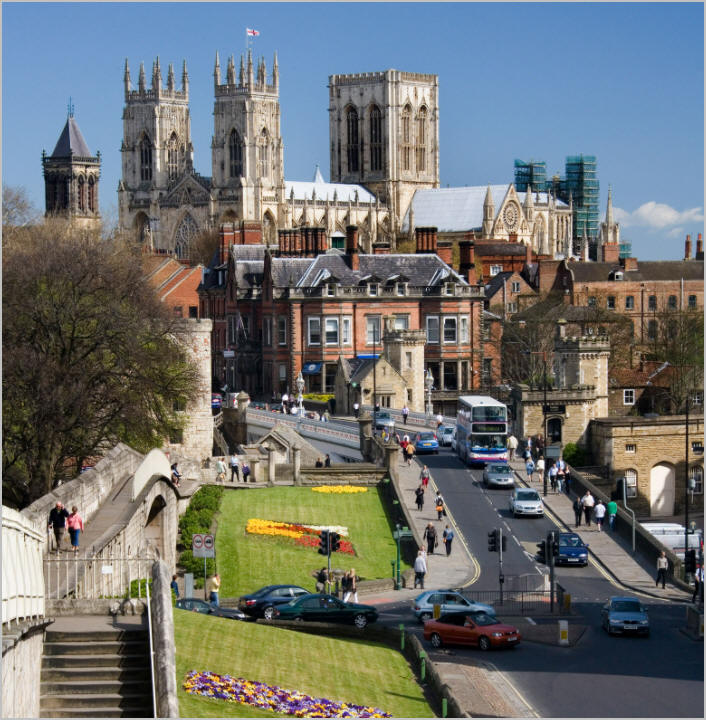
York is a cathedral city and unitary authority area, at the confluence of the rivers Ouse and Foss, in England. The city has long-standing buildings and structures, such as a minster, castle, and ancient city walls.
It is the head city of historic Yorkshire and was a county corporate, outside of the county’s council and the ridings. City of York Council is a unitary authority responsible for providing all local services and facilities throughout the city and rural areas around the outside of the old city boundaries. The city is in ceremonial North Yorkshire and a non-constituent member of the Leeds city region.
The city was founded by the Romans as Eboracum in 71 AD. It became the capital of the Roman province of Britannia Inferior, and later of the kingdoms of Deira, Northumbria, and Jórvík. In the Middle Ages, York grew as a major wool trading center and became the capital of the northern ecclesiastical province of the Church of England, a role it has retained. In the 19th century, York became a major hub of the railway network and a confectionery manufacturing center, a status it maintained well into the 20th century. During the Second World War, York was bombed as part of the Baedeker Blitz. Although less affected by bombing than other northern cities, several historic buildings were gutted and restoration efforts continued into the 1960s.
The city had a population of 153,717 in the 2011 census and is in the Yorkshire and the Humber region. The district borough, governed from the city, had a mid-2019 est. population of 210,618, the 87th most populous district in England. Wikipedia
.
 An image from York, UK
.
.
Click the link below for images:
.
__________________________________________
August 25, 2021
Mohenjo
Business, Enthralling, Human Interest, Photographs
amazon, business, Business News, current-events, Future, Hotels, human-rights, medicine, mental-health, research, Science, Science News, technology, Technology News, travel, vacation
Click the link below the picture
.
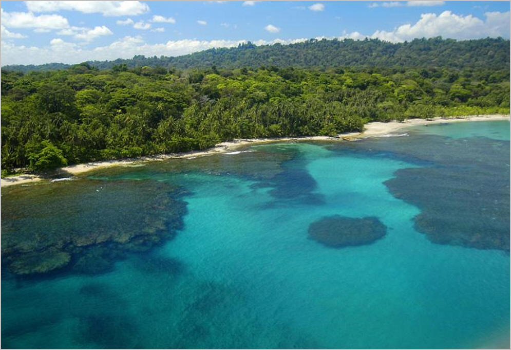
Located in Costa Rica’s southeastern Talmanca region is the large Gandoca-Manzanillo Refuge, a collection of rainforest and wetland habitat complete with a coral reef. At 23,348 total acres (9,450 ha), this vast refuge begins south of Punta Uva-3 miles south of Puerto Viejo-until it runs into the Sixaola River at the Panamanian border. Besides Cahuita, this park is the only other place in the country with a coral reef.
.
 An image from Gandoca-Manzanillo Wildlife Refuge
.
.
Click the link below for images:
.
__________________________________________
August 24, 2021
Mohenjo
Business, Enthralling, Human Interest, Photographs
amazon, business, Business News, current-events, Future, Hotels, human-rights, medicine, mental-health, research, Science, Science News, technology, Technology News, travel, vacation
Click the link below the picture
.
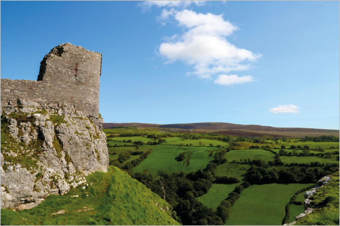
The Brecon Beacons National Park is one of three national parks in Wales and is centered on the Brecon Beacons range of hills in southern Wales. It includes the Black Mountain in the west, Fforest Fawr (Great Forest) and the Brecon Beacons in the center, and the Black Mountains in the east.
The Brecon Beacons National Park was established in 1957, the third of the three Welsh parks after Snowdonia in 1951, and the Pembrokeshire Coast in 1952. It stretches from Llandeilo in the west to Hay-on-Wye in the northeast and Pontypool in the southeast, covering 519 square miles (1,340 km2) and encompassing four main regions – the Black Mountain in the west, reaching 802 meters (2631 feet) at Fan Brycheiniog, Fforest Fawr and the Brecon Beacons in the center, including the highest summit in the park and in South Wales at Pen y Fan 886 meters (2,907 feet) and the confusingly named Black Mountains in the east, where the highest point is Waun Fach 811 meters (2,661 feet). The western half gained European and global status in 2005 as Fforest Fawr Geopark. This includes the Black Mountain, the historic extent of Fforest Fawr, and much of the Brecon Beacons and surrounding lowlands.
The Black Mountains in the east are clearly separated from the central Beacons by the Usk valley between Brecon and Abergavenny. The other three regions form a continuous massif of high ground above 300 meters (1000′), and the divisions are less clear; the A470 road forms the approximate boundary between the central Beacons and Fforest Fawr, while a minor road from Sennybridge to Ystradgynlais divides Fforest Fawr from the Black Mountain range to the west. Wikipedia
.
 An image from Beacons, Wales
.
.
Click the link below for images:
.
__________________________________________
August 23, 2021
Mohenjo
Business, Enthralling, Human Interest, Photographs
amazon, business, Business News, current-events, Future, Hotels, human-rights, medicine, mental-health, research, Science, Science News, technology, Technology News, travel, vacation
Click the link below the picture
.
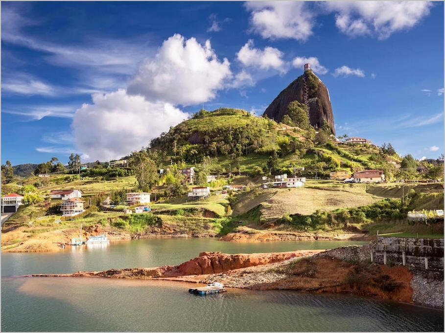
Colombia, officially the Republic of Colombia, is a country in South America. It is bounded on the north by the Caribbean Sea, the northwest by Panama, the south by Ecuador and Peru, the east by Venezuela, the southeast by Brazil, and the west by the Pacific Ocean. Colombia is composed of 32 departments and the Capital District of Bogotá, the country’s largest city. It covers an area of 1,141,748 square kilometers (440,831 sq mi), with a population of 50 million. Colombia’s rich cultural heritage reflects influences by various Amerindian civilizations, European settlement, African slaves, and immigration from Europe and the Middle East. Spanish is the nation’s official language, besides which over 70 languages are spoken.
Colombia has been inhabited by various indigenous peoples since at least 12,000 BCE, including the Muisca, Quimbaya, and the Tairona. The Spanish landed first in La Guajira in 1499 and by the mid-16th century colonized parts of the region, establishing the New Kingdom of Granada, with Santafé de Bogotá as its capital. Independence from the Spanish Empire was achieved in 1810, with what is now Colombia emerging as the United Provinces of New Granada. The new nation experimented with federalism as the Granadine Confederation (1858), and then the United States of Colombia (1863), before the Republic of Colombia was finally declared in 1886. Panama seceded in 1903, leading to Colombia’s present borders. Beginning in the 1960s, the country has suffered from an asymmetric low-intensity armed conflict and political violence, both of which escalated in the 1990s. Since 2005, there has been significant improvement in security, stability, and rule of law, as well as unprecedented economic growth and development.
.
 An image from Colombia Scenery
.
.
Click the link below for images:
.
__________________________________________
August 21, 2021
Mohenjo
Business, Enthralling, Human Interest, Photographs
amazon, business, Business News, current-events, Future, Hotels, human-rights, medicine, mental-health, research, Science, Science News, technology, Technology News, travel, vacation
Click the link below the picture
.
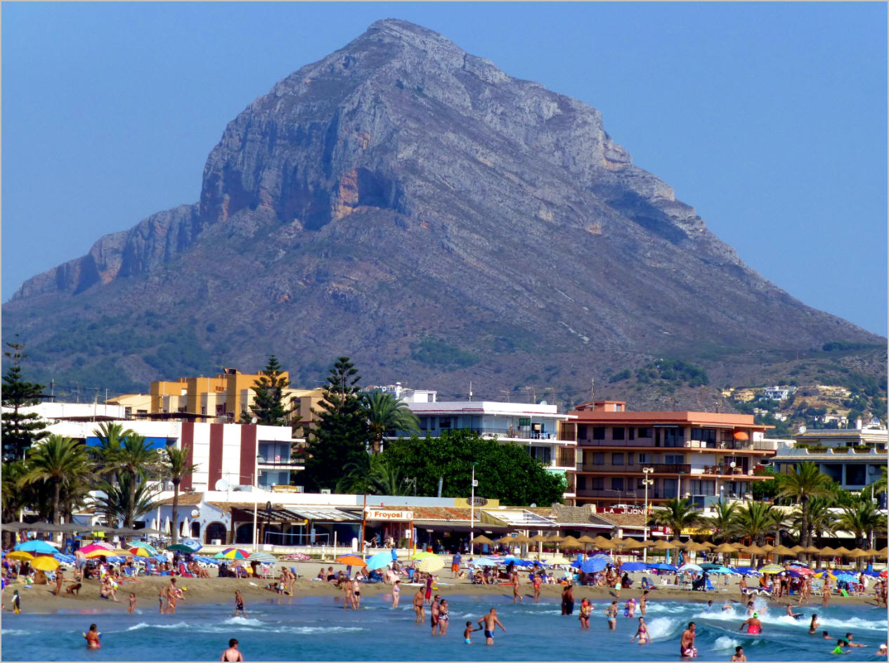
Xàbia is a coastal town in the comarca of Marina Alta, in the province of Alicante, Valencia, Spain, by the Mediterranean Sea. Situated on the side of the Montgó Massif, behind a wide bay and sheltered between two rocky headlands, the town has become a very popular small seaside resort and market town. Half of its resident population and over two-thirds of its annual visitors are foreigners.
The area was first inhabited in prehistoric times, 30,000 years ago by cave dwellers on Montgó. Subsequent residents have included Stone and Bronze-age peoples, Romans, Greeks, Phoenicians, Visigoths, Germanic, Carthaginians, and Moors. Roman fishing boats used the port, and there is evidence that dates the Roman occupation of Xàbia to the 2nd century BC, it makes Xàbia the oldest known Roman site on the coast with a commercial port for fish and minerals.
In the 6th century AD, Christian Visigoth monks came to Xàbia and founded the monastery of Sant Martí, which likely gave its name to the cape in the area named Cap San Martí. Hermenegild, son of the Visigoth king Leovigild of Toledo, sought refuge in the Monastery after angering his father by marrying a Christian girl. When his father’s troops arrived to arrest him all but one monk fled to Portichol; Hermenegild and the old monk were killed. Several people with Visigoth names still live in the area. Wikipedia
.
 An image from Xabia, Spain
.
.
Click the link below for images:
.
__________________________________________
Older Entries
Newer Entries
