January 15, 2022
Mohenjo
Business, Enthralling, Human Interest, Photographs
amazon, business, Business News, current-events, Future, Hotels, human-rights, medicine, mental-health, research, Science, Science News, technology, Technology News, travel, vacation

Click the link below the picture
.
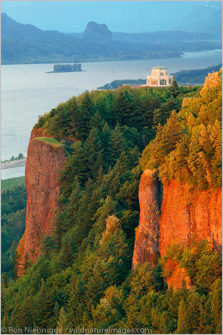
The Columbia River Gorge is a canyon of the Columbia River in the Pacific Northwest of the United States. Up to 4,000 feet (1,200 m) deep, the canyon stretches for over eighty miles (130 km) as the river winds westward through the Cascade Range, forming the boundary between the state of Washington to the north and Oregon to the south. Extending roughly from the confluence of the Columbia with the Deschutes River (and the towns of Roosevelt, Washington, and Arlington, Oregon) in the east down to the eastern reaches of the Portland metropolitan area, the water gap furnishes the only navigable route through the Cascades and the only water connection between the Columbia Plateau and the Pacific Ocean. It is thus the route of Interstate 84, U.S. Route 30, Washington State Route 14, and railroad tracks on both sides.
A popular recreational destination, the gorge holds federally protected status as the Columbia Gorge National Scenic Area and is managed by the Columbia River Gorge Commission and the U.S. Forest Service.
The Columbia River, Klamath River in northern California, Pit River in northern California, and Fraser River in southern British Columbia are the only four rivers connecting the watersheds on the east side of the Cascade Range to the Pacific Ocean. Each river has created a gorge through the Cascades. The Columbia River Gorge marks the state line between Oregon and Washington, and its wide range of elevation and precipitation makes it an extremely diverse and dynamic place. Ranging from 4,000 feet (1,200 m) to sea level, and transitioning from 100 inches (2,500 mm) of precipitation to only 10 inches (250 mm) in 80 miles (130 km), the gorge creates a diverse collection of ecosystems, from the temperate rain forest on the western end—with an average annual precipitation of 75 to 100 inches (1,900 to 2,500 mm)—to the eastern grasslands with average annual precipitation between 10 and 15 inches (250 and 380 mm), to a transitional dry woodland between Hood River and The Dalles.[citation needed] Isolated micro-habitats have allowed for many species of endemic plants and animals to prosper, including at least 13 endemic wildflowers.
The gorge transitions between temperate rainforest to dry grasslands in only 80 miles (130 km), hosting a dramatic change in scenery while driving along Interstate 84. In the western, temperate rainforest areas, forests are marked by bigleaf maples, Douglas fir, and western hemlock, all covered in epiphytes. In the transition zone (between Hood River and The Dalles), vegetation turns to Oregon white oak, ponderosa pine, and cottonwood. At the eastern end, the forests make way for expansive grasslands, with occasional pockets of lodgepole and ponderosa pine. Wikipedia
.
 An image from Columbia River Gorge
.
.
Click the link below for images:
.
__________________________________________
January 14, 2022
Mohenjo
Business, Enthralling, Human Interest, Photographs
amazon, business, Business News, current-events, Future, Hotels, human-rights, medicine, mental-health, research, Science, Science News, technology, Technology News, travel, vacation
Click the link below the picture
.
Guatapé is a town and municipality in the Department of Antioquia, Colombia. It is a part of the subregion of Eastern Antioquia and is located 79 kilometers (49 mi) from Medellín, the capital of the department. Guatapé is bordered on the north by Alejandría, San Rafael to the east, and Granada and El Peñol to the south. This town is the gathering place for Las Vegas, referring to the small farms of the area.
The town is a major tourist attraction, especially for travelers from Medellín. El Peñón de Guatapé, a large rock that visitors can climb, and the famous zócalos (murals) that adorn several buildings attract many tourists.
Before Iberian conquistadors reached the area in the 16th century, this territory was inhabited by indigenous groups, some controlled by a cacique named Guatape. In his honor, the town was named after him. The name “Guatapé”, comes from the Quechua language, related to “stones and water”. Another name that the town had in the past was “La Ceja de Guatapé”.
In 1714, the indigenous people under Guatapé of this region were grouped into a shelter known as “San Antonio de Remolinos Peñol”. Traces of their existence come from clay urns found in the town of Alto Verde, and several archaeological sites not yet studied in the villages of La Peña, La Piedra, El Roble, and El Rosario.
Guatapé was founded 4 October 1811, by the Spaniard Don Francisco Giraldo y Jimenez. It was declared a municipality in September 1867.
Guatapé has undergone changes throughout its history. It was predominately a farming town that relied on livestock, agriculture, and mining. Empresas Públicas de Medellín built a large hydroelectric complex here in the 1970s. This megaproject produced large impacts on social, economic, political, environmental, and cultural development in the locality. With the construction of this dam, Guatapé became one of the most important electric production centers in the country. Wikipedia
.
 An image from Guatape, Colombia
.
.
Click the link below for images:
.
__________________________________________
January 13, 2022
Mohenjo
Business, Enthralling, Human Interest, Photographs
amazon, business, Business News, current-events, Future, Hotels, human-rights, medicine, mental-health, research, Science, Science News, technology, Technology News, travel, vacation
Click the link below the picture
.
The Valle Verzasca is a valley in the Locarno district of the Canton of Ticino, Switzerland. It comprises the municipalities of Mergoscia, Vogorno, Corippo, Lavertezzo, Brione, Gerra, Frasco, and Sonogno. As of 2004, the total population is 3,200. Mergoscia is at the geographical center of the Ticino, and none of the passes out of the valley cross cantonal or national borders. The valley is formed by the Verzasca River and is situated between the Leventina and the Maggia and culminates at Pizzo Barone.
Located between the Leventina and the Valle Maggia valleys, Valle Verzasca extends over a length of 25 kilometers (16 mi) in a north-south direction and is situated in the north of the Lago Maggiore. The valley floor is at about 500 meters (1,640 ft) to 900 meters (2,953 ft)above sea level. The surrounding mountain passes respectively have an average altitude of 2,400 meters (7,874 ft). The Valley is crossed by the Verzasca river which is dammed at the southernly outlet of the Valley, forming the Lago di Vogorno, before it flows in the Magadino plain in the vicinity of the Ticino River in the Lago Maggiore.
Due to the different altitudes, all climate zones are combined in the Valle Verzasca. Tenero-contra and Gordola include the insubric climate region thanks to the deep sea level, close to the Lago Maggiore, and protected by the mountains from the north winds. Vineyards and Mediterranean vegetation benefit from the mildest climate area of Switzerland, nebulae are rare, and rainfall of short duration. With increasing altitude, the hills and mountain climate goes over to regions dominated by the Alpine climate (over 2,000 meters (6,562 ft)).
The diversity benefits among other things, the cultivation of vines, and it flourish chestnut forests and palm trees thrive. Due to differences in soil type and amounts, almost all flora occurring in the Ticino and fauna of the various environmental zones are found in the Verzasca Valley.
The Romans introduced and comparable to the tropical wood species, Castanea sativa is in the southern part of the valley, below 1,000 meters (3,281 ft), the dominant species. It is no longer actively cultivated but favors the further diffusion, and studies suggest to take advantage of the valuable wood of chestnut as a valuable wood.
In the Valle Verzasca, the endemic Nera Verzasca goat has been preserved, which looks very much like the ancient Roman goat. This medieval durable goat has short hair because it’s not stuck in the snow. Wikipedia
.
 An image from Lavertezzo, Valle Verzasca, Verzasca Valley, Ticino, Switzerland, Europe
.
.
Click the link below for article:
.
__________________________________________
January 12, 2022
Mohenjo
Business, Enthralling, Human Interest, Photographs
amazon, business, Business News, current-events, Future, Hotels, human-rights, medicine, mental-health, research, Science, Science News, technology, Technology News, travel, vacation
Click the link below the picture
.
Aït Benhaddou is a historic ighrem or ksar (fortified village) along the former caravan route between the Sahara and Marrakech in present-day Morocco. It is considered a great example of Moroccan earthen clay architecture and has been a UNESCO World Heritage Site since 1987.
The site of the ksar has been fortified since the 11th century during the Almoravid period. None of the current buildings are believed to date from before the 17th century, but they were likely built with the same construction methods and designs as had been used for centuries before. The site’s strategic importance was due to its location in the Ounila Valley along one of the main trans-Saharan trade routes. The Tizi n’Tichka pass, which was reached via this route, was one of the few routes across the Atlas Mountains, crossing between Marrakech and the Dra’a Valley on the edge of the Sahara. Other kasbahs and ksour were located all along this route, such as the nearby Tamdaght to the north.
Today, the ksar itself is only sparsely inhabited by several families. The depopulation over time is a result of the valley’s loss of strategic importance in the 20th century. Most local inhabitants now live in modern dwellings in the village on the other side of the river, and make a living off agriculture and especially off the tourist trade. In 2011 a new pedestrian bridge was completed linking the old ksar with the modern village, with the aim of making the ksar more accessible and to potentially encourage inhabitants to move back into its historic houses.
The ksar is located on the slopes of a hill next to the Ounila River (Asif Ounila). The village’s buildings are grouped together within a defensive wall that includes corner towers and a gate. They include dwellings of various sizes ranging from modest houses to tall structures with towers. Some of the buildings are decorated in their upper parts with geometric motifs. The village also has a number of public or community buildings such as a mosque, a caravanserai, a kasbah (castle-like fortification), and the Marabout of Sidi Ali or Amer. At the top of the hill, overlooking the ksar, are the remains of a large fortified granary (agadir). There is also a public square, a Muslim cemetery, and a Jewish cemetery. Outside the ksar’s walls was an area where grain was grown and threshed. Wikipedia
.
 An image of Ait Benhaddou
.
.
Click the link below for images:
.
__________________________________________
January 11, 2022
Mohenjo
Business, Enthralling, Human Interest, Photographs
amazon, business, Business News, current-events, Future, Hotels, human-rights, medicine, mental-health, research, Science, Science News, technology, Technology News, travel, vacation
Click the link below the picture
.
Royal Natal National Park is an 80.94-square-kilometer (31.25 sq mi) park in KwaZulu-Natal province, South Africa, and forms part of the uKhahlamba Drakensberg Park World Heritage Site. Notwithstanding the name, it is actually not a South African National Park managed by the SANParks, but rather a Provincial Park managed by Ezemvelo KZN Wildlife. This park is now included in the Maloti-Drakensberg Transfrontier Conservation Area Peace Park.
The Drakensberg Mountains were once the hunting ground of the San people (bushmen). Though the San no longer live in the area, they recorded their exploits in the form of remarkable rock paintings.
The main features of the park are the Drakensberg Amphitheatre, a rock wall 5 kilometers (3.1 mi) long by up to 1,200 meters (3,900 ft) high, Mont-Aux-Sources peak where the Orange and Tugela rivers have their source, and the 948-meter (3,110 ft) Tugela Falls, the world’s second-highest waterfall. A distinctive rock feature and popular hiking destination in the park is the so-called “Policeman’s Helmet”. Wikipedia
.
 An image from Royal Natal National Park
.
.
Click the link below for images:
.
__________________________________________
January 10, 2022
Mohenjo
Business, Enthralling, Human Interest, Photographs
amazon, business, Business News, current-events, Future, Hotels, human-rights, medicine, mental-health, research, Science, Science News, technology, Technology News, travel, vacation
Click the link below the picture
.
The king penguin is the second largest species of penguin, smaller, but somewhat similar in appearance to the emperor penguin. There are two subspecies: A. p. patagonicus and A. p. halli; patagonicus is found in the South Atlantic and halli in the South Indian Ocean (at the Kerguelen Islands, Crozet Island, Prince Edward Islands, and Heard Island and McDonald Islands) and at Macquarie Island.
King penguins mainly eat lanternfish, squid, and krill. On foraging trips, king penguins repeatedly dive to over 100 meters (300 ft) and have been recorded at depths greater than 300 meters (1,000 ft). Predators of the king penguin include giant petrels, skuas, the snowy sheathbill, the leopard seal, and the orca.
King penguins breed on the Subantarctic islands at the northern reaches of Antarctica, South Georgia, and other temperate islands of the region.
The king penguin stands at 70 to 100 cm (28 to 39 in) tall and weighs from 9.3 to 18 kg (21 to 40 lb). Although female and male king penguins are monomorphic they can be separated by their calls. Males are also slightly larger than females. The mean body mass of adults from Marion Island was 12.4 kg (27 lb) for 70 males and 11.1 kg (24 lb) for 71 females. Another study from Marion Island found that the mean mass of 33 adults feeding chicks was 13.1 kg (29 lb). The king penguin is approximately 25% shorter and weighs around 1/3rd less than the emperor penguin.
At first glance, the king penguin appears very similar to the larger, closely related emperor penguin, with a broad cheek patch contrasting with surrounding dark feathers and yellow-orange plumage at the top of the chest. However, the cheek patch of the adult king penguin is a solid bright orange whereas that of the emperor penguin is yellow and white, and the upper chest tends to be more orange and less yellowish in the king species. Both have colorful markings along the side of their lower mandible, but these tend towards pink in emperor penguins and orange in king penguins. Emperor and king penguins typically do not inhabit the same areas in the wild, with the possible exception of vagrants at sea, but the two can readily be distinguished from one another by the king’s longer, straighter bill, larger flippers, and noticeably sleeker body. The juvenile king penguin with its long bill and heavy dark brown down are completely different in appearance from the mostly grey emperor chick with its distinctive black and white mask. Once molted of its brown juvenile plumage, the king chick resembles the adult but is somewhat less colorful.
king penguins often breed on the same large, circumpolar islands as at least half of all living penguins, but it is easily distinguished from other species by its much larger size and taller frame, distinctive colorful markings, and grizzled sooty-greyish rather than blackish back. Wikipedia
.
 An image of a King Penguin Colony South Georgia Island
.
.
Click the link below for images:
.
__________________________________________
January 7, 2022
Mohenjo
Business, Enthralling, Human Interest, Photographs
amazon, business, Business News, current-events, Future, Hotels, human-rights, medicine, mental-health, research, Science, Science News, technology, Technology News, travel, vacation
Click the link below the picture
.
The Paraná River is a river in south Central South America, running through Brazil, Paraguay, and Argentina for some 4,880 kilometers (3,030 mi). It is second in length only to the Amazon River among South American rivers. It merges with the Paraguay River and then farther downstream with the Uruguay River to form the Río de la Plata and empties into the Atlantic Ocean.
The first European to go up the Paraná River was the Venetian explorer Sebastian Cabot, in 1526, while working for Spain.
In 2021 a drought has hit the river causing a 77-year low.
In eastern South America there is “an immense number of river names containing the element para- or parana-“, from Guarani language words meaning “river” or “sea”; attempts to derive a more precise meaning for the name of this, the largest of them, e.g. “kin of the sea”, have been discounted.
The course is formed at the confluence of the Paranaiba and Rio Grande rivers in southern Brazil. From the confluence, the river flows in a generally southwestern direction for about 619 km (385 mi) before encountering the city of Saltos del Guaira, Paraguay. This was once the location of the Guaíra Falls (Sete Quedas waterfalls, where the Paraná fell over a series of seven cascades. This natural feature was said to rival the world-famous Iguazu Falls to the south. The falls were flooded, however, by the construction of the Itaipu Dam, which began operating in 1984.
For approximately the next 200 km (120 mi) the Paraná flows southward and forms a natural boundary between Paraguay and Brazil until the confluence with the Iguazu River. Shortly upstream from this confluence, however, the river is dammed by the Itaipu Dam, the second-largest hydroelectric power plant in the world (following the Three Gorges Dam in the People’s Republic of China), and creating a massive, shallow reservoir behind it. Wikipedia
.
 An image of the Parana River
.
.
Click the link below for images:
.
__________________________________________
January 6, 2022
Mohenjo
Business, Enthralling, Human Interest, Photographs
amazon, business, Business News, current-events, Future, Hotels, human-rights, medicine, mental-health, research, Science, Science News, technology, Technology News, travel, vacation
Click the link below the picture
.
Fernando de Noronha (Brazilian Portuguese: [feʁˈnɐ̃du d(ʒ)i noˈɾoɲɐ]) is an archipelago in the Atlantic Ocean, part of the State of Pernambuco, Brazil, and located 354 km (220 mi) offshore from the Brazilian coast. It consists of 21 islands and islets, extending over an area of 26 km2 (10 sq mi). Only the eponymous main island is inhabited; it has an area of 18.4 km2 (7.1 sq mi) and a population estimated at 3,101 in 2020.
The islands are administratively unique in Brazil. They form a “state district” (Portuguese: distrito estadual) that is administered directly by the government of the state of Pernambuco (despite being closer to the state of Rio Grande do Norte). The state district’s jurisdiction also includes the very remote Saint Peter and Saint Paul Archipelago, located 625 km (388 mi) northeast of Fernando de Noronha. 70% of the islands’ area was established in 1988 as a national marine park.
In 2001, UNESCO designated it as a World Heritage Site because of its importance as a feeding ground for tuna, sharks, turtles, and marine mammals. Its time zone is UTC−02:00 all year round.
Fernando de Noronha’s occupation dates to the early 16th century. Due to its geographical position, the archipelago was one of the first lands sighted in the New World, being shown in a nautical chart in 1500 by the Spanish cartographer Juan de La Cosa, and in 1502 by the Portuguese Alberto Cantino, in the latter with the name “Quaresma”.
Based on the written record, Fernando de Noronha island was discovered on August 10, 1503, by a Portuguese expedition, organized and financed by a private commercial consortium headed by the Lisbon merchant Fernão de Loronha. The expedition was under the overall command of captain Gonçalo Coelho and carried the Italian adventurer Amerigo Vespucci aboard, who wrote an account of it. The flagship of the expedition hit a reef and foundered near the island, and the crew and contents had to be salvaged. On Coelho’s orders, Vespucci anchored at the island, and spent a week there, while the rest of the Coelho fleet went on south. In his letter to Soderini, Vespucci describes the uninhabited island and reports its name as the “island of St. Lawrence” (August 10 is the feast day of St. Lawrence; it was a custom of Portuguese explorations to name locations by the liturgical calendar). Wikipedia
.
 An image from Fernando de Noronha
.
.
Click the link below for images:
.
__________________________________________
January 5, 2022
Mohenjo
Business, Enthralling, Human Interest, Photographs
amazon, business, Business News, current-events, Future, Hotels, human-rights, medicine, mental-health, research, Science, Science News, technology, Technology News, travel, vacation
Click the link below the picture
.
Cape Le Grand National Park is a national park in Western Australia, 631 km (392 mi) south-east of Perth and 56 km (35 mi) east of Esperance. The park covers an area of 31,801 hectares (78,580 acres) The area is an ancient landscape which has been above sea level for well over 200 million years and remained unglaciated. As a result, the area is home to many primitive relict species. Established in 1966, the park is managed by the Department of Parks and Wildlife. The name Le Grand is from one of the officers on L’Espérance, one of the ships in the 1792 expedition of Bruni d’Entrecasteaux.
The largely granite shoreline and white sand beaches are picturesque features of the area. The park is used for fishing, off-roading, tourism, and hiking. Beaches within the Park include those at Lucky Bay, Rossiter Bay, Hellfire Bay, Le Grand Beach, and Thistle Cove. The islands and waters to the south of the park are known as the Recherche Archipelago Nature Reserve, another protected area of the Recherche Archipelago and nearby coastal regions. The Cape Arid National Park is located to the east. The southwest section of the Park is dominated by rock outcrops of gneiss and granite. These form a distinctive chain of peaks including Mount Le Grand (345 m), Frenchman Peak (262 m), and Mississippi Hill (180 m, named after the Mississippi, a French whaler). Further inland, the park comprises mostly heath-covered sandplain, interspersed with swamps and pools of fresh water.
The sandplains support dense stands of banksias (Banksia speciosa and Banksia pulchella).
Other flora that can be found around the park include Melaleucas, Grevilleas, sheoaks, Christmas trees, and grass trees. Wildflower blooms peak in the austral spring, lasting until October, and species such as blue china orchid Cyanicula gemmata, Diuris corymbosa, Hakea laurina, Thysanotus sparteus, and Thelymitra macrophylla are represented within the park.
Fauna that are commonly found within the park include bandicoots, pygmy honey possums, ring-tailed possums, quenda, and western grey kangaroos. Some of the relict species with gondwanan links that are found within the park include legless lizards, like the common scaly-foot Pygopus lepidopodus, and Delma fraseri, Delma australis, and Aprasia striolata. The ancient, although non-gondwanan, blind snake Ramphotyphlops australis is also found within the park. Endemic frogs found within the area include the |quacking frog Crinia georgiana, the banjo frog Limnodynastes dorsalis, and the humming frog Neobatrachus pelobatoides. Wikipedia
.
 An image from Cape Le Grand National Park
.
.
Click the link below for images:
.
__________________________________________
January 4, 2022
Mohenjo
Business, Enthralling, Human Interest, Photographs
amazon, business, Business News, current-events, Future, Hotels, human-rights, medicine, mental-health, research, Science, Science News, technology, Technology News, travel, vacation
Click the link below the picture
.
Chobe National Park is Botswana’s first national park, and also the most biologically diverse. Located in the north of the country, it is Botswana’s third-largest park, after Central Kalahari Game Reserve and Gemsbok National Park, and has one of the greatest concentrations of game in all of Africa.
This park is noted for having a population of lions which prey on elephants, mostly calves or juveniles, but also subadults.
The original inhabitants of this area were the San bushmen (also known as the Basarwa people in Botswana). They were nomadic hunter-gatherers who were constantly moving from place to place to find food sources, namely fruits, water, and wild animals. Nowadays one can find San paintings inside rocky hills of the park.
At the beginning of the 20th century, the region that would become Botswana was divided into different land tenure systems. At that time, a major part of the park’s area was classified as crown land. The idea of a national park to protect the varied wildlife found here as well as promote tourism first appeared in 1931. The following year, 24,000 km2 (9,300 sq mi) around Chobe district were officially declared non-hunting area; this area was expanded to 31,600 km2 (12,200 sq mi) two years later.
In 1943, heavy tsetse infestations occurred throughout the region, delaying the creation of the national park. By 1953, the project received governmental attention again: 21,000 km2 (8,100 sq mi) were suggested to become a game reserve. Chobe Game Reserve was officially created in 1960, though smaller than initially desired. In 1967, the reserve was declared a national park.
At that time there were several industrial settlements in the region, especially at Serondela, where the timber industry proliferated. These settlements were gradually moved out of the park, and it was not until 1975 that the whole protected area was exempt from human activity. Nowadays traces of the prior timber industry are still visible at Serondela. Minor expansions of the park took place in 1980 and 1987. Wikipedia
.
 An image from Chobe National Park
.
.
Click the link below for images:
.
__________________________________________
Older Entries
Newer Entries
