January 27, 2022
Mohenjo
Business, Enthralling, Human Interest, Photographs
amazon, business, Business News, current-events, Future, Hotels, human-rights, medicine, mental-health, research, Science, Science News, technology, Technology News, travel, vacation

Click the link below the picture
.
Bieszczady National Park is the third-largest national park in Poland, located in Subcarpathian Voivodeship in the extreme southeast corner of the country. In 2021, the national park became a UNESCO World Heritage Site (as an extension to the Ancient and Primeval Beech Forests of the Carpathians and Other Regions of Europe).
The park was created in 1973. At the time it covered only 59.55 square kilometers (22.99 sq mi), but over the years it was enlarged four times. The last enlargements took place in 1996 (when the park incorporated the former villages of Bukowiec, Beniowa, and Carynskie) and in 1999 (when the former villages of Dzwiniacz, Tarnawa, and Sokoliki were added).
It occupies 292.02 square kilometers (112.75 sq mi), covering the highest areas of the Polish part of the Bieszczady Mountains. In 1992 the park and its surrounding areas became part of the UNESCO East Carpathian Biosphere Reserve, which has a total area of 2,132.11 square kilometers (823.21 sq mi) and includes parts in Slovakia and (since 1998) Ukraine.
Forests cover about 80% of Bieszczady National Park. The woods are mainly natural; in some cases, it can be said that they have preserved their pristine character. The highest peak in the park, Tarnica, is 1,346 meters (4,416 ft) above sea level.
Animal life is abundant with several species of endangered animals thriving in the area, among them brown bears, grey wolf, European wildcat, wild boar, European beavers, European otter, and European lynx as well as deer (such as moose) and European bison (over 500 live in the area). The park contains interesting bird species, including eagles and owls, and is home to the largest Polish population of Aesculapian snakes.
The park is sparsely populated (less than 1 person per km2), which means that animals can roam freely. The region is very popular among tourists, but there are not many facilities. Around 70% of the park is regarded as strict preserve, which means that the use of trails is restricted. The park’s authorities promote walking trips.
.
 An image from Bieszczady National Park Poland
.
.
Click the link below for images:
.
__________________________________________
January 27, 2022
Mohenjo
Business, Food For Thought, Human Interest, Overlooked Past Article, Photographs, Science, Technical
amazon, business, Business News, current-events, Future, Hotels, human-rights, medicine, mental-health, research, Science, Science News, technology, Technology News, travel, vacation

Click the link below the picture
.
Due to its low light pollution, remote and idyllic landscapes, and a whole sub-population of people with a passion for astronomy, Hawaii may have been the Western Hemisphere’s sweetest spot for observing the “blood moon.”
The state, which is home to the famed Mauna Kea observatories on the Big Island of Hawaii and the Institute for Astronomy at the University of Hawaii on Oahu, is affectionately known as “Earth’s connecting point to the rest of the Universe.” Moreover, given Hawaii’s history with expert navigators, “knowledge of the night sky is an integral part of [Hawaii’s] culture and history,” according to the institute’s outreach coordinator and astronomer Dr. Roy Gal.
The time difference helps too. While most stargazers across North and South America had to set their alarms in order to catch the stellar sight, astronomy enthusiasts and several staffers from the institute and the observatories enjoyed the eclipse starting at about 8 p.m. HST on April 14.
“Mauna Kea is one of, if not, the most spiritually connected places I have ever set foot on,” photographer Andrew Richard Hara told HuffPost. “The ability to witness the entirety of the Milky Way with your bare eyes is something not only incredible but also humbling to acknowledge how interconnected we are with the Earth, atmosphere, and the space above.”
.
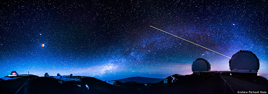 Photographer Andrew Richard Hara‘s composite of the eclipse alongside the W. M. Keck Observatory at the summit of Mauna Kea on the Big Island of Hawaii. At right, Keck’s Laser Guide Star Adaptive Optics system in action.
.
.
Click the link below for the article:
.
__________________________________________
January 26, 2022
Mohenjo
Business, Enthralling, Human Interest, Photographs
amazon, business, Business News, current-events, Future, Hotels, human-rights, medicine, mental-health, research, Science, Science News, technology, Technology News, travel, vacation
Click the link below the picture
.
Cambodia, officially the Kingdom of Cambodia, is a country located in the southern portion of the Indochinese Peninsula in Southeast Asia. It is 181,035 square kilometers (69,898 square miles) in area, bordered by Thailand to the northwest, Laos to the north, Vietnam to the east, the Gulf of Thailand to the southwest, and maritime borders with Thailand, Malaysia, and Indonesia. Phnom Penh is the nation’s capital and largest city.
The sovereign state of Cambodia has a population of over 15 million. Buddhism is enshrined in the constitution as the official state religion and is practiced by more than 97% of the population. Cambodia’s minority groups include Vietnamese, Chinese, Chams, and 30 hill tribes. The capital and largest city is Phnom Penh, the political, economic, and cultural center of Cambodia. The kingdom is an elective constitutional monarchy with a monarch, currently Norodom Sihamoni, chosen by the Royal Council of the Throne as head of state. The head of government is the Prime Minister, currently Hun Sen, the longest-serving non-royal leader in Southeast Asia, who has ruled since 1985.
The region now known as Cambodia has been inhabited since prehistoric times. In 802 AD, Jayavarman II declared himself king, uniting the warring Khmer princes of Chenla under the name “Kambuja”. This marked the beginning of the Khmer Empire, which flourished for over 600 years. The Indianised kingdom facilitated the spread of first Hinduism and then Buddhism to much of Southeast Asia and undertook many religious infrastructural projects throughout the region. Angkor Wat is the most famous of these structures and is designated as a World Heritage Site. In the fifteenth century, Cambodia experienced a decline of power, while its neighbors Vietnam and Thailand grew stronger. In 1863, Cambodia became a protectorate of France and later was incorporated into French Indochina. The country was under Japanese occupation during the Second World War before French control was restored.
Cambodia gained independence from France in 1953 and was led by King-turned politician Norodom Sihanouk. Despite Cambodia’s neutrality in the Vietnam War, the war extended into the country in 1965 with North Vietnam’s expansion of the Ho Chi Minh Trail and the establishment of the Sihanouk Trail. This led to the US bombing of Cambodia from 1969 until 1973. Following the 1970 coup which installed the right-wing pro-US Khmer Republic, the deposed King Sihanouk gave his support to his former enemies, the Khmer Rouge led by Pol Pot. With the support of the monarchy and North Vietnam, the Khmer Rouge emerged as a major power, taking Phnom Penh in 1975. The Khmer Rouge ruled the country and carried out the Cambodian genocide from 1975 until 1979 when they were ousted in the Cambodian–Vietnamese War. The Vietnamese-occupied People’s Republic of Kampuchea became the de facto government, with attempts to rebuild the country after the genocide mired by limited international recognition and ongoing conflict.
Following the 1991 Paris Peace Accords which formally ended the war with Vietnam, Cambodia was governed briefly by a United Nations mission (1992–93). The UN withdrew after holding elections in which around 90 percent of the registered voters cast ballots. The 1997 coup d’état consolidated power under Prime Minister Hun Sen and the Cambodian People’s Party, who remain in power. Wikipedia
.
 An image of a Cambodian Beach Resort
.
.
Click the link below for images:
.
__________________________________________
January 25, 2022
Mohenjo
Business, Enthralling, Human Interest, Photographs
amazon, business, Business News, current-events, Future, Hotels, human-rights, medicine, mental-health, research, Science, Science News, technology, Technology News, travel, vacation
Click the link below the picture
.
Giovanni Antonio Canal (18 October 1697 – 19 April 1768), commonly known as Canaletto, was an Italian painter from the Republic of Venice, considered an important member of the 18th-century Venetian school.
Painter of city views or vedute, of Venice, Rome, and London, he also painted imaginary views (referred to as capricci), although the demarcation in his works between the real and the imaginary is never quite clearcut. He was further an important printmaker using the etching technique. In the period from 1746 to 1756, he worked in England where he painted many views of London and other sites including Warwick Castle and Alnwick Castle. He was highly successful in England, thanks to the British merchant and connoisseur Joseph “Consul” Smith, whose large collection of Canaletto’s works was sold to King George III in 1762.
He was born in Venice as the son of the painter Bernardo Canal, hence his mononym Canaletto (“little Canal”), and Artemisia Barbieri. Canaletto served an apprenticeship with his father and his brother of a theatrical scene painter. During his time in Rome, he worked with his father producing the scenery for two operas by the composer Alessandro Scarlatti, Tito Sempronio Greco, and Turno Aricino which were performed at the Teatro Catranica during the carnival season of 1720.
Canaletto was inspired by the Roman vedutista Giovanni Paolo Pannini and started painting the daily life of the city and its people.
After returning from Rome in 1719, he began painting in his topographical style. His first known signed and dated work is Architectural Capriccio (1723, Milan, in a private collection). Studying with the older Luca Carlevarijs, a well-regarded painter of urban cityscapes, he rapidly became his master’s equal.
In 1725, the painter Alessandro Marchesini, who was also the buyer for the Lucchese art collector Stefano Conti, had inquired about buying two more ‘views of Venice’, when the agent urged him to consider instead the work of “Antonio Canale… it is like Carlevaris, but you can see the sun shining in it.” Wikipedia
.
 An image of a Canaletto Venice Painting
.
.
Click the link below for images:
.
__________________________________________
January 24, 2022
Mohenjo
Business, Enthralling, Human Interest, Photographs
amazon, business, Business News, current-events, Future, Hotels, human-rights, medicine, mental-health, research, Science, Science News, technology, Technology News, travel, vacation
Click the link below the picture
.
Bulgaria, officially the Republic of Bulgaria, is a country in Southeast Europe. It occupies the whole eastern part of the Balkans and is bordered by Romania to the north, Serbia and North Macedonia to the west, Greece and Turkey to the south, and the Black Sea to the east. Bulgaria covers a territory of 110,994 square kilometers (42,855 sq mi), and is the sixteenth largest country in Europe. Sofia is the nation’s capital and largest city; other major cities are Plovdiv, Varna, and Burgas.
One of the earliest societies in the lands of modern-day Bulgaria was the Neolithic Karanovo culture, which dates back to 6,500 BC. In the 6th to 3rd century BC, the region was a battleground for ancient Thracians, Persians, Celts, and Ancient Macedonians; stability came when the Roman Empire conquered the region in AD 45. After the Roman state splintered, tribal invasions in the region resumed. Around the 6th century, these territories were settled by the early Slavs. The Bulgars led by Asparuh of Bulgaria attacked from the lands of (Old Great) Bulgaria and permanently invaded the Balkans in the late 7th century. They established (Danubian) Bulgaria, victoriously recognized by treaty in AD 681 by the Eastern Roman Empire. It dominated most of the Balkans and significantly influenced Slavic cultures by developing the Cyrillic script. The First Bulgarian Empire lasted until the early 11th century when Byzantine emperor Basil II conquered and dismantled it. A successful Bulgarian revolt in 1185 established a Second Bulgarian Empire, which reached its apex under Ivan Asen II (1218–1241). After numerous exhausting wars and feudal strife, the empire disintegrated in 1396 and fell under Ottoman rule for nearly five centuries.
The Russo-Turkish War of 1877–78 resulted in the formation of the third and current Bulgarian state. Many ethnic Bulgarians were left outside the new nation’s borders, which stoked irredentist sentiments that led to several conflicts with its neighbors and alliances with Germany in both world wars. In 1946, Bulgaria came under the Soviet-led Eastern Bloc and became a socialist state. The ruling Communist Party gave up its monopoly on power after the revolutions of 1989 and allowed multiparty elections. Bulgaria then transitioned into a democracy and a market-based economy. Since adopting a democratic constitution in 1991, Bulgaria has been a unitary parliamentary republic composed of 28 provinces, with a high degree of political, administrative, and economic centralization.
Bulgaria is a developing country, with an upper-middle-income economy, ranking 56th in the Human Development Index. Its market economy is part of the European Single Market and is largely based on services, followed by industry—especially machine building and mining—and agriculture. Widespread corruption is a major socioeconomic issue; Bulgaria ranked as the most corrupt country in the European Union in 2018. The country also faces a demographic crisis, with its population shrinking annually since around 1990; it currently numbers roughly seven million, down from a peak of nearly nine million in 1988. Bulgaria is a member of the European Union, NATO, and the Council of Europe; it is also a founding member of the OSCE and has taken a seat on the United Nations Security Council three times. Wikipedia
.
 An image from Bulgaria
.
.
Click the link below for images:
.
__________________________________________
January 22, 2022
Mohenjo
Business, Enthralling, Human Interest, Photographs
amazon, business, Business News, current-events, Future, Hotels, human-rights, medicine, mental-health, research, Science, Science News, technology, Technology News, travel, vacation
Click the link below the picture
.
Logan is a city in Hocking County, Ohio. The population was 7,152 at the time of the 2010 census. It is the county seat of Hocking County. Logan is located in southeast Ohio, on the Hocking River 48 miles southeast of Columbus. The current mayor of Logan is Republican Greg Fraunfelter, who began a four-year term in January 2016 and was re-elected in 2019.
Logan is the county seat of Hocking County, Ohio. Residents named the town in honor of Chief Logan of the Mingo Indian tribe. He and his band lived in this area at the time of European-American settlement. Ohio Governor Thomas Worthington established the community in 1816.
Logan was incorporated as a city in 1839.
Logan was the first city in the state of Ohio to install a double roundabout. Located at the interchange of Ohio State Route 664 and U.S. Route 33, the roundabouts were officially opened to traffic on December 4, 2013.
According to the United States Census Bureau, the city has a total area of 4.93 square miles (12.77 km2), of which 4.79 square miles (12.41 km2) is land and 0.14 square miles (0.36 km2) is water.
As of the census of 2010, there were 7,152 people, 2,982 households, and 1,831 families residing in the city. The population density was 1,493.1 inhabitants per square mile (576.5/km2). There were 3,374 housing units at an average density of 704.4 per square mile (272.0/km2). The racial makeup of the city was 97.5% White, 0.8% African American, 0.3% Native American, 0.2% Asian, 0.3% from other races, and 0.9% from two or more races. Hispanic or Latino of any race were 0.8% of the population. Wikipedia
.
 An image from Logan, Ohio
.
.
Click the link below for images:
.
__________________________________________
January 20, 2022
Mohenjo
Business, Enthralling, Human Interest, Photographs
amazon, business, Business News, current-events, Future, Hotels, human-rights, medicine, mental-health, research, Science, Science News, technology, Technology News, travel, vacation
Click the link below the picture
.
A gazelle is any of many antelope species in the genus Gazella. This article also deals with the seven species included in two further genera, Eudorcas and Nanger, which were formerly considered subgenera of Gazella. A third former subgenus, Procapra, includes three living species of Asian gazelles.
Gazelles are known as swift animals. Some are able to run at bursts as high as 100 km/h (60 mph) or run at a sustained speed of 50 km/h (30 mph).[1] Gazelles are found mostly in the deserts, grasslands, and savannas of Africa; but they are also found in southwest and central Asia and the Indian subcontinent. They tend to live in herds, and eat less coarse, easily digestible plants and leaves.
Gazelles are relatively small antelopes, most standing 60–110 cm (2–3.5 ft) high at the shoulder, and are generally fawn-colored.
The gazelle genera are Gazella, Eudorcas, and Nanger. The taxonomy of these genera is confused, and the classification of species and subspecies has been an unsettled issue. Currently, the genus Gazella is widely considered to contain about 10 species. One species is extinct: the Queen of Sheba’s gazelle. Most surviving gazelle species are considered threatened to varying degrees. Closely related to the true gazelles are the Tibetan Goa and Mongolian gazelles (species of the genus Procapra), the blackbuck of Asia, and the African springbok.
One widely familiar gazelle is the African species Thomson’s gazelle (Eudorcas thomsoni), which is around 60 to 70 cm (24 to 28 in) in height at the shoulder and is coloured brown and white with a distinguishing black stripe. The males have long, often curved, horns. Like many other prey species, Tommies and springboks (as they are familiarly called) exhibit a distinctive behaviour of stotting (running and jumping high before fleeing) when they are threatened by predators, such as cheetahs, lions, African wild dogs, crocodiles, hyenas, and leopards.
Gazelle is derived from Arabic: غزال ġazāl, Maghrebi pronunciation ġazēl. To Europe it first came to Old Spanish and Old French, and then around 1600 the word entered the English language. The Arab people traditionally hunted the gazelle. Appreciated for its grace, it is a symbol most commonly associated in Arabic literature with female beauty. In many countries in Northwestern Sub-Saharan Africa, the gazelle is commonly referred to as “dangelo”, meaning “swift deer”. Wikipedia
.
 An image of Gazelles
.
.
Click the link below for images:
.
__________________________________________
January 19, 2022
Mohenjo
Business, Enthralling, Human Interest, Photographs
amazon, business, Business News, current-events, Future, Hotels, human-rights, medicine, mental-health, research, Science, Science News, technology, Technology News, travel, vacation
Click the link below the picture
.
Düsseldorf is the capital city of North Rhine-Westphalia, the most populous state of Germany. It is the second-largest city in the state and the seventh-largest city in Germany, with a population of 617,280.
Düsseldorf is located at the confluence of two rivers: the Rhine and the Düssel, a small tributary. The -dorf suffix means “village” in German (English cognate: thorp); its use is unusual for a settlement as large as Düsseldorf. Most of the city lies on the right bank of the Rhine (unlike Cologne, which is on the river’s left bank). Düsseldorf lies in the centre of both the Rhine-Ruhr and the Rhineland Metropolitan Region. It neighbours the Cologne Bonn Region to the south and the Ruhr to the north. It is the largest city in the German Low Franconian dialect area (closely related to Dutch).
Mercer’s 2012 Quality of Living survey ranked Düsseldorf the sixth most livable city in the world. Düsseldorf Airport is Germany’s third-busiest airport after those of Frankfurt and Munich, serving as the most important international airport for the inhabitants of the densely populated Ruhr, Germany’s largest urban area. Düsseldorf is an international business and financial centre, renowned for its fashion and trade fairs, and is headquarters to one Fortune Global 500 and two DAX companies. Messe Düsseldorf organises nearly one fifth of premier trade shows. As second largest city of the Rhineland, Düsseldorf holds Rhenish Carnival celebrations every year in February/March, the Düsseldorf carnival celebrations being the third most popular in Germany after those held in Cologne and Mainz.
There are 22 institutions of higher education in the city including the Heinrich-Heine-Universität Düsseldorf, the university of applied sciences (Hochschule Düsseldorf), the academy of arts (Kunstakademie Düsseldorf, whose members include Joseph Beuys, Emanuel Leutze, August Macke, Gerhard Richter, Sigmar Polke, and Andreas Gursky), and the university of music (Robert-Schumann-Musikhochschule Düsseldorf). The city is also known for its influence on electronic/experimental music (Kraftwerk) and its Japanese community. Düsseldorf is classified as a GaWC Beta+ world city.
When the Roman Empire was strengthening its position throughout Europe, a few Germanic tribes clung on in marshy territory off the eastern banks of the Rhine. In the 7th and 8th centuries, the odd farming or fishing settlement could be found at the point where the small river Düssel flows into the Rhine. It was from such settlements that the city of Düsseldorf grew. The first written mention of Düsseldorf (then called Dusseldorp in the local Low Rhenish dialect) dates back to 1135. Under Emperor Friedrich Barbarossa the small town of Kaiserswerth to the north of Düsseldorf became a well-fortified outpost, where soldiers kept a watchful eye on every movement on the Rhine. Kaiserswerth eventually became a suburb of Düsseldorf in 1929. In 1186, Düsseldorf came under the rule of the Counts of Berg. 14 August 1288 is one of the most important dates in the history of Düsseldorf. On this day the sovereign Count Adolf VIII of Berg granted the village on the banks of the Düssel town privileges. Before this, a bloody struggle for power had taken place between the Archbishop of Cologne and the count of Berg, culminating in the Battle of Worringen. Wikipedia
.
 An image from Dusseldorf, Germany
.
.
Click the link below for images:
.
__________________________________________
January 18, 2022
Mohenjo
Business, Enthralling, Human Interest, Photographs
amazon, business, Business News, current-events, Future, Hotels, human-rights, medicine, mental-health, research, Science, Science News, technology, Technology News, travel, vacation
Click the link below the picture
.
Fairy Falls is a 20-foot waterfall on the Oregon side of the Columbia River Gorge in the United States. As part of a tributary of Wahkeena Creek, Fairy Falls is located upstream from the much larger Wahkeena Falls. While small, this fan-shaped waterfall is a destination for photographers, mainly because of the scenic view. The creek cascades through a mossy rock slide lined with ferns, until rocky ledges of basalt break the water into various lacy streams. Wikipedia
.
 An image of Fairy Falls Columbia River Gorge
.
.
Click the link below for images:
.
__________________________________________
January 17, 2022
Mohenjo
Business, Enthralling, Human Interest, Photographs
amazon, business, Business News, current-events, Future, Hotels, human-rights, medicine, mental-health, research, Science, Science News, technology, Technology News, travel, vacation
Click the link below the picture
.
Maceió, formerly sometimes Anglicised as Macaio, is the capital and the largest city of the coastal state of Alagoas, Brazil. The name “Maceió” is an Indigenous term for a spring. Most maceiós flow to the sea, but some get trapped and form lakes (“lagoas”, in Portuguese).
There are numerous maceiós and lakes in this part of Brazil; because of this, the city was named Maceió, and the state, Alagoas. The new Zumbi dos Palmares International Airport connects Maceió with many Brazilian cities and also operates some international flights. The city is home to the Federal University of Alagoas.
The name “Maceió” has origin in the term tupi maçayó or maçaio-k, which means “what it covers the swamp”. The Aurélio Dictionary says that the term “maceió” means a temporary and cyclic lagoon that is located at the edge of the sea at the mouth of a watercourse small enough to be interrupted by a silicate bar until the high tide opens the way temporarily cyclically related to the season, river flow, lunar seasons, etc.
Nineteenth-century shipping reports, which reported on ships bringing cotton from Maceió, spelt it as Macaio.
The city began in an old sugar mill and plantation complex around the 19th century. Its development started with the arrival of ships taking wood from Jaraguá bay.
With the installation of the sugar mills, Maceió started to export sugar, then tobacco, coconut, leather, and some spices. Prosperity made it possible for the settlement to become a village on December 5, 1815. Thanks to its continued growth, Maceió became the capital of the Alagoas state on December 9, 1839.
Maceió is also a port city and due to its port development about 200 years ago it changed from a village into a city.
The city is located between the Mundaú Lagoon and the Atlantic Ocean, with a tropical climate with average temperature of 25 °C (77 °F). As of 2010, its metropolitan area had a total population of 1,156,287 inhabitants. Wikipedia
.
 An image from Maceió
.
.
Click the link below for images:
.
__________________________________________
Older Entries
Newer Entries
