April 8, 2022
Mohenjo
Business, Enthralling, Human Interest, Photographs
amazon, business, Business News, current-events, Future, Hotels, human-rights, medicine, mental-health, research, Science, Science News, technology, Technology News, travel, vacation

Click the link below the picture
.
The blue-footed booby is a marine bird native to subtropical and tropical regions of the eastern Pacific Ocean. It is one of six species of the genus Sula – known as boobies. It is easily recognizable by its distinctive bright blue feet, which is a sexually selected trait. Males display their feet in an elaborate mating ritual by lifting them up and down while strutting before the female. The female is slightly larger than the male and can measure up to 90 cm (35 in) long with a wingspan up to 1.5 m (5 ft).
The natural breeding habitats of the blue-footed booby are the tropical and subtropical islands of the Pacific Ocean. It can be found from the Gulf of California south along the western coasts of Central and South America to Peru. About half of all breeding pairs nest on the Galápagos Islands. Its diet mainly consists of fish, which it obtains by diving and sometimes swimming underwater in search of its prey. It sometimes hunts alone, but usually hunts in groups.
The blue-footed booby usually lays one to three eggs at a time. The species practices asynchronous hatching, in contrast to many other species whereby incubation begins when the last egg is laid and all chicks hatch together. This results in a growth inequality and size disparity between siblings, leading to facultative siblicide in times of food scarcity. This makes the blue-footed booby an important model for studying parent-offspring conflict and sibling rivalry.
The blue-footed booby was described by the French naturalist Alphonse Milne-Edwards in 1882 under the current binomial name Sula nebouxii. The specific epithet was chosen to honor the surgeon, naturalist, and explorer Adolphe-Simon Neboux (1806–1844). There are two recognized subspecies: Wikipedia
.
 An image of Blue-footed Boobys
.
.
Click the link below for images:
.
__________________________________________
April 7, 2022
Mohenjo
Business, Enthralling, Human Interest, Photographs
amazon, business, Business News, current-events, Future, Hotels, human-rights, medicine, mental-health, research, Science, Science News, technology, Technology News, travel, vacation
Click the link below the picture
.
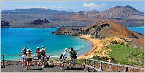
Bartolomé Island is a volcanic islet in the Galápagos Islands group, just off the east coast of Santiago Island. It is one of the “younger” islands in the Galápagos archipelago. This island, and Sulivan Bay on Santiago island, are named after naturalist and lifelong friend of Charles Darwin, Sir Bartholomew James Sulivan, who was a lieutenant aboard HMS Beagle.
Small Orange Lighthouse at the Summit of Bartolomé Island
With a total land area of just 1.2 square kilometers (0.5 square miles), this island offers some of the most beautiful landscapes in the archipelago. The island consists of an extinct volcano and a variety of red, orange, green, and glistening black volcanic formations.
Bartolomé has a volcanic cone that is easy to climb and provides great views of the other islands. Bartolomé is famous for its Pinnacle Rock, which is a distinctive characteristic of this island.
It has two visitor sites. At the first one, one may swim and snorkel around Pinnacle Rock; the underwater world there is really impressive. Snorkelers are in the water with the penguins, marine turtles, white-tipped reef sharks, and other tropical fish. The bay is also an excellent place to go swimming. The twin bays are separated by a narrow isthmus.
Galápagos penguins are frequently seen, and a small cave behind Pinnacle Rock houses a breeding colony. Seasonally, Bartolomé is the mating and nesting site for the green turtles. With herons, they make use of the gentler beaches. The Galápagos lava cacti colonize the new lava fields.
.
 An image from Bartolome Island
.
.
Click the link below for images:
.
__________________________________________
April 6, 2022
Mohenjo
Business, Enthralling, Human Interest, Photographs
amazon, business, Business News, current-events, Future, Hotels, human-rights, medicine, mental-health, research, Science, Science News, technology, Technology News, travel, vacation
Click the link below the picture
.
Singapore, officially the Republic of Singapore, is a sovereign island city-state in maritime Southeast Asia. It lies about one degree of latitude (137 kilometers or 85 miles) north of the equator, off the southern tip of the Malay Peninsula, bordering the Strait of Malacca to the west, the Riau Islands (Indonesia) to the south, and the South China Sea to the east. The country’s territory is composed of one main island, 63 satellite islands, and islets, and one outlying islet, the combined area of which has increased by 25% since the country’s independence as a result of extensive land reclamation projects. It has the third greatest population density in the world. With a multicultural population and recognizing the need to respect cultural identities, Singapore has four official languages; English, Malay, Mandarin, and Tamil. English is the lingua franca. Multiracialism is enshrined in the constitution and continues to shape national policies in education, housing, and politics.
Modern Singapore was founded in 1819 by Sir Stamford Raffles as a trading post of the British Empire. In 1867, the colonies in Southeast Asia were reorganized and Singapore came under the direct control of Britain as part of the Straits Settlements. During the Second World War, Singapore was occupied by Japan in 1942 and returned to British control as a separate crown colony following Japan’s surrender in 1945. Singapore gained self-governance in 1959 and in 1963 became part of the new federation of Malaysia, alongside Malaya, North Borneo, and Sarawak. Ideological differences led to Singapore being expelled from the federation two years later and it became an independent country.
After early years of turbulence and despite lacking natural resources and a hinterland, the nation rapidly developed to become one of the Four Asian Tigers based on external trade, becoming a highly developed country; it is ranked ninth on the UN Human Development Index and has the second-highest GDP per capita (PPP) in the world. Singapore is the only country in Asia with a AAA sovereign rating from all major rating agencies. It is a major financial and shipping hub, has consistently ranked the most expensive city to live in since 2013, and has been identified as a tax haven. Singapore is placed highly in key social indicators: education, healthcare, quality of life, personal safety, and housing, with a home-ownership rate of 91 percent. Singaporeans enjoy one of the longest life expectancies, fastest Internet connection speeds, lowest infant mortality rates, and lowest levels of corruption in the world.
Singapore is a unitary parliamentary republic with a Westminster system of unicameral parliamentary government. While elections are considered generally free, the government exercises significant control over politics and society, and the People’s Action Party has ruled continuously since independence. One of the five founding members of ASEAN, Singapore is also the headquarters of the Asia-Pacific Economic Cooperation (APEC) Secretariat, the Pacific Economic Cooperation Council (PECC) Secretariat, and many international conferences and events. Singapore is also a member of the United Nations, World Trade Organization, East Asia Summit, Non-Aligned Movement, and the Commonwealth of Nations. Wikipedia
.
 An image from Singapore
.
.
Click the link below for images:
.
__________________________________________
April 5, 2022
Mohenjo
Business, Enthralling, Human Interest, Photographs
amazon, business, Business News, current-events, Future, Hotels, human-rights, medicine, mental-health, research, Science, Science News, technology, Technology News, travel, vacation
Click the link below the picture
.
Vermilion Cliffs National Monument is located in northern Coconino County, Arizona, United States, immediately south of the Utah state line. This national monument, 293,689 acres (118,852 ha) in area, protects the Paria Plateau, Vermilion Cliffs, Coyote Buttes, and Paria Canyon. Elevations in the monument range from 3,100 feet to 6,500 feet above sea level (944 to 1,981 meters).
Established on November 9, 2000, by a presidential proclamation by President Bill Clinton, Vermilion Cliffs National Monument was carved from existing lands already under the management of the U.S. Government in extreme northern Coconino County, Arizona, immediately south of the border with the state of Utah. The monument is administered by the U.S. Bureau of Land Management, an agency within the U.S. Department of the Interior. The Vermilion Cliffs themselves run along the southern and eastern edges of the monument. Much of the monument’s land consists of the Paria Plateau, a flat area extending northward from the tops of the cliffs.
The Vermilion Cliffs are steep eroded escarpments consisting primarily of sandstone, siltstone, limestone, and shale which rise as much as 3,000 feet (910 m) above their bases. These sedimentary rocks have been deeply eroded for millions of years, exposing hundreds of layers of richly colored rock strata. Mesas, buttes, and large tablelands are interspersed with steep canyons, where some small streams provide enough moisture to support a sampling of wildlife.
More than twenty species of raptors, including bald eagles and golden eagles, peregrine falcons, and several hawk species, have been observed. The endangered California condor has been re-introduced into this region recently due to its remote location and lack of human habitation. Desert bighorn sheep, pronghorns, and mountain lions make up most of the large mammals found here, with about 30 more species of smaller mammals. Several examples of rare fish species, such as the flannel moth sucker and the speckled dace live in the streams of the monument. The Welsh’s milkweed Asclepias welshii, a threatened plant species that grows on sand dunes and helps stabilize them, is known to exist only in the monument and one other area in neighboring Utah. Wikipedia
.
 An image from White Pocket Vermilion Cliffs National Monument
.
.
Click the link below for images:
.
__________________________________________
April 4, 2022
Mohenjo
Business, Enthralling, Human Interest, Photographs
amazon, business, Business News, current-events, Future, Hotels, human-rights, medicine, mental-health, research, Science, Science News, technology, Technology News, travel, vacation
Click the link below the picture
.
Brazil officially the Federative Republic of Brazil is the largest country in both South America and Latin America. At 8.5 million square kilometers (3,300,000 sq mi) and with over 211 million people, Brazil is the world’s fifth-largest country by area and the sixth-most populous. Its capital is Brasília, and its most populous city is São Paulo. The federation is composed of the union of the 26 states and the Federal District. It is the largest country to have Portuguese as an official language and the only one in the Americas; it is also one of the most multicultural and ethnically diverse nations, due to over a century of mass immigration from around the world; as well as the most populous Roman Catholic-majority country.
Bounded by the Atlantic Ocean on the east, Brazil has a coastline of 7,491 kilometers (4,655 mi). It borders all other countries in South America except Ecuador and Chile and covers 47.3% of the continent’s land area. Its Amazon basin includes a vast tropical forest, home to diverse wildlife, a variety of ecological systems, and extensive natural resources spanning numerous protected habitats. This unique environmental heritage makes Brazil one of 17 megadiverse countries, and is the subject of significant global interest, as environmental degradation through processes like deforestation has direct impacts on global issues like climate change and biodiversity loss.
Brazil was inhabited by numerous tribal nations prior to the landing in 1500 of explorer Pedro Álvares Cabral, who claimed the area for the Portuguese Empire. Brazil remained a Portuguese colony until 1808 when the capital of the empire was transferred from Lisbon to Rio de Janeiro. In 1815, the colony was elevated to the rank of kingdom upon the formation of the United Kingdom of Portugal, Brazil, and the Algarves. Independence was achieved in 1822 with the creation of the Empire of Brazil, a unitary state governed under a constitutional monarchy and a parliamentary system. The ratification of the first constitution in 1824 led to the formation of a bicameral legislature, now called the National Congress. The country became a presidential republic in 1889 following a military coup d’état. An authoritarian military junta came to power in 1964 and ruled until 1985, after which civilian governance resumed. Brazil’s current constitution, formulated in 1988, defines it as a democratic federal republic. Due to its rich culture and history, the country ranks thirteenth in the world by number of UNESCO World Heritage Sites.
Brazil is a regional and middle power and is also classified as an emerging power. It is considered an advanced emerging economy, having the twelfth largest GDP in the world by nominal, and eighth by PPP measures. As an upper-middle-income economy by the World Bank and a newly industrialized country, Brazil has the largest share of global wealth in South America and it is one of the world’s major breadbaskets, being the largest producer of coffee for the last 150 years. However, the country maintains noticeable amounts of corruption, crime, and social inequality. Brazil is a founding member of the United Nations, the G20, BRICS, Mercosul, Organization of American States, Organization of Ibero-American States, and the Community of Portuguese Language Countries. Wikipedia
.
 An image from Brazilian Places
.
.
Click the link below for images:
.
__________________________________________
April 2, 2022
Mohenjo
Business, Enthralling, Human Interest, Photographs
amazon, business, Business News, current-events, Future, Hotels, human-rights, medicine, mental-health, research, Science, Science News, technology, Technology News, travel, vacation
Click the link below the picture
.
Lake Garda is the largest lake in Italy. It is a popular holiday location in northern Italy, about halfway between Brescia and Verona, and between Venice and Milan on the edge of the Dolomites. Glaciers formed this alpine region at the end of the last ice age. The lake and its shoreline are divided between the provinces of Verona (to the south-east), Brescia (south-west), and Trentino (north). The name Garda, which the lake has been referred to in documents dating to the 8th century, comes from the town of the same name. It is evolved from the Germanic word warda, meaning “place of guard”, “place of observation” or “place of safety”.
The northern part of the lake is narrower, surrounded by mountains, the majority of which belong to the Gruppo del Baldo. The shape is typical of a moraine valley, probably having been formed under the action of a Paleolithic glacier. Although traces of the glacier’s actions are evident today, in more recent years it has been hypothesized that the glacier occupied a previously existing depression, created by stream erosion 5 to 6 million years ago.
The lake has numerous small islands and five main ones, the largest being Isola del Garda, where, in 1220 St. Francis of Assisi founded a monastery. In its place now stands a 19th-century building in the Venetian Gothic style. Nearby to the south is Isola San Biagio, also known as the Isola dei Conigli (“Island of the Rabbits”). Both are offshore of San Felice del Benaco, on the lake’s western side. The three other main islands are Isola dell’Olivo, Isola di Sogno, and Isola di Trimelone, all farther north near the eastern side. The main tributary is the Sarca River, others include the Ponale River (fed by Lago di Ledro), the Varone/Magnone River (via the Cascate del Varone), and various streams from both mountainsides, while the only outlet is the Mincio River (79 meters (259 ft), at Peschiera). The subdivision is created by the presence of a fault submerged between Sirmione and Punta San Vigilio which is almost a natural barrier that hampers the homogenization between the water of the two zones.
If the water level of the Adige river is excessive, water is diverted to the lake through the Mori-Torbole tunnel. Wikipedia
.
 An image of Garda Lake, Italy
.
.
Click the link below for images:
.
__________________________________________
April 1, 2022
Mohenjo
Business, Enthralling, Human Interest, Photographs
amazon, business, Business News, current-events, Future, Hotels, human-rights, medicine, mental-health, research, Science, Science News, technology, Technology News, travel, vacation
Click the link below the picture
.
The Czech Republic, also known as Czechia and historically known as Bohemia, is a landlocked country in Central Europe. It is bordered by Austria to the south, Germany to the west, Poland to the northeast, and Slovakia to the southeast. The Czech Republic has a hilly landscape that covers an area of 78,871 square kilometers (30,452 sq mi) with a mostly temperate continental and oceanic climate. The capital and largest city is Prague; other major cities and urban areas include Brno, Ostrava, Plzeň, and Liberec.
The Duchy of Bohemia was founded in the late 9th century under Great Moravia. It was formally recognized as an Imperial State of the Holy Roman Empire in 1002 and became a kingdom in 1198. Following the Battle of Mohács in 1526, the whole Crown of Bohemia was gradually integrated into the Habsburg Monarchy. The Protestant Bohemian Revolt led to the Thirty Years’ War. After the Battle of the White Mountain, the Habsburgs consolidated their rule. With the dissolution of the Holy Empire in 1806, the Crown lands became part of the Austrian Empire.
In the 19th century, the Czech lands became more industrialized, and in 1918 most of it became part of the First Czechoslovak Republic following the collapse of Austria-Hungary after World War I. Czechoslovakia was the only country in Central and Eastern Europe to remain a parliamentary democracy during the entirety of the interwar period. After the Munich Agreement in 1938, Nazi Germany systematically took control over the Czech lands. Czechoslovakia was restored in 1945 and became an Eastern Bloc communist state following a coup d’état in 1948. Attempts at a liberalization of the government and economy were suppressed by a Soviet-led invasion of the country during the Prague Spring in 1968. In November 1989, the Velvet Revolution ended Communist rule in the country, and on 1 January 1993, Czechoslovakia was dissolved, with its constituent states becoming the independent states of the Czech Republic and Slovakia.
The Czech Republic is a unitary parliamentary republic and developed country with an advanced, high-income social market economy. It is a welfare state with a European social model, universal health care, and tuition-free university education. It ranks 12th in the UN inequality-adjusted human development and 24th in the World Bank Human Capital Index. It ranks as the 9th safest and most peaceful country and 31st in democratic governance. The Czech Republic is a member of NATO, the European Union, OECD, OSCE, and the Council of Europe. Wikipedia
.
 An image from Czech Republic
.
.
Click the link below for images:
.
__________________________________________
March 31, 2022
Mohenjo
Business, Enthralling, Human Interest, Photographs
amazon, business, Business News, current-events, Future, Hotels, human-rights, medicine, mental-health, research, Science, Science News, technology, Technology News, travel, vacation
Click the link below the picture
.
Villasimius is a comune (municipality) in the Province of South Sardinia in the Italian region of Sardinia, located about 35 kilometers (22 mi) east of Cagliari.
Due to its strategically important site, Villasimius’ territory was inhabited since prehistoric times, as testified by nuraghe (19th-6th centuries BC), Phoenician-Carthaginian (7th-2nd centuries BC), and Roman (3rd-century BC-6th century AD) remains.
During the giudicati (Sardinian kingdoms), Aragonese and Spanish reigns, the territory suffered numerous pirate raids and became increasingly depopulated. The village name was, at least from the 13th century, Carbonara; this was repopulated from the early 19th century, when it was under the Kingdom of Sardinia-Piedmont, becoming a commune in 1838. Villasimius’ economy was traditionally based on agriculture and shepherding and, from 1875 to the extraction of granite. Its tourism industry began in the late 1960s and is now Villasimius’ main economic activity.
In 1998 the Capo Carbonara National Marine Park was created. It encompasses all the waters surrounding the headlands in the eastern Gulf of Cagliari, from Villasimius’ western border with Solanas to its northern border with Castiadas.
Most important beaches [1] of the area are Cala Burroni, Cala Caterina, Campus, Piscadeddus, Porto Giunco, Porto Sa Ruxi, Punta Molentis, Simius, Spiaggia del Riso, Timi Ama. Wikipedia
.
 An image from Villasimius
.
.
Click the link below for images:
.
__________________________________________
March 30, 2022
Mohenjo
Business, Enthralling, Human Interest, Photographs
amazon, business, Business News, current-events, Future, Hotels, human-rights, medicine, mental-health, research, Science, Science News, technology, Technology News, travel, vacation
Click the link below the picture
.
Brunei is a country located on the north coast of the island of Borneo in Southeast Asia. Apart from its South China Sea coast, it is completely surrounded by the Malaysian state of Sarawak. It is separated into two parts by the Sarawak district of Limbang. Brunei is the only sovereign state entirely on Borneo; the remainder of the island is divided between Malaysia and Indonesia. As of 2020, its population was 460,345, of whom about 100,000 live in the capital and largest city, Bandar Seri Begawan. The government is an absolute monarchy ruled by its Sultan, entitled the Yang di-Pertuan, and implements a combination of English common law and sharia law, as well as general Islamic practices.
At the peak of the Bruneian Empire, Sultan Bolkiah (reigned 1485–1528) is claimed to have had control over most regions of Borneo, including modern-day Sarawak and Sabah, as well as the Sulu Archipelago off the northeast tip of Borneo, and the islands off the northwest tip of Borneo. Claims also state that they had control over Seludong (or the Kingdom of Maynila, where the modern-day Philippine capital Manila now stands) but Southeast Asian scholars believe this refers to a settlement Mount Selurong in Indonesia. The maritime state of Brunei was visited by Spain’s Magellan Expedition in 1521 and fought against Spain in the 1578 Castilian War.
During the 19th century, the Bruneian Empire began to decline. The Sultanate ceded Sarawak (Kuching) to James Brooke and installed him as the White Rajah, and it ceded Sabah to the British North Borneo Chartered Company. In 1888, Brunei became a British protectorate and was assigned a British resident as colonial manager in 1906. After the Japanese occupation during World War II, in 1959 a new constitution was written. In 1962, a small armed rebellion against the monarchy was ended with the help of the British.
Brunei gained its independence from the United Kingdom on 1 January 1984. Economic growth during the 1990s and 2000s, with the GDP increasing 56% from 1999 to 2008, transformed Brunei into an industrialized country. It has developed wealth from extensive petroleum and natural gas fields. Brunei has the second-highest Human Development Index among the Southeast Asian nations, after Singapore, and is classified as a developed country. According to the International Monetary Fund (IMF), Brunei is ranked fifth in the world by gross domestic product per capita at purchasing power parity. The IMF estimated in 2011 that Brunei was one of two countries (the other being Libya) with a public debt at 0% of the national GDP. Wikipedia
.
 An image from Brunei
.
.
Click the link below for images:
.
__________________________________________
March 29, 2022
Mohenjo
Business, Enthralling, Human Interest, Photographs
amazon, business, Business News, current-events, Future, Hotels, human-rights, medicine, mental-health, research, Science, Science News, technology, Technology News, travel, vacation
Click the link below the picture
.
Sardinia is the second-largest island in the Mediterranean Sea, after Sicily, and one of the 20 regions of Italy. It is located west of the Italian Peninsula, north of Tunisia, and immediately south of the French island of Corsica.
It is one of the five Italian regions with some degree of domestic autonomy being granted by a special statute. Its official name, Autonomous Region of Sardinia, is bilingual in Italian and Sardinian: Regione Autonoma della Sardegna / Regione Autònoma de Sardigna. It is divided into four provinces and a metropolitan city. The capital of the region of Sardinia — and its largest city — is Cagliari.
Sardinia’s indigenous language and Algherese Catalan are referred to by both the regional and national law as two of Italy’s twelve officially recognized linguistic minorities, albeit gravely endangered, while the regional law provides some measures to recognize and protect the aforementioned as well as the island’s other minority languages (the Corsican-influenced Sassarese and Gallurese, and finally Tabarchino Ligurian).
Owing to the variety of Sardinia’s ecosystems, which include mountains, woods, plains, stretches of largely uninhabited territory, streams, rocky coasts, and long sandy beaches, Sardinia has been metaphorically described as a micro-continent. In the modern era, many travelers and writers have extolled the beauty of its long-untouched landscapes, which retain vestiges of the Nuragic civilization.
The name Sardinia has pre-Latin roots. It comes from the pre-Roman ethnonym *s(a)rd-, later romanized as sardus (feminine sarda). It makes its first appearance on the Nora Stone, where the word ŠRDN, or *Šardana, testifies to the name’s existence when the Phoenician merchants first arrived. Wikipedia
.
 An image from Punta Molentis Sardinia
.
.
Click the link below for images:
.
__________________________________________
Older Entries
Newer Entries
