December 8, 2022
Mohenjo
Business, Enthralling, Human Interest, Photographs
amazon, business, Business News, current-events, Future, Hotels, human-rights, medicine, mental-health, research, Science, Science News, technology, Technology News, travel, vacation

Click the link below the picture
.
Beijing is the capital of the People’s Republic of China. It is the center of power and development of the country. Beijing is the world’s most populous national capital city, with over 21 million residents. It has an administrative area of 16,410.5 km2 (6,336.1 sq mi), the third in the country after Guangzhou and Shanghai. It is located in Northern China and is governed as a municipality under the direct administration of the State Council with 16 urban, suburban, and rural districts. Beijing is mostly surrounded by Hebei Province with the exception of neighboring Tianjin to the southeast; together, the three divisions form the Jingjinji megalopolis and the national capital region of China.
Beijing is a global city and one of the world’s leading centers for culture, diplomacy, politics, finance, business and economics, education, research, language, tourism, media, sport, science and technology, and transportation. As a megacity, Beijing is the second largest Chinese city by urban population after Shanghai. It is home to the headquarters of most of China’s largest state-owned companies and houses the largest number of Fortune Global 500 companies in the world, as well as the world’s four biggest financial institutions by total assets. It is also a major hub for the national highway, expressway, railway, and high-speed rail networks. The Beijing Capital International Airport has been the second busiest in the world by passenger traffic (Asia’s busiest) since 2010, and, as of 2016, the city’s subway network is the busiest and longest in the world. The Beijing Daxing International Airport, a second international airport in Beijing, is the largest single-structure airport terminal in the world.
Combining both modern and traditional style architectures, Beijing is one of the oldest cities in the world, with a rich history dating back over three millennia. As the last of the Four Great Ancient Capitals of China, Beijing has been the political center of the country for most of the past eight centuries and was the largest city in the world by population for much of the second millennium CE. With mountains surrounding the inland city on three sides, in addition to the old inner and outer city walls, Beijing was strategically poised and developed to be the residence of the emperor and thus was the perfect location for the imperial capital. The city is renowned for its opulent palaces, temples, parks, gardens, tombs, walls, and gates. Beijing is one of the most important tourist destinations of the world. In 2018, Beijing was the second highest-earning tourist city in the world after Shanghai. Beijing is home to many national monuments and museums and has seven UNESCO World Heritage Sites—the Forbidden City, Temple of Heaven, Summer Palace, Ming Tombs, Zhoukoudian, and parts of the Great Wall and the Grand Canal—all of which are popular tourist locations. Siheyuans, the city’s traditional housing style, and hutongs, the narrow alleys between siheyuans, are major tourist attractions and are common in urban Beijing.
Beijing’s public universities make up more than one-fifth of Double First-Class Universities, and many of them consistently rank among the best in the Asia-Pacific and the world. Beijing is home to the two best C9 League universities (Tsinghua and Peking) in Asia & Oceania region and emerging countries. Beijing CBD is a center for Beijing’s economic expansion, with the ongoing or recently completed construction of multiple skyscrapers. Beijing’s Zhongguancun area is a world-leading center of scientific and technological innovation as well as entrepreneurship. Beijing has been ranked the city with the largest scientific research output by the Nature Index since 2016. The city has hosted numerous international and national sporting events, the most notable being the 2008 Summer Olympics and 2008 Summer Paralympics Games. In 2022, Beijing became the first city ever to host both the Summer and Winter Olympics and also the Summer and Winter Paralympics. Beijing hosts 175 foreign embassies as well as the headquarters of many organizations, including the Asian Infrastructure Investment Bank (AIIB), the Shanghai Cooperation Organisation (SCO), the Silk Road Fund, the Chinese Academy of Sciences, the Chinese Academy of Engineering, the Chinese Academy of Social Sciences, the Central Academy of Fine Arts, the Central Academy of Drama, the Central Conservatory of Music, and the Red Cross Society of China. Wikipedia
.
 An image of Beijing, China
.
.
Click the link below for images:
.
__________________________________________
December 7, 2022
Mohenjo
Business, Enthralling, Human Interest, Photographs
amazon, business, Business News, current-events, Future, Hotels, human-rights, medicine, mental-health, research, Science, Science News, technology, Technology News, travel, vacation
Click the link below the picture
.
Chamonix-Mont-Blanc is a commune in the Haute-Savoie department in the Auvergne-Rhône-Alpes region of southeastern France. It was the site of the first Winter Olympics in 1924. In 2019, it had a population of 8,640.
Situated to the north of Mont Blanc, between the peaks of the Aiguilles Rouges and the notable Aiguille du Midi, Chamonix is one of the oldest ski resorts in France. The Chamonix commune is popular with skiers and mountain enthusiasts. Via the cable car lift to the Aiguille du Midi, it is possible to access the off-piste (backcountry) ski run of the Vallée Blanche.
In its earliest mention from about 1091, the name is Campum munitum, meaning fortified plain or field. Already by 1283, the name had been abbreviated to a similar form to the modern Chamonis. Other forms through the ages include Chamouny in 1581, Chamony in 1652, Chamouni in 1786, and the particular spelling Chamonix from 1793. Chamonix is the fourth-largest commune in metropolitan France, with an area of 245 km2 (95 sq mi). Its population of around 8,900 ranks 1,089th within the country of France.
The valley was first mentioned in 1091, when it was granted by the Count of the Genevois to the great Benedictine house of St. Michel de la Cluse, near Turin, which by the early 13th century had established a priory there. However, in 1786 the inhabitants bought their freedom from the canons of Sallanches, to whom the priory had been transferred in 1519.
.
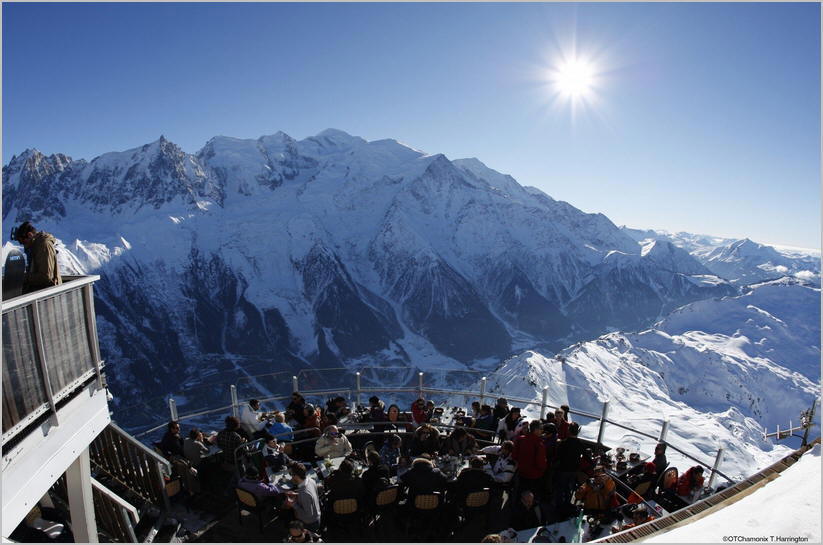 An image from Chamonix-Mont-Blanc, France
.
.
Click the link below for images:
.
__________________________________________
November 29, 2022
Mohenjo
Business, Enthralling, Human Interest, Photographs
amazon, business, Business News, current-events, Future, Hotels, human-rights, medicine, mental-health, research, Science, Science News, technology, Technology News, travel, vacation
Click the link below the picture
.
Palm Springs is a desert resort city in Riverside County, California, United States, within the Colorado Desert’s Coachella Valley. The city covers approximately 94 square miles (240 km2), making it the largest city in Riverside County by land area. With multiple plots in a checkerboard pattern, more than 10% of the city is part of the Agua Caliente Band of Cahuilla Indians reservation land and is the administrative capital of the most populated reservation in California.
The population of Palm Springs was 44,575 as of the 2020 census, but because Palm Springs is a retirement location and a winter snowbird destination, the city’s population triples between November and March.
The city is noted for its mid-century modern architecture, design elements, arts and cultural scene, and recreational activities.
The first humans to settle in the area were the Cahuilla people, who arrived 2,000 years ago. Cahuilla Indians lived here in isolation from other cultures for hundreds of years prior to European contact. They spoke Ivilyuat, which is a Uto-Aztecan language. Numerous prominent and powerful Cahuilla leaders were from the area, including Cahuilla Lion (Chief Juan Antonio). While Palm Canyon was occupied during the winter months, they often moved to cooler Chino Canyon during the summer months. Wikipedia
.
 An image from Desert Golf Course Palm Springs
.
.
Click the link below for images:
.
__________________________________________
November 28, 2022
Mohenjo
Business, Enthralling, Human Interest, Photographs
amazon, business, Business News, current-events, Future, Hotels, human-rights, medicine, mental-health, research, Science, Science News, technology, Technology News, travel, vacation
Click the link below the picture
.
Man o’ War Cove (or Man of War Bay and similar names) lies on the Dorset coast in southern England and is flanked by the rocky, steep, and slightly projecting headlands of Durdle Door to the west and Man O War (or O’ War) Head to the east.
A line of pronounced rocks takes up the far side of the cove at the distance of the great Durdle Door headland to the east; these partially enclose the cove, and have few submerged components, and feature mostly at the east end of the bay — map-recorded as “The Man o’ War”. The line of exposed rocks continues, very intermittently about 100 meters from the shore as the Norman Rock, Pinion Rock, and a cluster around the Ball Stone, along St Oswald’s Bay. It is usually possible to walk along a thin strand of high tide, dry sand linking the cove to the rest of St Oswald’s Bay an area almost entirely visible from the west side of the cove.
The UK Ordnance Survey maps have local bay names at 1:50000 and 1:25000; these record the pronounced crescent as Man o’ War Cove, in turn forming part of St Oswald’s Bay reduced to a long gentle arc to the east, about five times the width of the cove. A technical distinction is possible as to the water rather than the solid features of the crescent, in that the cove the bay encloses is Man o’ War Cove. St Oswald’s Bay is in turn protected from Atlantic surf by south Devon and by closer Portland Bill forming the multi-cove Weymouth Bay, before the even greater recess of Christchurch or Poole Bay which in its greater definition takes in the area of sea east of Swanage on the Purbeck peninsula.
There is a paid parking lot available 300 meters away from the cove. It is also connected to the South West Coast Path, so it is possible to park elsewhere along the trail and access the cove by foot. Wikipedia
.
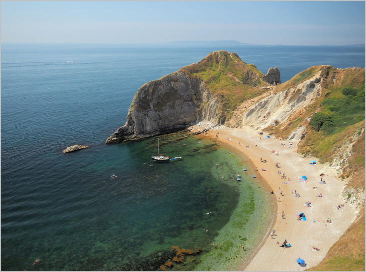 An image from Man of War Bay on the Dorset coast of England
.
.
Click the link below for images:
.
__________________________________________
November 25, 2022
Mohenjo
Business, Enthralling, Human Interest, Photographs
amazon, business, Business News, current-events, Future, Hotels, human-rights, medicine, mental-health, research, Science, Science News, technology, Technology News, travel, vacation
Click the link below the picture
.
Durdle Door (sometimes written Durdle Dor) is a natural limestone arch on the Jurassic Coast near Lulworth in Dorset, England. It is privately owned by the Weld Family who own the Lulworth Estate, but it is also open to the public.
The form of the coastline around Durdle Door is controlled by its geology—both by the contrasting hardnesses of the rocks and by the local patterns of faults and folds. The arch has formed on a concordant coastline where bands of rock run parallel to the shoreline. The rock strata are almost vertical, and the bands of rock are quite narrow. Originally a band of resistant Portland limestone ran along the shore, the same band that appears one mile along the coast forming the narrow entrance to Lulworth Cove. Behind this is a 120-meter (390 ft) band of weaker, easily eroded rocks, and behind this is a stronger and much thicker band of chalk, which forms the Purbeck Hills. These steeply dipping rocks are part of the Lulworth crumple, itself part of the broader Purbeck Monocline, produced by the building of the Alps during the mid-Cenozoic.
A ‘back view’ of the Durdle Door promontory from the east, showing the remnants of the more resistant strata in Man O’War Bay
The limestone and chalk are in closer proximity at Durdle Door than at Swanage, 10 miles (16 km) to the east, where the distance is over 2 miles (3 km). Around this part of the coast, nearly all of the limestone has been removed by sea erosion, whilst the remainder forms the small headland which includes the arch. Erosion at the western end of the limestone band has resulted in the arch formation. UNESCO teams monitor the condition of both the arch and adjacent beach.
The 120-meter (390 ft) isthmus that joins the limestone to the chalk is made of a 50-meter (160 ft) band of Portland limestone, a narrow and compressed band of Cretaceous Wealden clays and sands, and then narrow bands of greensand and sandstone.
In Man O’ War Bay, the small bay immediately east of Durdle Door, the band of Portland and Purbeck limestone has not been entirely eroded away and is visible above the waves as Man O’War Rocks. Similarly, offshore to the west, the eroded limestone outcrop forms a line of small rocky islets called (from east to west) The Bull, The Blind Cow, The Cow, and The Calf.
As the coastline in this area is generally an eroding landscape, the cliffs are subject to occasional rockfalls and landslides; a particularly large slide occurred just to the east of Durdle Door in April 2013, resulting in destruction of part of the South West Coast Path. Wikipedia
.
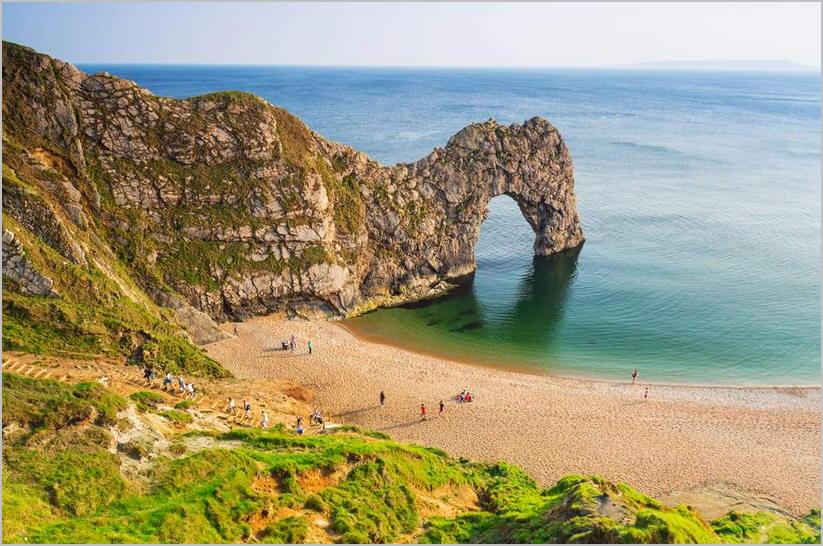 An image of Durdle Door Jurassic Coast Dorset
.
.
Click the link below for images:
.
__________________________________________
November 23, 2022
Mohenjo
Business, Enthralling, Human Interest, Photographs
amazon, business, Business News, current-events, Future, Hotels, human-rights, medicine, mental-health, research, Science, Science News, technology, Technology News, travel, vacation
Click the link below the picture
.
Tegallalang is a district in the Gianyar Regency, Bali, Indonesia. As of the 2010 census, the area was 61.80 km2 and the population was 50,625; the latest official estimate (as at mid 2019) is 53,760. Located around 10 km north of Ubud, its terraced rice fields are a tourist attraction in the area.
.
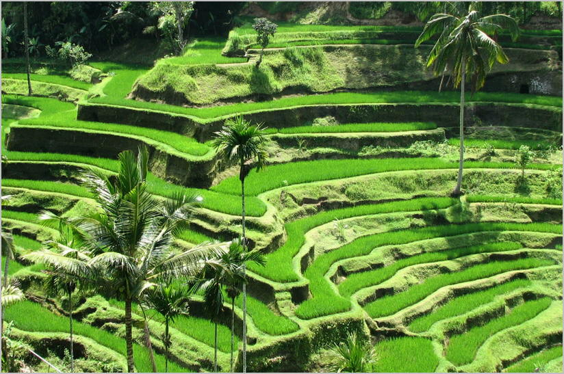 An image of a Bali Rice Terrace
.
.
Click the link below for images:
.
__________________________________________
November 22, 2022
Mohenjo
Business, Enthralling, Human Interest, Photographs
amazon, business, Business News, current-events, Future, Hotels, human-rights, medicine, mental-health, research, Science, Science News, technology, Technology News, travel, vacation
Click the link below the picture
.
Cape Royal is a 7,880+ cliff elevation summit located in the eastern Grand Canyon, Coconino County of northern Arizona, United States. It is the southernmost viewpoint of the North Rim, viewing from north-northeast, south, west, southwest. Its next viewpoint northwest is Honan Point, with Thor Temple directly below. Directly east-northeast is the major viewing point of Cape Final, which gives views almost directly north. The 1/2 mile Cape Royal Trail starts at the parking lot and ends at the overlook at Cape Royal.
From Cape Royal, directly southeast can be seen the massif and highpoint of Freya Castle, and southeasterly is massive Wotans Throne, which is a surviving section of the North Rim, with a Ponderosa Pine, forested, flat prominence. The cliffs of Cape Royal are composed of Kaibab Limestone, on erodible Toroweap Formation, upon white cliffs of Coconino Sandstone. The watershed drainage from Cape Royal, overlooks the Unkar Creek and Canyon to the south into the Colorado River, about 6 miles distant.
.
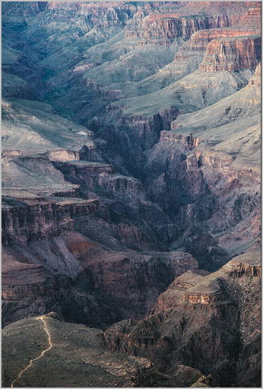 A View of the Grand Canyon from Cape Royal, Arizona
.
.
Click the link below for images:
.
__________________________________________
November 18, 2022
Mohenjo
Business, Enthralling, Human Interest, Photographs
amazon, business, Business News, current-events, Future, Hotels, human-rights, medicine, mental-health, research, Science, Science News, technology, Technology News, travel, vacation
Click the link below the picture
.
Glen Etive is a glen in the Highlands of Scotland. The River Etive (Scottish Gaelic: Abhainn Èite) rises on the peaks surrounding Rannoch Moor, with several tributary streams coming together at the Kings House Hotel, at the head of Glen Coe. From the Kings House, the Etive flows for about 18 km, reaching the sea loch, Loch Etive. The river and its tributaries are popular with whitewater kayakers and at high water levels, it is a test piece of the area and a classic run.
At the north end of Glen Etive lie the two mountains known as the “Herdsmen of Etive”: Buachaille Etive Mòr and Buachaille Etive Beag. Other peaks accessible from the Glen include Ben Starav, located near the head of Loch Etive, and Beinn Fhionnlaidh on the northern side of the glen. The scenic beauty of the glen has led to its inclusion the Ben Nevis and Glen Coe National Scenic Area, one of 40 such areas in Scotland.
A narrow road from the Kings House Hotel runs down the glen, serving several houses and farms. This road ends at the head of the loch, though rough tracks continue along both shores.
The River Etive is one of Scotland’s most popular and challenging whitewater kayaking runs. It provides a multitude of solid Grade 4(5) rapids with a variety of falls and pool drops. It is home to a herd of Scottish red deer that have become accustomed to the presence of humans.
In the Ulster Cycle of Irish mythology, Deirdre and her love Naoise founded Glen Etive after fleeing Ulster.
The Fachen is also known as the Dwarf of Glen Etive.
Glen Etive has been used as the backdrop to many movies, among them Braveheart and Skyfall. The resulting influx of visitors has led to concerns about the spoilage of the glen through littering and fly-tipping.
.
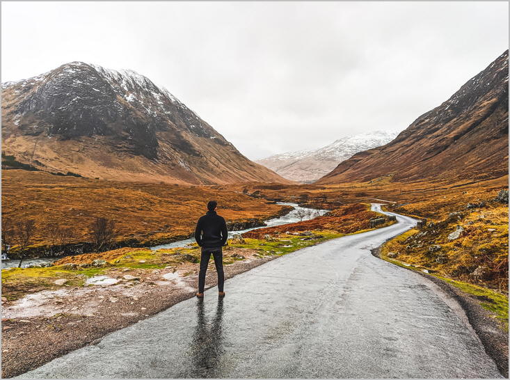 An image from Glen Etive
.
.
Click the link below for images:
.
__________________________________________
November 16, 2022
Mohenjo
Business, Enthralling, Human Interest, Photographs
amazon, business, Business News, current-events, Future, Hotels, human-rights, medicine, mental-health, research, Science, Science News, technology, Technology News, travel, vacation
Click the link below the picture
.
The Artemis program is a robotic and human Moon exploration program led by the United States’ National Aeronautics and Space Administration (NASA) with three partner agencies: European Space Agency (ESA), Japan Aerospace Exploration Agency (JAXA), and Canadian Space Agency (CSA). If successful, the Artemis program will reestablish a human presence on the Moon for the first time since the Apollo 17 mission in 1972. The major components of the program are the Space Launch System (SLS), Orion spacecraft, Lunar Gateway space station, and the commercial Human Landing Systems, including Starship HLS. The program’s long-term goal is to establish a permanent base camp on the Moon and facilitate human missions to Mars.
The Artemis program is a collaboration of government space agencies and private spaceflight companies, bound together by the Artemis Accords and supporting contracts. As of July 2022, twenty-one countries have signed the accords, including traditional U.S. space partners (such as the European Space Agency as well as agencies from Canada, Japan, and the United Kingdom) and emerging space powers such as Brazil, South Korea, and the United Arab Emirates.
The Artemis program was formally established in 2017 during the Trump administration; however, many of its components such as the Orion spacecraft were developed during the previous Constellation program (2005–2010) during the Bush administration, and after its cancellation during the Obama administration. Orion’s first launch, and the first use of the Space Launch System, was originally set in 2016 but was rescheduled and launched on 16 November 2022 as the Artemis 1 mission, with robots and mannequins aboard. According to plan, the crewed Artemis 2 launch will take place in 2024, the Artemis 3 crewed lunar landing in 2025, the Artemis 4 docking with the Lunar Gateway in 2027, and future yearly landings on the Moon thereafter. However, some observers note that the program’s cost and timeline are likely to be overrun and delayed due to, according to internal and external review, NASA’s inadequate management of contractors.
.
 An image of Nasa Artemis Launch
.
.
Click the link below for images:
.
__________________________________________
November 14, 2022
Mohenjo
Business, Enthralling, Human Interest, Photographs
amazon, business, Business News, current-events, Future, Hotels, human-rights, medicine, mental-health, research, Science, Science News, technology, Technology News, travel, vacation
Click the link below the picture
.
Ubud is a town on the Indonesian island of Bali in Ubud District, located amongst rice paddies and steep ravines in the central foothills of the Gianyar regency. Promoted as an arts and culture center, it has developed a large tourism industry. It forms a northern part of the Greater Denpasar metropolitan area (known as Sarbagita).
Ubud, often mistaken for a small city, is an administrative district (kecamatan) with a population of 74,800 (as of the 2020 Census) in an area of 42.38 km2. The central area of Ubud desa (village) has a population of 11,971 and an area of 6.76 km2, and receives more than three million foreign tourists each year. The area surrounding the town is made up of small farms, rice paddies, agroforestry plantations, and tourist accommodations. As of 2018, more tourists visited Ubud than Denpasar in south.
Eighth-century legend tells of a Javanese priest, Rsi Markendya, who meditated at the confluence of two rivers (an auspicious site for Hindus) at the Ubud locality of Campuhan. Here he founded the Gunung Lebah Temple on the valley floor, the site of which remains a pilgrim destination.
The town was originally important as a source of medicinal herbs and plants; Ubud gets its name from the Balinese word ubad (medicine).
In the late 19th century, Ubud became the seat of feudal lords who owed their allegiance to the king of Gianyar, at one time the most powerful of Bali’s southern states. The lords were members of the Balinese Kshatriya caste of Suk and were significant supporters of the village’s increasingly renowned arts scene.
Antonio Blanco, a Spanish-American artist, lived in Ubud from 1952 until his death in 1999. A new burst of creative energy came in the 1960s after the arrival of Dutch painter Arie Smit and the development of the Young Artists Movement. The Bali tourist boom since the late 1960s has seen much development in the town.
In 2002, terrorist bombings caused a decline in tourism throughout Bali including Ubud. In response to this, a writer’s festival was created, Ubud Writers and Readers Festival to help revive tourism, the island’s main economic lifeline.
The main street is Jalan Raya Ubud (Jalan Raya means main road), which runs east-west through the center of town. Two long roads, Jalan Monkey Forest and Jalan Hanoman extend south from Jalan Raya Ubud. Wikipedia
.
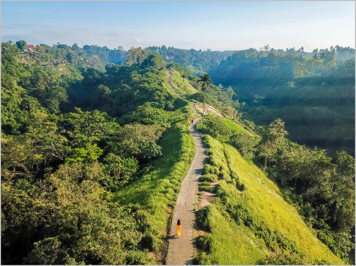 An image of Campuhan Ridge Walk Ubud
.
.
Click the link below for images:
.
__________________________________________
Older Entries
Newer Entries
