January 24, 2022
Mohenjo
Business, Enthralling, Human Interest, Photographs
amazon, business, Business News, current-events, Future, Hotels, human-rights, medicine, mental-health, research, Science, Science News, technology, Technology News, travel, vacation

Click the link below the picture
.
Bulgaria, officially the Republic of Bulgaria, is a country in Southeast Europe. It occupies the whole eastern part of the Balkans and is bordered by Romania to the north, Serbia and North Macedonia to the west, Greece and Turkey to the south, and the Black Sea to the east. Bulgaria covers a territory of 110,994 square kilometers (42,855 sq mi), and is the sixteenth largest country in Europe. Sofia is the nation’s capital and largest city; other major cities are Plovdiv, Varna, and Burgas.
One of the earliest societies in the lands of modern-day Bulgaria was the Neolithic Karanovo culture, which dates back to 6,500 BC. In the 6th to 3rd century BC, the region was a battleground for ancient Thracians, Persians, Celts, and Ancient Macedonians; stability came when the Roman Empire conquered the region in AD 45. After the Roman state splintered, tribal invasions in the region resumed. Around the 6th century, these territories were settled by the early Slavs. The Bulgars led by Asparuh of Bulgaria attacked from the lands of (Old Great) Bulgaria and permanently invaded the Balkans in the late 7th century. They established (Danubian) Bulgaria, victoriously recognized by treaty in AD 681 by the Eastern Roman Empire. It dominated most of the Balkans and significantly influenced Slavic cultures by developing the Cyrillic script. The First Bulgarian Empire lasted until the early 11th century when Byzantine emperor Basil II conquered and dismantled it. A successful Bulgarian revolt in 1185 established a Second Bulgarian Empire, which reached its apex under Ivan Asen II (1218–1241). After numerous exhausting wars and feudal strife, the empire disintegrated in 1396 and fell under Ottoman rule for nearly five centuries.
The Russo-Turkish War of 1877–78 resulted in the formation of the third and current Bulgarian state. Many ethnic Bulgarians were left outside the new nation’s borders, which stoked irredentist sentiments that led to several conflicts with its neighbors and alliances with Germany in both world wars. In 1946, Bulgaria came under the Soviet-led Eastern Bloc and became a socialist state. The ruling Communist Party gave up its monopoly on power after the revolutions of 1989 and allowed multiparty elections. Bulgaria then transitioned into a democracy and a market-based economy. Since adopting a democratic constitution in 1991, Bulgaria has been a unitary parliamentary republic composed of 28 provinces, with a high degree of political, administrative, and economic centralization.
Bulgaria is a developing country, with an upper-middle-income economy, ranking 56th in the Human Development Index. Its market economy is part of the European Single Market and is largely based on services, followed by industry—especially machine building and mining—and agriculture. Widespread corruption is a major socioeconomic issue; Bulgaria ranked as the most corrupt country in the European Union in 2018. The country also faces a demographic crisis, with its population shrinking annually since around 1990; it currently numbers roughly seven million, down from a peak of nearly nine million in 1988. Bulgaria is a member of the European Union, NATO, and the Council of Europe; it is also a founding member of the OSCE and has taken a seat on the United Nations Security Council three times. Wikipedia
.
 An image from Bulgaria
.
.
Click the link below for images:
.
__________________________________________
January 22, 2022
Mohenjo
Business, Enthralling, Human Interest, Photographs
amazon, business, Business News, current-events, Future, Hotels, human-rights, medicine, mental-health, research, Science, Science News, technology, Technology News, travel, vacation
Click the link below the picture
.
Logan is a city in Hocking County, Ohio. The population was 7,152 at the time of the 2010 census. It is the county seat of Hocking County. Logan is located in southeast Ohio, on the Hocking River 48 miles southeast of Columbus. The current mayor of Logan is Republican Greg Fraunfelter, who began a four-year term in January 2016 and was re-elected in 2019.
Logan is the county seat of Hocking County, Ohio. Residents named the town in honor of Chief Logan of the Mingo Indian tribe. He and his band lived in this area at the time of European-American settlement. Ohio Governor Thomas Worthington established the community in 1816.
Logan was incorporated as a city in 1839.
Logan was the first city in the state of Ohio to install a double roundabout. Located at the interchange of Ohio State Route 664 and U.S. Route 33, the roundabouts were officially opened to traffic on December 4, 2013.
According to the United States Census Bureau, the city has a total area of 4.93 square miles (12.77 km2), of which 4.79 square miles (12.41 km2) is land and 0.14 square miles (0.36 km2) is water.
As of the census of 2010, there were 7,152 people, 2,982 households, and 1,831 families residing in the city. The population density was 1,493.1 inhabitants per square mile (576.5/km2). There were 3,374 housing units at an average density of 704.4 per square mile (272.0/km2). The racial makeup of the city was 97.5% White, 0.8% African American, 0.3% Native American, 0.2% Asian, 0.3% from other races, and 0.9% from two or more races. Hispanic or Latino of any race were 0.8% of the population. Wikipedia
.
 An image from Logan, Ohio
.
.
Click the link below for images:
.
__________________________________________
January 20, 2022
Mohenjo
Business, Enthralling, Human Interest, Photographs
amazon, business, Business News, current-events, Future, Hotels, human-rights, medicine, mental-health, research, Science, Science News, technology, Technology News, travel, vacation
Click the link below the picture
.
A gazelle is any of many antelope species in the genus Gazella. This article also deals with the seven species included in two further genera, Eudorcas and Nanger, which were formerly considered subgenera of Gazella. A third former subgenus, Procapra, includes three living species of Asian gazelles.
Gazelles are known as swift animals. Some are able to run at bursts as high as 100 km/h (60 mph) or run at a sustained speed of 50 km/h (30 mph).[1] Gazelles are found mostly in the deserts, grasslands, and savannas of Africa; but they are also found in southwest and central Asia and the Indian subcontinent. They tend to live in herds, and eat less coarse, easily digestible plants and leaves.
Gazelles are relatively small antelopes, most standing 60–110 cm (2–3.5 ft) high at the shoulder, and are generally fawn-colored.
The gazelle genera are Gazella, Eudorcas, and Nanger. The taxonomy of these genera is confused, and the classification of species and subspecies has been an unsettled issue. Currently, the genus Gazella is widely considered to contain about 10 species. One species is extinct: the Queen of Sheba’s gazelle. Most surviving gazelle species are considered threatened to varying degrees. Closely related to the true gazelles are the Tibetan Goa and Mongolian gazelles (species of the genus Procapra), the blackbuck of Asia, and the African springbok.
One widely familiar gazelle is the African species Thomson’s gazelle (Eudorcas thomsoni), which is around 60 to 70 cm (24 to 28 in) in height at the shoulder and is coloured brown and white with a distinguishing black stripe. The males have long, often curved, horns. Like many other prey species, Tommies and springboks (as they are familiarly called) exhibit a distinctive behaviour of stotting (running and jumping high before fleeing) when they are threatened by predators, such as cheetahs, lions, African wild dogs, crocodiles, hyenas, and leopards.
Gazelle is derived from Arabic: غزال ġazāl, Maghrebi pronunciation ġazēl. To Europe it first came to Old Spanish and Old French, and then around 1600 the word entered the English language. The Arab people traditionally hunted the gazelle. Appreciated for its grace, it is a symbol most commonly associated in Arabic literature with female beauty. In many countries in Northwestern Sub-Saharan Africa, the gazelle is commonly referred to as “dangelo”, meaning “swift deer”. Wikipedia
.
 An image of Gazelles
.
.
Click the link below for images:
.
__________________________________________
January 19, 2022
Mohenjo
Business, Enthralling, Human Interest, Photographs
amazon, business, Business News, current-events, Future, Hotels, human-rights, medicine, mental-health, research, Science, Science News, technology, Technology News, travel, vacation
Click the link below the picture
.
Düsseldorf is the capital city of North Rhine-Westphalia, the most populous state of Germany. It is the second-largest city in the state and the seventh-largest city in Germany, with a population of 617,280.
Düsseldorf is located at the confluence of two rivers: the Rhine and the Düssel, a small tributary. The -dorf suffix means “village” in German (English cognate: thorp); its use is unusual for a settlement as large as Düsseldorf. Most of the city lies on the right bank of the Rhine (unlike Cologne, which is on the river’s left bank). Düsseldorf lies in the centre of both the Rhine-Ruhr and the Rhineland Metropolitan Region. It neighbours the Cologne Bonn Region to the south and the Ruhr to the north. It is the largest city in the German Low Franconian dialect area (closely related to Dutch).
Mercer’s 2012 Quality of Living survey ranked Düsseldorf the sixth most livable city in the world. Düsseldorf Airport is Germany’s third-busiest airport after those of Frankfurt and Munich, serving as the most important international airport for the inhabitants of the densely populated Ruhr, Germany’s largest urban area. Düsseldorf is an international business and financial centre, renowned for its fashion and trade fairs, and is headquarters to one Fortune Global 500 and two DAX companies. Messe Düsseldorf organises nearly one fifth of premier trade shows. As second largest city of the Rhineland, Düsseldorf holds Rhenish Carnival celebrations every year in February/March, the Düsseldorf carnival celebrations being the third most popular in Germany after those held in Cologne and Mainz.
There are 22 institutions of higher education in the city including the Heinrich-Heine-Universität Düsseldorf, the university of applied sciences (Hochschule Düsseldorf), the academy of arts (Kunstakademie Düsseldorf, whose members include Joseph Beuys, Emanuel Leutze, August Macke, Gerhard Richter, Sigmar Polke, and Andreas Gursky), and the university of music (Robert-Schumann-Musikhochschule Düsseldorf). The city is also known for its influence on electronic/experimental music (Kraftwerk) and its Japanese community. Düsseldorf is classified as a GaWC Beta+ world city.
When the Roman Empire was strengthening its position throughout Europe, a few Germanic tribes clung on in marshy territory off the eastern banks of the Rhine. In the 7th and 8th centuries, the odd farming or fishing settlement could be found at the point where the small river Düssel flows into the Rhine. It was from such settlements that the city of Düsseldorf grew. The first written mention of Düsseldorf (then called Dusseldorp in the local Low Rhenish dialect) dates back to 1135. Under Emperor Friedrich Barbarossa the small town of Kaiserswerth to the north of Düsseldorf became a well-fortified outpost, where soldiers kept a watchful eye on every movement on the Rhine. Kaiserswerth eventually became a suburb of Düsseldorf in 1929. In 1186, Düsseldorf came under the rule of the Counts of Berg. 14 August 1288 is one of the most important dates in the history of Düsseldorf. On this day the sovereign Count Adolf VIII of Berg granted the village on the banks of the Düssel town privileges. Before this, a bloody struggle for power had taken place between the Archbishop of Cologne and the count of Berg, culminating in the Battle of Worringen. Wikipedia
.
 An image from Dusseldorf, Germany
.
.
Click the link below for images:
.
__________________________________________
January 18, 2022
Mohenjo
Business, Enthralling, Human Interest, Photographs
amazon, business, Business News, current-events, Future, Hotels, human-rights, medicine, mental-health, research, Science, Science News, technology, Technology News, travel, vacation
Click the link below the picture
.
Fairy Falls is a 20-foot waterfall on the Oregon side of the Columbia River Gorge in the United States. As part of a tributary of Wahkeena Creek, Fairy Falls is located upstream from the much larger Wahkeena Falls. While small, this fan-shaped waterfall is a destination for photographers, mainly because of the scenic view. The creek cascades through a mossy rock slide lined with ferns, until rocky ledges of basalt break the water into various lacy streams. Wikipedia
.
 An image of Fairy Falls Columbia River Gorge
.
.
Click the link below for images:
.
__________________________________________
January 17, 2022
Mohenjo
Business, Enthralling, Human Interest, Photographs
amazon, business, Business News, current-events, Future, Hotels, human-rights, medicine, mental-health, research, Science, Science News, technology, Technology News, travel, vacation
Click the link below the picture
.
Maceió, formerly sometimes Anglicised as Macaio, is the capital and the largest city of the coastal state of Alagoas, Brazil. The name “Maceió” is an Indigenous term for a spring. Most maceiós flow to the sea, but some get trapped and form lakes (“lagoas”, in Portuguese).
There are numerous maceiós and lakes in this part of Brazil; because of this, the city was named Maceió, and the state, Alagoas. The new Zumbi dos Palmares International Airport connects Maceió with many Brazilian cities and also operates some international flights. The city is home to the Federal University of Alagoas.
The name “Maceió” has origin in the term tupi maçayó or maçaio-k, which means “what it covers the swamp”. The Aurélio Dictionary says that the term “maceió” means a temporary and cyclic lagoon that is located at the edge of the sea at the mouth of a watercourse small enough to be interrupted by a silicate bar until the high tide opens the way temporarily cyclically related to the season, river flow, lunar seasons, etc.
Nineteenth-century shipping reports, which reported on ships bringing cotton from Maceió, spelt it as Macaio.
The city began in an old sugar mill and plantation complex around the 19th century. Its development started with the arrival of ships taking wood from Jaraguá bay.
With the installation of the sugar mills, Maceió started to export sugar, then tobacco, coconut, leather, and some spices. Prosperity made it possible for the settlement to become a village on December 5, 1815. Thanks to its continued growth, Maceió became the capital of the Alagoas state on December 9, 1839.
Maceió is also a port city and due to its port development about 200 years ago it changed from a village into a city.
The city is located between the Mundaú Lagoon and the Atlantic Ocean, with a tropical climate with average temperature of 25 °C (77 °F). As of 2010, its metropolitan area had a total population of 1,156,287 inhabitants. Wikipedia
.
 An image from Maceió
.
.
Click the link below for images:
.
__________________________________________
January 15, 2022
Mohenjo
Business, Enthralling, Human Interest, Photographs
amazon, business, Business News, current-events, Future, Hotels, human-rights, medicine, mental-health, research, Science, Science News, technology, Technology News, travel, vacation
Click the link below the picture
.
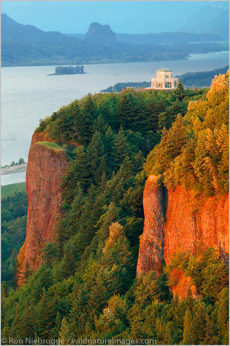
The Columbia River Gorge is a canyon of the Columbia River in the Pacific Northwest of the United States. Up to 4,000 feet (1,200 m) deep, the canyon stretches for over eighty miles (130 km) as the river winds westward through the Cascade Range, forming the boundary between the state of Washington to the north and Oregon to the south. Extending roughly from the confluence of the Columbia with the Deschutes River (and the towns of Roosevelt, Washington, and Arlington, Oregon) in the east down to the eastern reaches of the Portland metropolitan area, the water gap furnishes the only navigable route through the Cascades and the only water connection between the Columbia Plateau and the Pacific Ocean. It is thus the route of Interstate 84, U.S. Route 30, Washington State Route 14, and railroad tracks on both sides.
A popular recreational destination, the gorge holds federally protected status as the Columbia Gorge National Scenic Area and is managed by the Columbia River Gorge Commission and the U.S. Forest Service.
The Columbia River, Klamath River in northern California, Pit River in northern California, and Fraser River in southern British Columbia are the only four rivers connecting the watersheds on the east side of the Cascade Range to the Pacific Ocean. Each river has created a gorge through the Cascades. The Columbia River Gorge marks the state line between Oregon and Washington, and its wide range of elevation and precipitation makes it an extremely diverse and dynamic place. Ranging from 4,000 feet (1,200 m) to sea level, and transitioning from 100 inches (2,500 mm) of precipitation to only 10 inches (250 mm) in 80 miles (130 km), the gorge creates a diverse collection of ecosystems, from the temperate rain forest on the western end—with an average annual precipitation of 75 to 100 inches (1,900 to 2,500 mm)—to the eastern grasslands with average annual precipitation between 10 and 15 inches (250 and 380 mm), to a transitional dry woodland between Hood River and The Dalles.[citation needed] Isolated micro-habitats have allowed for many species of endemic plants and animals to prosper, including at least 13 endemic wildflowers.
The gorge transitions between temperate rainforest to dry grasslands in only 80 miles (130 km), hosting a dramatic change in scenery while driving along Interstate 84. In the western, temperate rainforest areas, forests are marked by bigleaf maples, Douglas fir, and western hemlock, all covered in epiphytes. In the transition zone (between Hood River and The Dalles), vegetation turns to Oregon white oak, ponderosa pine, and cottonwood. At the eastern end, the forests make way for expansive grasslands, with occasional pockets of lodgepole and ponderosa pine. Wikipedia
.
 An image from Columbia River Gorge
.
.
Click the link below for images:
.
__________________________________________
January 14, 2022
Mohenjo
Business, Enthralling, Human Interest, Photographs
amazon, business, Business News, current-events, Future, Hotels, human-rights, medicine, mental-health, research, Science, Science News, technology, Technology News, travel, vacation
Click the link below the picture
.
Guatapé is a town and municipality in the Department of Antioquia, Colombia. It is a part of the subregion of Eastern Antioquia and is located 79 kilometers (49 mi) from Medellín, the capital of the department. Guatapé is bordered on the north by Alejandría, San Rafael to the east, and Granada and El Peñol to the south. This town is the gathering place for Las Vegas, referring to the small farms of the area.
The town is a major tourist attraction, especially for travelers from Medellín. El Peñón de Guatapé, a large rock that visitors can climb, and the famous zócalos (murals) that adorn several buildings attract many tourists.
Before Iberian conquistadors reached the area in the 16th century, this territory was inhabited by indigenous groups, some controlled by a cacique named Guatape. In his honor, the town was named after him. The name “Guatapé”, comes from the Quechua language, related to “stones and water”. Another name that the town had in the past was “La Ceja de Guatapé”.
In 1714, the indigenous people under Guatapé of this region were grouped into a shelter known as “San Antonio de Remolinos Peñol”. Traces of their existence come from clay urns found in the town of Alto Verde, and several archaeological sites not yet studied in the villages of La Peña, La Piedra, El Roble, and El Rosario.
Guatapé was founded 4 October 1811, by the Spaniard Don Francisco Giraldo y Jimenez. It was declared a municipality in September 1867.
Guatapé has undergone changes throughout its history. It was predominately a farming town that relied on livestock, agriculture, and mining. Empresas Públicas de Medellín built a large hydroelectric complex here in the 1970s. This megaproject produced large impacts on social, economic, political, environmental, and cultural development in the locality. With the construction of this dam, Guatapé became one of the most important electric production centers in the country. Wikipedia
.
 An image from Guatape, Colombia
.
.
Click the link below for images:
.
__________________________________________
January 13, 2022
Mohenjo
Business, Enthralling, Human Interest, Photographs
amazon, business, Business News, current-events, Future, Hotels, human-rights, medicine, mental-health, research, Science, Science News, technology, Technology News, travel, vacation
Click the link below the picture
.
The Valle Verzasca is a valley in the Locarno district of the Canton of Ticino, Switzerland. It comprises the municipalities of Mergoscia, Vogorno, Corippo, Lavertezzo, Brione, Gerra, Frasco, and Sonogno. As of 2004, the total population is 3,200. Mergoscia is at the geographical center of the Ticino, and none of the passes out of the valley cross cantonal or national borders. The valley is formed by the Verzasca River and is situated between the Leventina and the Maggia and culminates at Pizzo Barone.
Located between the Leventina and the Valle Maggia valleys, Valle Verzasca extends over a length of 25 kilometers (16 mi) in a north-south direction and is situated in the north of the Lago Maggiore. The valley floor is at about 500 meters (1,640 ft) to 900 meters (2,953 ft)above sea level. The surrounding mountain passes respectively have an average altitude of 2,400 meters (7,874 ft). The Valley is crossed by the Verzasca river which is dammed at the southernly outlet of the Valley, forming the Lago di Vogorno, before it flows in the Magadino plain in the vicinity of the Ticino River in the Lago Maggiore.
Due to the different altitudes, all climate zones are combined in the Valle Verzasca. Tenero-contra and Gordola include the insubric climate region thanks to the deep sea level, close to the Lago Maggiore, and protected by the mountains from the north winds. Vineyards and Mediterranean vegetation benefit from the mildest climate area of Switzerland, nebulae are rare, and rainfall of short duration. With increasing altitude, the hills and mountain climate goes over to regions dominated by the Alpine climate (over 2,000 meters (6,562 ft)).
The diversity benefits among other things, the cultivation of vines, and it flourish chestnut forests and palm trees thrive. Due to differences in soil type and amounts, almost all flora occurring in the Ticino and fauna of the various environmental zones are found in the Verzasca Valley.
The Romans introduced and comparable to the tropical wood species, Castanea sativa is in the southern part of the valley, below 1,000 meters (3,281 ft), the dominant species. It is no longer actively cultivated but favors the further diffusion, and studies suggest to take advantage of the valuable wood of chestnut as a valuable wood.
In the Valle Verzasca, the endemic Nera Verzasca goat has been preserved, which looks very much like the ancient Roman goat. This medieval durable goat has short hair because it’s not stuck in the snow. Wikipedia
.
 An image from Lavertezzo, Valle Verzasca, Verzasca Valley, Ticino, Switzerland, Europe
.
.
Click the link below for article:
.
__________________________________________
January 12, 2022
Mohenjo
Business, Enthralling, Human Interest, Photographs
amazon, business, Business News, current-events, Future, Hotels, human-rights, medicine, mental-health, research, Science, Science News, technology, Technology News, travel, vacation
Click the link below the picture
.
Aït Benhaddou is a historic ighrem or ksar (fortified village) along the former caravan route between the Sahara and Marrakech in present-day Morocco. It is considered a great example of Moroccan earthen clay architecture and has been a UNESCO World Heritage Site since 1987.
The site of the ksar has been fortified since the 11th century during the Almoravid period. None of the current buildings are believed to date from before the 17th century, but they were likely built with the same construction methods and designs as had been used for centuries before. The site’s strategic importance was due to its location in the Ounila Valley along one of the main trans-Saharan trade routes. The Tizi n’Tichka pass, which was reached via this route, was one of the few routes across the Atlas Mountains, crossing between Marrakech and the Dra’a Valley on the edge of the Sahara. Other kasbahs and ksour were located all along this route, such as the nearby Tamdaght to the north.
Today, the ksar itself is only sparsely inhabited by several families. The depopulation over time is a result of the valley’s loss of strategic importance in the 20th century. Most local inhabitants now live in modern dwellings in the village on the other side of the river, and make a living off agriculture and especially off the tourist trade. In 2011 a new pedestrian bridge was completed linking the old ksar with the modern village, with the aim of making the ksar more accessible and to potentially encourage inhabitants to move back into its historic houses.
The ksar is located on the slopes of a hill next to the Ounila River (Asif Ounila). The village’s buildings are grouped together within a defensive wall that includes corner towers and a gate. They include dwellings of various sizes ranging from modest houses to tall structures with towers. Some of the buildings are decorated in their upper parts with geometric motifs. The village also has a number of public or community buildings such as a mosque, a caravanserai, a kasbah (castle-like fortification), and the Marabout of Sidi Ali or Amer. At the top of the hill, overlooking the ksar, are the remains of a large fortified granary (agadir). There is also a public square, a Muslim cemetery, and a Jewish cemetery. Outside the ksar’s walls was an area where grain was grown and threshed. Wikipedia
.
 An image of Ait Benhaddou
.
.
Click the link below for images:
.
__________________________________________
Older Entries
Newer Entries
