April 15, 2022
Mohenjo
Business, Enthralling, Human Interest, Photographs
amazon, business, Business News, current-events, Future, Hotels, human-rights, medicine, mental-health, research, Science, Science News, technology, Technology News, travel, vacation

Click the link below the picture
.
The muskox also spelled musk ox and musk-ox, plural muskoxen or musk oxen, is a hoofed mammal of the family Bovidae. Native to the Arctic, it is noted for its thick coat and for the strong odor emitted by males during the seasonal rut, from which its name derives. This musky odor has the effect of attracting females during mating season. Its Inuktitut name “umingmak” translates to “the bearded one”. Its Woods Cree names “mâthi-môs” and “mâthi-mostos” translate to “ugly moose” and “ugly bison”, respectively. Muskoxen primarily live in Greenland and the Canadian Arctic of the Northwest Territories and Nunavut, with reintroduced populations in the American state of Alaska, the Canadian territory of Yukon, and Siberia, and an introduced population in Norway, part of which emigrated to Sweden, where a small population now lives.
The muskox is in the subtribe Ovibovina (or tribe Ovibovini) in the tribe Caprini (or subfamily Caprinae) of the subfamily Antilopinae in the family Bovidae. It is more closely related to sheep and goats than to oxen; it is placed in its own genus, Ovibos (Latin: “sheep-ox”). It is one of the two largest extant members of the caprines, along with the similarly sized takin. While the takin and muskox were once considered possibly closely related, the takin lacks common ovibovine features, such as the muskox’s specialized horn morphology, and genetic analysis shows that their lineages actually separated early in caprine evolution. Instead, the muskox’s closest living relatives appear to be the gorals of the genus Naemorhedus, nowadays common in many countries of central and east Asia. The vague similarity between takin and muskox is therefore an example of convergent evolution. Wikipedia
.
 An image of a Muskox
.
.
Click the link below for images:
.
__________________________________________
April 14, 2022
Mohenjo
Business, Enthralling, Human Interest, Photographs
amazon, business, Business News, current-events, Future, Hotels, human-rights, medicine, mental-health, research, Science, Science News, technology, Technology News, travel, vacation
Click the link below the picture
.
The Seward Peninsula is a large peninsula on the western coast of the U.S. state of Alaska whose westernmost point is Cape Prince of Wales. The peninsula projects about 200 mi (320 km) into the Bering Sea between Norton Sound, the Bering Strait, the Chukchi Sea, and Kotzebue Sound, just below the Arctic Circle. The entire peninsula is about 210 mi (330 km) long and 90–140 mi (145–225 km) wide. Like Seward, Alaska, it was named after William H. Seward, the United States Secretary of State who fought for the U.S. purchase of Alaska.
The Seward Peninsula is a remnant of the Bering land bridge, a roughly thousand-mile-wide swath of land connecting Siberia with mainland Alaska during the Pleistocene Ice Age. This land bridge aided in the migration of humans, as well as plant and animal species, from Asia to North America. Excavations at sites such as the Trail Creek Caves and Cape Espenberg in the Bering Land Bridge National Preserve as well as Cape Denbigh to the south have provided insight into the timeline of prehistorical migrations from Asia to the Seward Peninsula.
Other locations on the Seward Peninsula include the mining towns of Council, Solomon, Candle, Haycock, and Taylor. While still frequented by locals of neighboring communities, there are no longer year-round residents in these locations. There is a United States Coast Guard LORAN station at Port Clarence. The U.S. Air Force operates a radar station at the “Tin City” site, 7 mi (11 km) southeast of Wales. The Seward Peninsula has several distinct geologic features. The Devil Mountain Lakes on the northern portion of the peninsula are the largest maar lakes in the world and part of the Espenberg volcanic field. They were formed over 21,000 years ago as the result of an underground steam explosion. The Killeak Lakes and White Fish Lake are also volcanic maar lakes of notable size on the northern Seward Peninsula. Four mountain ranges line the southern side of the peninsula, the most prominent being the Kigluaik (or Sawtooth) Mountains. The highest point in the range and the peninsula is the peak of 4,714 ft (1,437 m) Mount Osborn. Other mountain ranges on the Seward Peninsula include the Bendeleben Mountains, Darby Mountains, and York Mountains. The Bendeleben Mountains exhibit evidence of recent faulting in the late Cenozoic, with the majority of tectonic deformation and mountain formation occurring in the Cretaceous, which is attributed to regional tectonic block rotation of the Bering plate in the Arctic. The Lost Jim Lava Flow north of Kuzitrin Lake is a lava field formed roughly 1,000 to 2,000 years ago, which covers roughly 88 sq mi (230 km2). Wikipedia
.
 An image from Seward Peninsula Alaska
.
.
Click the link below for images:
.
__________________________________________
April 13, 2022
Mohenjo
Business, Enthralling, Human Interest, Photographs
amazon, business, Business News, current-events, Future, Hotels, human-rights, medicine, mental-health, research, Science, Science News, technology, Technology News, travel, vacation
Click the link below the picture
.
Vancouver is a major city in western Canada, located in the Lower Mainland region of British Columbia. As the most populous city in the province, the 2021 census recorded 662,248 people in the city, up from 631,486 in 2016. The Greater Vancouver area had a population of 2,642,825 in 2021, making it the third-largest metropolitan area in Canada. Vancouver has the highest population density in Canada, with over 5,400 people per square kilometer. Vancouver is one of the most ethnically and linguistically diverse cities in Canada: 52 percent of its residents are not native English speakers, 48.9 percent are native speakers of neither English nor French, and 50.6 percent of residents belong to visible minority groups.
Vancouver is one of the most livable cities in Canada and in the world. In terms of housing affordability, Vancouver is also one of the most expensive cities in Canada and in the world. Vancouver plans to become the greenest city in the world. Vancouverism is the city’s urban planning design philosophy.
Indigenous settlement of Vancouver began more than 10,000 years ago, and the city is on the traditional and unceded territories of the Squamish, Musqueam, and Tsleil-Waututh (Burrard) peoples. The beginnings of the modern city, which was originally named Gastown, grew around the site of a makeshift tavern on the western edges of Hastings Mill that was built on July 1, 1867, and owned by proprietor Gassy Jack. The original site is marked by the Gastown steam clock. Gastown then formally registered as a townsite dubbed Granville, Burrard Inlet. The city was renamed “Vancouver” in 1886, through a deal with the Canadian Pacific Railway (CPR). The Canadian Pacific transcontinental railway was extended to the city by 1887. The city’s large natural seaport on the Pacific Ocean became a vital link in the trade between Asia-Pacific, East Asia, Europe, and Eastern Canada.
Vancouver has hosted many international conferences and events, including the 1954 Commonwealth Games, UN-Habitat I, Expo 86, APEC Canada 1997, the World Police and Fire Games in 1989 and 2009; several matches of 2015 FIFA Women’s World Cup including the finals at BC Place in Downtown Vancouver, and the 2010 Winter Olympics and Paralympics which were held in Vancouver and Whistler, a resort community 125 km (78 mi) north of the city. In 1969, Greenpeace was founded in Vancouver. The city became the permanent home to TED conferences in 2014.
As of 2016, Port Metro Vancouver is the fourth-largest port by tonnage in the Americas, the busiest and largest in Canada, and the most diversified port in North America. While forestry remains its largest industry, Vancouver is well known as an urban center surrounded by nature, making tourism its second-largest industry. Major film production studios in Vancouver and nearby Burnaby have turned Greater Vancouver and nearby areas into one of the largest film production centers in North America, earning it the nickname “Hollywood North”. Wikipedia
.
 An image from Vancouver Canada
.
.
Click the link below for images:
.
__________________________________________
April 12, 2022
Mohenjo
Business, Enthralling, Human Interest, Photographs
amazon, business, Business News, current-events, Future, Hotels, human-rights, medicine, mental-health, research, Science, Science News, technology, Technology News, travel, vacation
Click the link below the picture
.
Gold Harbour is a small bay 5 miles (8 km) south-southwest of Cape Charlotte, with Bertrab Glacier at its head, along the east end of South Georgia. During the early 1900s, the feature was variously called “Anna’s Bay”, “Gold-Hafen” or “Sandwich Bay”; the latter name has also been used for Iris Bay. The approved name appears to have taken root through common usage by sealers and whalers and is now well established.
Gold Harbour is so-called because the sun’s rays make the cliffs yellow with their light in the morning and evening. There is no particular historical or geological reason to give Gold Harbour its mineral name, which was in common use among the early sealers. Perhaps they were inspired by the sunsets.
The area is a breeding ground for penguins include King penguins and Gentoo penguins, and Southern elephant seals also breed here, especially at the west end of the beach, where a glacial stream flows. Light-mantled albatrosses also breed here. Wikipedia
.
 An image from Gold Harbour South Georgia Island
.
.
Click the link below for images:
.
__________________________________________
April 11, 2022
Mohenjo
Business, Enthralling, Human Interest, Photographs
amazon, business, Business News, current-events, Future, Hotels, human-rights, medicine, mental-health, research, Science, Science News, technology, Technology News, travel, vacation
Click the link below the picture
.
Austria, officially the Republic of Austria, is a country in the southern part of Central Europe. It is a federation of nine states, one of which is the capital Vienna, the largest city and state by population. The country is bordered by Germany to the northwest, the Czech Republic to the north, Slovakia to the northeast, Hungary to the east, Slovenia and Italy to the south, and Switzerland and Liechtenstein to the west. It occupies a landlocked area of 83,879 km2 (32,386 sq mi) and has a population of roughly 9 million people.
Austria emerged from the remnants of the Eastern and Hungarian March at the end of the first millennium. Originally a margraviate of Bavaria, it later developed into a duchy of the Holy Roman Empire in 1156, and then an archduchy in 1453. As of the 16th century, Vienna began serving as the administrative imperial capital and Austria thus became the heartland of the Habsburg monarchy. Following the Empire’s dissolution in 1806, Austria established its own empire, which became a great power and the dominant member of the German Confederation. The Austrian Empire’s defeat in the Austro-Prussian War of 1866 lead to the end of the Confederation and paved the way for the establishment of Austria-Hungary a year later.
Following the assassination of Archduke Franz Ferdinand in 1914, Emperor Franz Joseph declared war on Serbia, which ultimately escalated into World War I. The Empire’s defeat and subsequent collapse led to the proclamation of the Republic of German-Austria in 1918 and later the First Austrian Republic in 1919. During the interwar period, anti-parliamentarian sentiments culminated in the formation of an Austrofascist dictatorship under Engelbert Dollfuss in 1934. A year before the outbreak of World War II, Austria was annexed into Nazi Germany by Adolf Hitler, and it became a sub-national division. Following its liberation in 1945 and an extended period of Allied occupation, the country regained its sovereignty and declared its perpetual neutrality in 1955.
Austria is a parliamentary representative democracy with a popularly elected president as head of state and a chancellor as head of government and chief executive. Major urban areas include Vienna, Graz, Linz, Salzburg, and Innsbruck. Austria is consistently listed as one of the richest countries in the world by GDP per capita, one of the countries with the highest standard of living, and was ranked 18th in the world for its Human Development Index in 2020.
Austria has been a member of the United Nations since 1955 and of the European Union since 1995. It plays host to the OSCE and OPEC and is a founding member of the OECD and Interpol. It also signed the Schengen Agreement in 1995 and adopted the euro currency in 1999. Wikipedia
.
 An image from Austria
.
.
Click the link below for images:
.
__________________________________________
April 9, 2022
Mohenjo
Business, Enthralling, Human Interest, Photographs
amazon, business, Business News, current-events, Future, Hotels, human-rights, medicine, mental-health, research, Science, Science News, technology, Technology News, travel, vacation
Click the link below the picture
.
A geopark is a unified area that advances the protection and use of geological heritage in a sustainable way, and promotes the economic well-being of the people who live there. There are global geoparks and national geoparks.A UNESCO definition of global geopark is a unified area with a geological heritage of international significance. Geoparks use that heritage to promote awareness of key issues facing society in the context of our dynamic planet. Many geoparks promote awareness of geological hazards, including volcanoes, earthquakes and tsunamis and many help prepare disaster mitigation strategies with local communities. Geoparks embody records of past climate changes and are indicators of current climate changes as well as demonstrating a “best practise” approach to using renewable energy and employing the best standards of “green tourism”. Tourism industry promotion in geoparks, as a geographically sustainable and applicable tourism model, aims to sustain, and even enhance, the geographical character of a place.
Geoparks also inform about the sustainable use and need for natural resources, whether they are mined, quarried or harnessed from the surrounding environment while at the same time promoting respect for the environment and the integrity of the landscape. Geoparks are not a legislative designation though the key heritage sites within a geopark are often protected under local, regional or national legislation. The multidisciplinary nature of the concept of geopark and tourism promotion in geoparks differentiates itself from other models of sustainable tourism. In fact, sustainable tourism promotion within geoparks encompasses many of the features of sustainable tourism including geo-tourism (geo-site tourism: as a basic factor), community-based tourism and integrated rural tourism (as a vital need), ecotourism, and cultural heritage tourism.
The Global Geoparks Network (GGN) is supported by United Nations Educational, Scientific and Cultural Organization (UNESCO). Many national geoparks and other local geoparks projects also exist which are not included in the Global Geoparks Network.
The geoparks initiative was launched by UNESCO in response to the perceived need for an international initiative that recognizes sites representing an earth science interest. Global Geoparks Network aims at enhancing the value of such sites while at the same time creating employment and promoting regional economic development. The 195 Member States of UNESCO ratified the creation of a new label, the UNESCO Global Geoparks, on 17 November 2015. This expressed governmental recognition of the importance of managing outstanding geological sites and landscapes in a holistic manner. This new designation formalized UNESCO’s relationship with the Global Geoparks Network. The Global Geoparks Network works in synergy with UNESCO’s World Heritage Centre and Man and the Biosphere (MAB) World Network of Biosphere Reserves. Wikipedia
.
 An image of a Waterfall
.
.
Click the link below for images:
.
__________________________________________
April 8, 2022
Mohenjo
Business, Enthralling, Human Interest, Photographs
amazon, business, Business News, current-events, Future, Hotels, human-rights, medicine, mental-health, research, Science, Science News, technology, Technology News, travel, vacation
Click the link below the picture
.
The blue-footed booby is a marine bird native to subtropical and tropical regions of the eastern Pacific Ocean. It is one of six species of the genus Sula – known as boobies. It is easily recognizable by its distinctive bright blue feet, which is a sexually selected trait. Males display their feet in an elaborate mating ritual by lifting them up and down while strutting before the female. The female is slightly larger than the male and can measure up to 90 cm (35 in) long with a wingspan up to 1.5 m (5 ft).
The natural breeding habitats of the blue-footed booby are the tropical and subtropical islands of the Pacific Ocean. It can be found from the Gulf of California south along the western coasts of Central and South America to Peru. About half of all breeding pairs nest on the Galápagos Islands. Its diet mainly consists of fish, which it obtains by diving and sometimes swimming underwater in search of its prey. It sometimes hunts alone, but usually hunts in groups.
The blue-footed booby usually lays one to three eggs at a time. The species practices asynchronous hatching, in contrast to many other species whereby incubation begins when the last egg is laid and all chicks hatch together. This results in a growth inequality and size disparity between siblings, leading to facultative siblicide in times of food scarcity. This makes the blue-footed booby an important model for studying parent-offspring conflict and sibling rivalry.
The blue-footed booby was described by the French naturalist Alphonse Milne-Edwards in 1882 under the current binomial name Sula nebouxii. The specific epithet was chosen to honor the surgeon, naturalist, and explorer Adolphe-Simon Neboux (1806–1844). There are two recognized subspecies: Wikipedia
.
 An image of Blue-footed Boobys
.
.
Click the link below for images:
.
__________________________________________
April 7, 2022
Mohenjo
Business, Enthralling, Human Interest, Photographs
amazon, business, Business News, current-events, Future, Hotels, human-rights, medicine, mental-health, research, Science, Science News, technology, Technology News, travel, vacation
Click the link below the picture
.
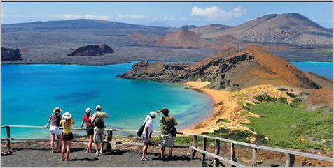
Bartolomé Island is a volcanic islet in the Galápagos Islands group, just off the east coast of Santiago Island. It is one of the “younger” islands in the Galápagos archipelago. This island, and Sulivan Bay on Santiago island, are named after naturalist and lifelong friend of Charles Darwin, Sir Bartholomew James Sulivan, who was a lieutenant aboard HMS Beagle.
Small Orange Lighthouse at the Summit of Bartolomé Island
With a total land area of just 1.2 square kilometers (0.5 square miles), this island offers some of the most beautiful landscapes in the archipelago. The island consists of an extinct volcano and a variety of red, orange, green, and glistening black volcanic formations.
Bartolomé has a volcanic cone that is easy to climb and provides great views of the other islands. Bartolomé is famous for its Pinnacle Rock, which is a distinctive characteristic of this island.
It has two visitor sites. At the first one, one may swim and snorkel around Pinnacle Rock; the underwater world there is really impressive. Snorkelers are in the water with the penguins, marine turtles, white-tipped reef sharks, and other tropical fish. The bay is also an excellent place to go swimming. The twin bays are separated by a narrow isthmus.
Galápagos penguins are frequently seen, and a small cave behind Pinnacle Rock houses a breeding colony. Seasonally, Bartolomé is the mating and nesting site for the green turtles. With herons, they make use of the gentler beaches. The Galápagos lava cacti colonize the new lava fields.
.
 An image from Bartolome Island
.
.
Click the link below for images:
.
__________________________________________
April 6, 2022
Mohenjo
Business, Enthralling, Human Interest, Photographs
amazon, business, Business News, current-events, Future, Hotels, human-rights, medicine, mental-health, research, Science, Science News, technology, Technology News, travel, vacation
Click the link below the picture
.
Singapore, officially the Republic of Singapore, is a sovereign island city-state in maritime Southeast Asia. It lies about one degree of latitude (137 kilometers or 85 miles) north of the equator, off the southern tip of the Malay Peninsula, bordering the Strait of Malacca to the west, the Riau Islands (Indonesia) to the south, and the South China Sea to the east. The country’s territory is composed of one main island, 63 satellite islands, and islets, and one outlying islet, the combined area of which has increased by 25% since the country’s independence as a result of extensive land reclamation projects. It has the third greatest population density in the world. With a multicultural population and recognizing the need to respect cultural identities, Singapore has four official languages; English, Malay, Mandarin, and Tamil. English is the lingua franca. Multiracialism is enshrined in the constitution and continues to shape national policies in education, housing, and politics.
Modern Singapore was founded in 1819 by Sir Stamford Raffles as a trading post of the British Empire. In 1867, the colonies in Southeast Asia were reorganized and Singapore came under the direct control of Britain as part of the Straits Settlements. During the Second World War, Singapore was occupied by Japan in 1942 and returned to British control as a separate crown colony following Japan’s surrender in 1945. Singapore gained self-governance in 1959 and in 1963 became part of the new federation of Malaysia, alongside Malaya, North Borneo, and Sarawak. Ideological differences led to Singapore being expelled from the federation two years later and it became an independent country.
After early years of turbulence and despite lacking natural resources and a hinterland, the nation rapidly developed to become one of the Four Asian Tigers based on external trade, becoming a highly developed country; it is ranked ninth on the UN Human Development Index and has the second-highest GDP per capita (PPP) in the world. Singapore is the only country in Asia with a AAA sovereign rating from all major rating agencies. It is a major financial and shipping hub, has consistently ranked the most expensive city to live in since 2013, and has been identified as a tax haven. Singapore is placed highly in key social indicators: education, healthcare, quality of life, personal safety, and housing, with a home-ownership rate of 91 percent. Singaporeans enjoy one of the longest life expectancies, fastest Internet connection speeds, lowest infant mortality rates, and lowest levels of corruption in the world.
Singapore is a unitary parliamentary republic with a Westminster system of unicameral parliamentary government. While elections are considered generally free, the government exercises significant control over politics and society, and the People’s Action Party has ruled continuously since independence. One of the five founding members of ASEAN, Singapore is also the headquarters of the Asia-Pacific Economic Cooperation (APEC) Secretariat, the Pacific Economic Cooperation Council (PECC) Secretariat, and many international conferences and events. Singapore is also a member of the United Nations, World Trade Organization, East Asia Summit, Non-Aligned Movement, and the Commonwealth of Nations. Wikipedia
.
 An image from Singapore
.
.
Click the link below for images:
.
__________________________________________
April 5, 2022
Mohenjo
Business, Enthralling, Human Interest, Photographs
amazon, business, Business News, current-events, Future, Hotels, human-rights, medicine, mental-health, research, Science, Science News, technology, Technology News, travel, vacation
Click the link below the picture
.
Vermilion Cliffs National Monument is located in northern Coconino County, Arizona, United States, immediately south of the Utah state line. This national monument, 293,689 acres (118,852 ha) in area, protects the Paria Plateau, Vermilion Cliffs, Coyote Buttes, and Paria Canyon. Elevations in the monument range from 3,100 feet to 6,500 feet above sea level (944 to 1,981 meters).
Established on November 9, 2000, by a presidential proclamation by President Bill Clinton, Vermilion Cliffs National Monument was carved from existing lands already under the management of the U.S. Government in extreme northern Coconino County, Arizona, immediately south of the border with the state of Utah. The monument is administered by the U.S. Bureau of Land Management, an agency within the U.S. Department of the Interior. The Vermilion Cliffs themselves run along the southern and eastern edges of the monument. Much of the monument’s land consists of the Paria Plateau, a flat area extending northward from the tops of the cliffs.
The Vermilion Cliffs are steep eroded escarpments consisting primarily of sandstone, siltstone, limestone, and shale which rise as much as 3,000 feet (910 m) above their bases. These sedimentary rocks have been deeply eroded for millions of years, exposing hundreds of layers of richly colored rock strata. Mesas, buttes, and large tablelands are interspersed with steep canyons, where some small streams provide enough moisture to support a sampling of wildlife.
More than twenty species of raptors, including bald eagles and golden eagles, peregrine falcons, and several hawk species, have been observed. The endangered California condor has been re-introduced into this region recently due to its remote location and lack of human habitation. Desert bighorn sheep, pronghorns, and mountain lions make up most of the large mammals found here, with about 30 more species of smaller mammals. Several examples of rare fish species, such as the flannel moth sucker and the speckled dace live in the streams of the monument. The Welsh’s milkweed Asclepias welshii, a threatened plant species that grows on sand dunes and helps stabilize them, is known to exist only in the monument and one other area in neighboring Utah. Wikipedia
.
 An image from White Pocket Vermilion Cliffs National Monument
.
.
Click the link below for images:
.
__________________________________________
Older Entries
Newer Entries
