
Click the link below the picture
.
Nearly 900 tornadoes have torn through more than 30 states so far this year, killing dozens of people, shredding buildings and landscapes across big chunks of the Eastern U.S., and costing billions. The oddly fickle and precise mix of atmospheric ingredients needed to generate tornadoes just happens to have occurred over and over again since mid-March, and the season isn’t over yet.
How do tornadoes form?
“In order to get a tornado, you need to have a thunderstorm that’s capable of producing a tornado,” says Jana Houser, a tornado researcher at the Ohio State University. Most often, these are what meteorologists call “supercell” thunderstorms, which feature a circulation pattern called a mesocyclone.
Supercell formation requires a set of conditions that make the atmosphere unstable, and these start with warm, moist air at the surface and cold, dry air above. The instability comes from warmer air’s greater buoyancy, which makes it rise upward. And this mix needs yet another specific ingredient, wind shear, “where winds change speed and direction as you go up with height” in the atmosphere, Houser says. This can create sort of a “tube” of horizontally rotating air. Next, the nascent twister needs an updraft, or upward-moving air, which tightens and speeds up the rotating air, taking it “from spinning like a bike tire” to “spinning like a top.”
All of these conditions are necessary, but they’re still not always enough. “Most supercells don’t even actually produce tornadoes in their lifetime,” Houser says.
The exact mechanics of tornado formation aren’t yet fully understood, but essentially, air rotation at the ground needs to meet a strong updraft aloft; this pulls the rotation in like a figure skater pulling in their arms, as Houser puts it.
Where do tornadoes form?
Tornadoes can—and do—happen wherever the right conditions are present, from Argentina to Italy to Bangladesh. But the U.S. is by far the leader in the average annual number of these storms. North America’s geography naturally promotes a crucial collision of air masses: juicy air streams northward from the bathtub warmth of the Gulf of Mexico, while cool, dry winds rush eastward over the Rockies. The air masses meet over the center of the country, which is how the region centered around northeastern Texas and Oklahoma came to be called Tornado Alley. “If you were to design a place that would get repeated severe storms, you would build something like the central U.S.,” says Rich Thompson, chief of forecast operations for the National Weather Service’s Storm Prediction Center.
But over the past decade or so, that tornado bull’s-eye has changed a bit. A “new Tornado Alley” has emerged about 400 or 500 miles to the east, in part because moist Gulf air is reaching farther east than in the past.
Why do tornadoes mainly form in spring?
“Spring tends to be the peak because it’s a transitional season,” Houser says. Coming out of winter, there is still abundant cold air at northern latitudes and aloft, and at the same time, the sun is shining much more, heating up the surface air to promote instability.
Fall is also a transitional season, but the air aloft remains generally warmer for some time after summer. Tornado activity doesn’t tend to pick up again until later in the fall, when the atmosphere has cooled down again.
The local peaks in tornado occurrence tend to move northward as spring rolls into the summer: the Gulf Coast peaks earlier in the spring, the Southern Plains in May and June, and the Northern Plains and upper Midwest in June and July.
.
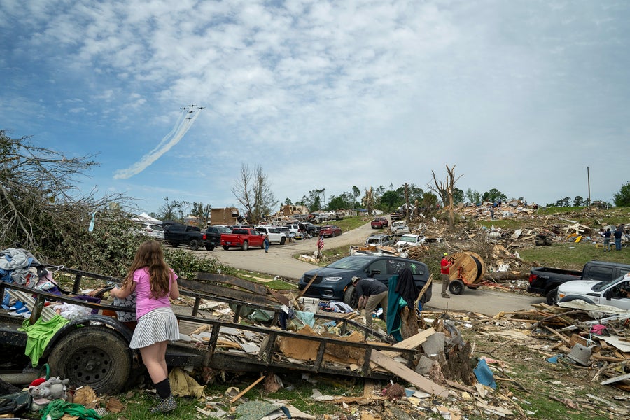
A U.S. Air Force aerobatic team flies in formation over community members and crews cleaning up debris on May 18, 2025, in the community of Sunshine Hills outside of London, Ky. A tornado struck the neighborhood just after midnight on May 17, 2025. Michael Swensen/Stringer/Getty Images
.
.
Click the link below for the complete article:
.
__________________________________________

Leave a comment