
Click the link below the picture
.
Another explosive wildfire in California, driven by the region’s notorious Santa Ana winds, has burned thousands of buildings and has forced thousands of people to evacuate from their homes. The Palisades Fire began at 10:30 A.M. local time on Tuesday near Los Angeles’s Pacific Palisades neighborhood. Much of the neighborhood is under evacuation orders, which extended to northern Santa Monica. As of Thursday morning, the fire had scorched more than 17,000 acres and destroyed more than 2,000 structures.
Another blaze, the Eaton Fire, erupted on Tuesday evening in Altadena, Calif., just north of Los Angeles. As of late Wednesday, it had burned more than 10,000 acres and resulted in at least five deaths. Both fires had caused numerous injuries, according to officials.
On Wednesday evening, another fire began in the heart of Los Angeles just north of Hollywood. The fire grew rapidly to cover more than 40 acres as it spread downhill in Runyon Canyon. Though winds were not as high as Tuesday night, they were still pushing the fire and carrying embers that started spot fires. Helicopters made water drops, which helped beat back the flames.
Forecasters had warned that the risk of fire was extremely high this week, reaching “particularly dangerous situation” status as the ferocious winds combined with tinder-dry vegetation after a lack of rain during the beginning of what would usually be the wet season.
Gusts around the Palisades Fire were measured in the range of 40 to 50 miles per hour as of Tuesday afternoon, climate scientist Daniel Swain said during one of his regular “virtual climate and weather office hours,” hosted on YouTube. “Right now the winds are not extremely high, but again, they’re high enough,” said Swain, who is at the University of California Agriculture and Natural Resources. Gusts were expected to reach 70 to 80 mph as the winds would peak on Tuesday night into Wednesday, with some places potentially seeing gusts as high as 100 mph. Gusts of 99 mph was measured in the San Gabriel Mountains north of Pasadena, Calif.
What Are the Santa Ana Winds?
The Santa Ana winds commonly propel fast-moving, damaging fires in this area; their characteristic dryness and speed can rapidly fan and spread flames. These winds are a result of local geography and a particular meteorological setup in which a high-pressure system sits over the Great Basin in the interior of the U.S. West and a low-pressure system hangs over California or offshore. Winds “want” to move from high to low pressure, and as they do so in this area, they travel downslope from the relatively high deserts. This descent compresses the air, warming it up and drying it out. (Such downslope winds, which happen in other locations around the world, are scientifically termed katabatic winds.)
The Santa Ana winds are additionally funneled through narrow mountain canyons, which causes them to speed up. The hot, dry, and fast nature of these winds makes them perfectly suited to spreading flames from any spark that ignites. The winds blow embers well ahead of the fire front, starting new spot fires. “Those embers are going to follow the wind and burn whatever they want,” Swain said in another video on YouTube on Tuesday.
In a couple of respects, this Santa Ana wind event isn’t a typical one: it “is especially extreme and is reaching lower elevations than usual with strong winds,” Swain said in another briefing on Wednesday morning.
Is Climate Change Playing a Role in the Los Angeles Fires?
The timing of the event is more in line with the norm: Santa Ana events typically happen from October through January. Part of what is raising fire risks from these events, though, is related to the influence of climate change on fluctuations in the region’s precipitation.
.
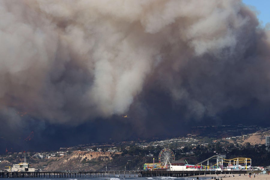
The Palisades Fire on January 7, 2025. ZUMA Press, Inc./Alamy Stock Photo
.
.
Click the link below for the complete article:
.
__________________________________________

Leave a comment