
Click the link below the picture
.
When tropical meteorologists peer at satellite images, they often catch sight of subtle cloud formations hinting at something more ominous brewing.
The first signs of a potential hurricane can be detected days before a storm gains its fierce momentum. Wispy cirrus clouds radiating outward, the appearance of curved banding low-level clouds, and a drop in atmospheric pressure are all clues.
These early clues are crucial for predicting the onset of what might develop into a catastrophic hurricane.
I am a meteorology professor at Penn State, and my research group uses satellites and computer models to improve forecasting of tropical weather systems. With an especially fierce Atlantic storm season forecast for 2024, being able to detect these initial signals and provide early warnings is more important than ever. Here’s what forecasters look for.
Conditions ripe for a hurricane
Hurricanes typically start as atmospheric tropical waves, areas of low pressure associated with clusters of thunderstorms. As these tropical waves move westward across tropical oceans, some of them can develop into hurricanes.
The formation of a hurricane hinges on several specific conditions:
Distance from the Equator: Tropical cyclones usually form at least 5 degrees from the equator. This is because the Coriolis force, crucial for the initial spin-up of the cyclonic system, is weaker near the equator. The Coriolis force is caused by the Earth’s rotation, which makes moving air turn and swirl.
Warm sea surface temperatures: The sea surface temperature must be at least 26.5 degrees Celsius (about 80 Fahrenheit)for a hurricane to form. The warm water provides energy that drives the storm as the storm absorbs heat and moisture from the ocean.
Atmospheric instability and moisture: For tropical cyclones to form, the atmosphere needs to be unstable. This means that warm surface air rises and remains warmer than the surrounding air, allowing it to keep rising and forming thunderstorms. There also needs to be plenty of moisture, as dry air can cause clouds to evaporate and weaken the upward motions within thunderstorms. These factors are essential for the development of clustered thunderstorms within the tropical waves.
Low vertical wind shear: Strong vertical wind shear can tear a developing hurricane apart. Vertical wind shear is changes in wind direction or speed at different elevations. It disrupts a storm’s formation and growth and makes it hard for a hurricane to keep its vortex aligned.
Early forecasting requires more than satellites
Recognizing the early stages in the life cycle of a hurricane has been very challenging because there aren’t large numbers of surface stations and weather balloons to provide detailed atmospheric information over the open ocean.
.
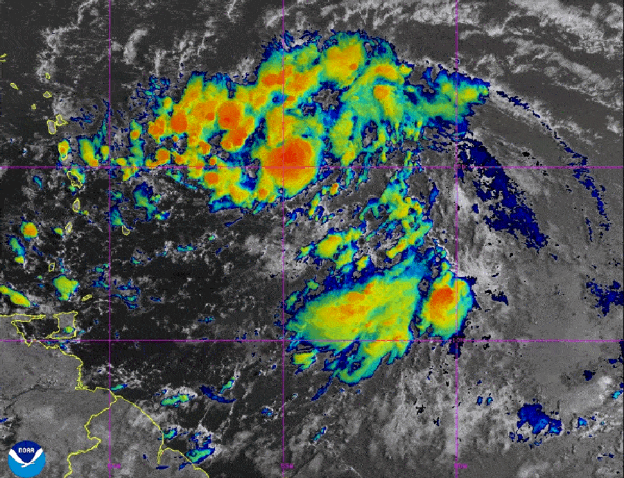
On August 12, 2024, forecasters were watching for signs that Potential Tropical Cyclone Five would develop into a hurricane. Later that day, it became Tropical Storm Ernesto and was forecast to become a hurricane later in the week. NOAA/NESDIS/STAR – GOES-East
.
.
Click the link below for the article:
.
__________________________________________

Leave a comment